

As you may have sussed from the header graphic, this was my eighth Loop 202 South Mountain Freeway survey hike. My first one was April, 2015, when the freeway was approved. My previous survey was April, this year.
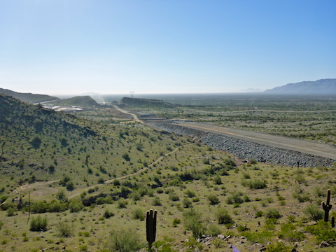
A year ago, work had advanced to 59th Ave. & Estrella Dr. Six months ago to 51st Ave. & Dusty Lane. Now, all the way from Dusty Lane to Pecos Rd.
There is a community along Dusty Lane, behind the Vee Quiva Casino, just off the Gila River Indian Community. As I’ve documented in previous blogs & videos, at least half of the properties were condemned for freeway use. So, when I arrived in Dusty Lane just before dawn, today, many of the roads were blocked by construction signs. I could not legally park at my normal spot on 43rd Ave. between Choppo Rd. and Galveston St. 😕
I wandered around Dusty Lane a bit before I found a legal space to park at the east end of Ivanhoe St. The only signs were warning reflectors to prevent someone motoring off across South Mountain Park. I settled in to eat my QT breakfast and drink coffee, while waiting for enough daylight to take pictures.
A guy came out of his house and approached my car. I rolled down my window.
Local: “Anything I can help you with?” (No “hello”? Okay …)
Me: “Just parking here.” 🙂
Local: “How come?”
Me: “I’m going to go for a walk in the park.”
Local: “You’re not allowed to park here.”
Me: “There’s no ‘No Parking’ signs.”
Local: “Do you need one?”
Me: “Uh, why do you ask?”
Local: “None of us like people parking around our houses.”
Me: “Okay. Alright. No problem.”
Like I said, I was legally parked there. But I heard banjoes. Because he could have fucked with my car while I was gone, with no way for me to prove it, I decided it was better to leave him to enjoy his misery and move on.
Because San Juan Rd. is only open one weekend a month, I drove over to the Alta Trail trailhead on 43rd Ave. & Estrella Dr. So, I know where I will be on Saturday, April 7, 2019. Parking at Bajada Trailhead will save me hiking 3.5 miles, giving me more time for exploring.
I hiked south up to the San Juan Trailhead, which has a nice cabana, but no pit toilet or even portapotty. (There was one or the other every few miles on the C&O Canal Towpath, last week.)
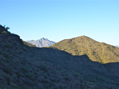
I followed an obvious, but unnumbered, trail southwest up Alta Ridge. The trail petered out in .75 miles, so I started side-sloping along the north face of the ridge. It was slippery, slow, going. It took me 20 minutes to go a ¼ mile, where I reached a saddle, and was able to make my way up to a hilltop overlooking Dusty Lane. 😅
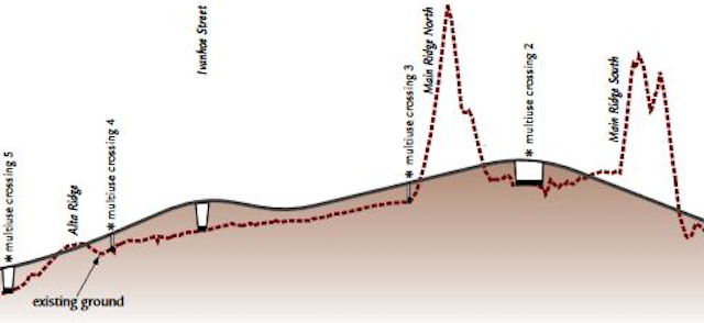
Six months ago, a dirt construction access road had been built over Main Ridge South and Main Ridge North to the intersection of Choppo Rd. & Dusty Ln. Also, land had been prepared from 59th Ave. & Estrella Dr. down to 51st Ave. & Dusty Ln. Since April, extensive prep work & base buildup has been done all the way from 51st Ave., across Dusty Lane, all the way to Pecos Rd. (I assume: This trip I did not cross Main Ridge South.) Which is why I had trouble finding a parking spot.
Despite attending Milwaukee School of Engineering, I am not a highway engineer. So, if I get some terms wrong, I apologize. Building web sites is more my speed. 😁
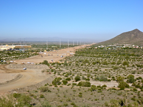
I descended straight off Alta Ridge towards the north end of 43rd Ave., then I worked my way south, along the Loop 202 South Mountain Freeway construction zone. There were a lot of wood boxed Palo Verde, for beautification, staged at 43rd Ave. & Choppo Rd. The culverts between Choppo Rd. and Main Ridge South were in various phases of installation: I saw one crew positioning two metal pipes at one culvert, and another crew pouring concrete over three metal pipes at another culvert. Culvert #5, a concrete box culvert, was complete.
Culverts are meant to allow water to harmlessly flow under the Loop 202 South Mountain Freeway. The Center Segment also has at least four multiuse crossings, which I understood to allow hikers, mountain bikers and even horse riders to safely pass under the roadbed. Like the big tunnel on Charles M. Christiansen Trail #101 that passes under the Piestewa Freeway. But multi-use crossing #3, at the bottom of Main Ridge North’s north slope was simply road bed. Why put down road bed, only to later cut it out to install the multi-use crossing? 🤔
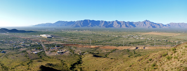
There’s a jeep trail that runs from waypoint #16 / multi-use crossing #3 0.75 northeast to where Goat Trail crosses a saddle between Dusty Lane and the Graffiti Ranch. My plan had been to head that way, then work my way back along the top of Main Ridge North, to a point overlooking waypoint #15 and the power tower atop the ridge. But instead, I decided to hey diddle diddle and went straight up. I could see all the way from 51st Ave. to Main Ridge South. 🔭
Main Ridge North has had more work done on it, but it has not been cut. Main Ridge South, on the other hand, has a deep cut in it. If you look at the profile, up top of this page, you will see where all the cutting and lifting / filling occurs.
From there, I dropped down to an old ranch I don’t believe I have explored before. I dubbed it Plumbing Ranch, because it has an old ceramic sink laying about, a circular concrete pad edge by stone, and a concrete foundation with PVC pipe running out into the wash that eventually leads to culvert #4.
Some of the washes at the west end of South Mountain Park can be quite steep, if not deep, and it often takes a few minutes to find an easy way across. Plus, washes are good places to find artifacts that have washed down from old mines & ranches. 😉
From Plumbing Ranch, I followed old jeep trails around the valley between Main Ridge North and Main Rdge South. As I expected, the R.A. Steele Ranch (c. 1940) ruins have been plowed under. I was pleasantly surprised the Rock Wall Ranch appears to have survived the construction of the road bed. (If not the fire which burned it down years ago.)
I was surprised that not as many houses had been completed at Taylor Morrison’s new luxury development, “The Promontory at Foothills West Summit Collection Community”. Try saying that five times real fast. Or even twice. 💸
I could not spot multi-use crossing #2, near the luxury development. I did not feel like low crawling a culvert, nor did I want to interfere with construction by crossing the road bed, so I decided to head back to my car, rather than continue to waypoint #6 or #7 at the top of Main Ridge South.
I was shooting my hike video’s outro at the Graffiti Ranch when I heard a voice. It was a gentleman I had earlier seen below me, hiking past the R.A. Steele Ranch. His name was Allan, and we had a good long talk about photography and how Phoenix has changed over the decades. (He first moved to Phoenix in the 1960s.)
From the Graffiti Ranch, I headed back up to the Goat Trail saddle, then cut across country to San Juan Rd. I was pretty tired, and had twisted my ACL-less knee, so rather than continue cross country, I trudged up the blacktop to the San Juan Trailhead, then back down to my car at 43rd Ave. & Estrella Ave.
GPS File: Loop_202_South_Mountain_Freeway_20181107
Distance: 7.83 mi.
AEG: 1,314 ft.
Time: 3h 22m
Hike Video
Loop 202 Survey Hike #8 (11/7/18) from Preston McMurry on Vimeo.