

Bajada → Ranger → National → Goat Hill → National → Bursera → Gila → National → Bajada
I had planned to hike to Peter’s Cave, out near Tortilla Flat, in the Superstition Mountains, but with recent heavy rains, I figured it might be safer to avoid a narrow canyon hike. Plus, it would involve a fair amount of bouldering, and my right arm is somehow messed up. (As I type this, I just got back from having it x-rayed.) I wanted to get some miles, and elevation, but not drive too far, or anywhere too cold, so with morning temps down into the 30s, I looked around the Valley, settling on South Mountain Park.
I’ve been out to the far west end of the South Mountain Park every six months for the past two years, doing my Loop 202 South Mountain Freeway survey hikes, so I figured I would combine a more exercise-oriented hike with a quick progress check of the luxury housing development going in right next to the new freeway’s path. (That’s not a typo.)
My plan was to hike from the Bajada Trailhead, east on Bajada Trail to Ranger Trail, make the only ascent of the day 700 ft. to National Trail, “summit” Goat Hill, continue west on National Trail, checking out any mines, before turning south on Bursera Trail, then east on Gila Trail to the new housing development, continue north on Gila Trail to Main Ridge North, reconnect to National Trail, then take Bajada Trail back to the trailhead.
Every time I have been into the middle of South Mountain Park, San Juan Rd. has been closed. Every time. As it was again. Thankfully, it is not illegal to park in the “triangle” at the intersection of Central Ave., Summit Rd. and San Juan Rd.
The last time I did the South Mountain Loop was six years ago. I only gave the various mines a quick glance, and did not take a single picture. So, no hike video. I didn’t start creating hiking videos until late 2013, when I explored the Climax Mine. I’m still no Thelma Schoonmaker, but I think you’ll agree today’s effort is a much better editing job than that first one. ![]()
It was 25° cooler Friday than it was six years ago: 42° in Phoenix, but only 35° at the trailhead. Good thing I wore my windbreaker!
When I started hiking at 7:40 a.m. it was light enough to walk without a headlamp, but still dark in the park.
Bajada Trail is slightly downhill for .75 miles to Ranger Trail. If you hear shooting on Bajada Trail or Ranger Trail, it is not hunters or South Phoenix gangs, but rather the Arizona Law Enforcement Academy, on the park’s north edge. No worries.
Ranger Trail ascends a bit before re-crossing Summit Rd., after which it climbs through a series of switchbacks up to National Trail. Not really any good places to pee, even deep in the switchbacks, as you are always in sight of Summit Rd. Indeed, no real private spots anywhere on this loop, other than in the washes of Gila Trail. Keep an eye out near the top for the newerish connection to National Trail, which is 50 yds. before the saddle. If you miss it, no big, just take the next right onto National Trail.
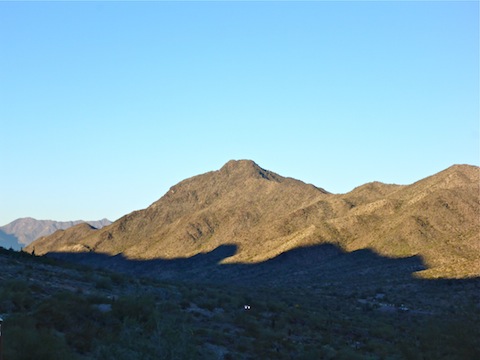
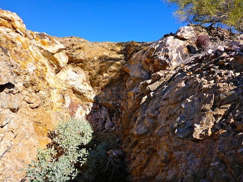
National Trail follows the “military crest” of the South Mountain ridge, that is it does not go right over the tops of the ridge’s hills, but rather winds to the south or north of each rise, alternating views of the park’s inner basin with views of the new freeway’s progress along Pecos Rd. (So far, none is obvious that far west.) It’s basically flat for a mile to the intersection of Lost Mine Ranch Trail, before beginning a slow descent to Bursera Trail. Where Ranger Trail gets your blood pumping, National is a pleasant stroll. There’s at least six prospects / collapsed mines along National Trail, only one of which is penetrable, and then only for about 20 ft. Take care near the mines, as none have safety covers or fences. National’s cholla and hedgehog cacti glow in the morning sun.
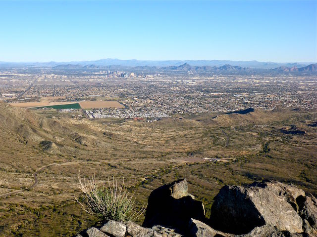
Goat Hill is a short spur off National, just past the first trailside mine. Keep an eye for a marker indicating where to split north, as it is not obvious. I intially walked right past it. It’s only another 100 ft. climb to the “summit”, but it is steep and quite slippery. Goat Hill has great 360° views of Sky Harbor Airport, Camelback Mountain, Piestewa Peak, North Mountain, Shaw Butte, downtown Phoenix, Maricopa Peak — I errorneously referred to it as Alta Peak on my hike video — Dusty Lane, the Gila River Indian Community, Pecos Road as far as Firebird Lake and Mount Suppoa (aka, “South Mountain” itself).
Bursera Trail makes a short climb from National Trail, before descending about 250 ft. through an overkill of switchbacks. It was like hiking Lombard Street in San Francisco. Halfway down, it looked like I was following new trail, as my crappy Garmin 62S was no longer accurately tracking on my intended route, or the actual ground I was walking on. Not long before the intersection with Gila Trail, I noticed that someone had tried to drive an ATV up the trail, as there were a number of fresh tire tracks cut into the grass. Diverting onto Bursera Trail and Gila Trail only adds a .75 miles and 200 AEG to the loop. At the bottom, it was obvious there was something wrong with my crappy Garmin 62S, so I reset the compass, saved my current track, cleared, then started a new track.
Gila Trail starts out as old jeep trail as it follows the top of a deep, vertical-sided wash, west towards the luxury housing development. Several of the washes — though not the biggest — appear to have been plowed over to create lots, which is not a good thing as I saw no obvious diversion tunnels. Apparently, the only work in the past three months is they’ve begun putting up some community walls. I hope the future residents enjoy paying big bucks to be serenaded by freeway traffic.
After checking out the luxury housing development, I realized my crappy Garmin 62S was well & truly fucked. It literally had me walking in a direction 180° opposite of my actual direction, making a 900 ft. climb I did not perform, and travelling along a ridge when I was at the bottom of a canyon. Despite showing accuracy of 19 ft., the track was as much as 1500 ft. from my actual location. My crappy Garmin 62S has fucked up in many ways over the years, but that was a new one. Luckily, I was in an area I knew well, and so was able to continue on the Gila Trail. If you are out in the boondocks, don’t depend on a crappy Garmin 62S to save your life.
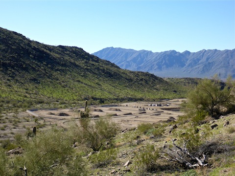
After crossing the R.A. Steele ranch ruins valley, I connected back to National Trail. Ironically, at that point, my crappy Garmin 62S again began to reflect reality. (Though later analysis of the elevation profile showed me as much as 1000 ft. above my actual elevation, flying along amongst the red-tailed hawks and turkey vultures.) The final segment of National Trail to the Bajada Trailhead is short and unremarkable.
Bajada Trail starts at the Bajada Trailhead, not that it does any good with San Juan Rd. being closed. But at least it had a porta potty. Between the Bajada Trailhead and the parking “triangle”, Bajada Trail is a trudge, particularly if you already have eight miles under your belt. It crosses uncountable washes, many fairly significant, while climbing 350 ft. in its first 1.5 miles. It was tiring. I stopped for a sit down break. Thankfully, the final mile is downhill, then level. I had planned to check out the Max Delta Mine — you can see the old mill site on sat view, just below Goat Hill — when I got near the parking “triangle”, but by that time I believed I had done “13.0 miles” and “2900 AEG”, so I decided I had done enough work for the day and skipped it. (Of course, my crappy Garmin 62S porked those numbers right in the pooper.)
Park Map: South_Mountain_Park_Trail_Map (pdf)
GPS File: Bajada_Ranger_National_Bursera_Gila_Loop
Distance: 10.83 mi.
AEG: 1,488 ft.
Time: 4h 26m
South Mountain Hiking Video
Hiking South Mountain, Phoenix from Preston McMurry on Vimeo.