

After my last hike, on Prospect Trail in Nevada’s Valley of Fire, it was back home this week.
Being winter, I planned another ‘Locals Hike’, the term I give to hikes that are not too long, not too rugged and are within the Valley of the Sun. In other words, something our winter visitor’s — i.e. “snowbirds” — should be able to handle. (Depending on far past Social Security you are.) 👴🏻👵🏻
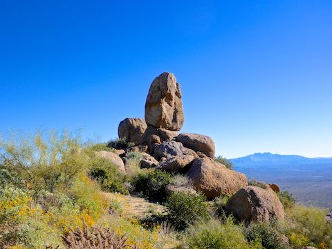
I can’t really talk, I’m 56, and my age would play a role in today’s planned hike from Tom’s Thumb Trailhead, up Mesquite Canyon on the Climbers’ Access Route to the top of East End Mountain, then over to Ogre’s Den & Tom’s Thumb, then back to the trailhead on Lost Wall Trail.
I did not wake up until 5:30 a.m., the time I usually hit the road. Rather than fight rush hour only to sit at the trailhead for 90 minutes waiting for enough light to take photos, I took my time getting ready. I was on AZ-51, the Piestewa Freeway, a few minutes after 9:00 a.m., making it legal for me to use the rush hour-only diamond lane. 🏎
I made good time to north Scottsdale, but it was a longer drive to McDowell Sonoran Preserve than I expected. Tom’s Thumb Trailhead is massive, bigger than the North Mountain Visitor Center or anything around Piestewa Peak. There was a steady flow of hikers & rock climbers headed up Tom’s Thumb Trail, but the parking lot still had plenty of empty spaces.
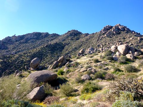
I headed through the shady rest building, onto Tom’s Thumb Trail, for a brief tenth of a mile, before hanging a left onto Mesquite Canyon Trail.
In a ¼ mile, Mesquite Trail intersects Feldspar Trail. I couldn’t have been on Feldspar more than a few yards before turning southeast up what I believe is Mesquite Canyon. (Mesquite Trail actually continues east, into McDowell Mountain Regional Park, not up canyon.)
The Climbers Access Route starts as you head southeast. Note that it is not on the official McDowell Sonoran Preserve trail map. The trail crisscrosses a sandy wash. Every couple of hundred yards there is a an ancient Climbers Access Route sign, with directions to various rock climbs. I remember seeing CR-23 and CR-27. (The numbers represent emergency coordinates for use in an emergency.) No idea how high the numbers go, or where CR-1 might be. 🤔
Three quarters of a mile into the hike, the Climbers Access Route angles sharply upwards for a ¼ mile. There’s several good step ups, and much slippery pea gravel over rock. At the top is a small, grassy, meadow.
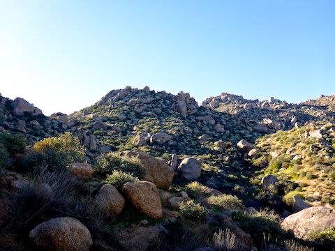
From the saddle, the trail is no longer signed, but is still obvious, and occasionally cairned. (Note that a cairn may only be one or two rocks.) Winding between large outcroppings, the trail climbs 100 ft. in a quarter mile, to an observation point with 180° views from Bartlett Lake past Fort McDowell & Fountain Hills, to the Goldfield Mountains, Weavers Needle and Flatiron to the south.
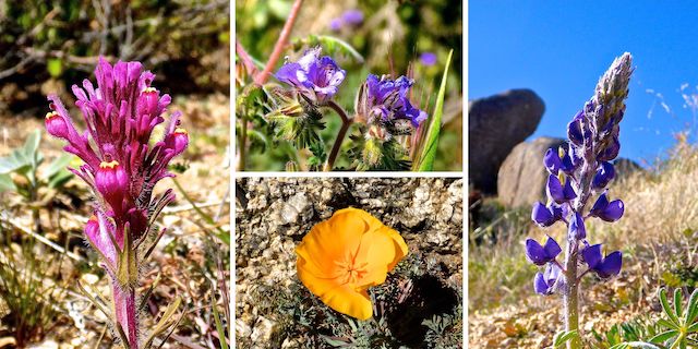
There were quite a few flowers between the saddle and the OP, particularly brittlebush, which have been blooming non-stop since November. 🤗
There was still ice on shadowed parts of the trail at 3260 ft. I had to be careful with my footing, particularly in the next ¼ mile, as the trail was often off camber, and crossed multiple narrow 3 ft. deep gullies. No threat of death, but a sprained ankle would still suck.
A mile and a half into the hike, the trail peters out. It’s still cairned, but no longer so obvious. Just before the route begins its final 700 ft. climb to the summit of East End Mountain, at a cluster of large boulders, I hit a dead end. 🚫
Not literally a dead end, but the route crossed the boulders, which were each separated by a fairly decent gap. A younger person — I am 56, with no ACL in either knee — might have leapt across, but the top of each landing boulder was slanted, and the gaps deep enough that slipping in would have been limb breaking.
I spent a few minutes looking for an alternate route, but eventually decided to bail. I’ll be back, but next time, I will stick to the official route up to Ogre’s Den and Tom’s Thumb. 😉
Directions: From Loop 101 / Pima Freeway, take exit 36 north onto Pima Rd. In 4.8 miles, turn right onto Happy Valley Rd. In 4.3 miles, turn right onto Ranch Gate Rd. In 1.3 miles, turn right onto 128th St. The Tom’s Thumb Trailhead is in 1.4 miles, just past the traffic circle. There is no entry fee.
GPS File: Climbers_Route_to_Toms_Thumb
Distance: 3.31 mi.
AEG: 861 ft.
Time: 1h 43m
Hiking Video
Hiking Tom’s Thumb Climbers’ Route from Preston McMurry on Vimeo.
Nice hike and I liked the soothing music.
Thanx! Sounded like Spanish guitar, to me. 🙂