

Last night, after planning this hike — downloading the route, etc. — I got a tweet from the Tonto National Forest that most of the recreation sites at Bartlett Lake had reopened. I checked out the link, and apparently there was quite a bit of flooding on the access roads on Monday and Tuesday. (When we were getting sheets of rain in Sunnyslope, they got something like two inches in Cave Creek, which isn’t far from Bartlett Lake.)
Directions: To get from Loop 101 & Pima Rd. to the trailhead at Rattlesnake Cove, head north on Pima Rd. for 12 miles. Go east on Cave Creek Rd. for a little over four miles. Then head east on Bartlett Dam Rd. for a little over 13 miles. Just before the marina, turn north on FR 459 for just under a mile, turning east onto Lower Rattlesnake Rd. to Rattlesnake Cove. You need a Tonto Day Pass, currently $8. Passes are available at the marina (which opens at 9 a.m.), the ranger station at the corner of Cave Creek Rd. & Bartlett Dam Rd., or from lots of gas stations in the Valley.
I forgot a lot of stuff this morning, include my pocket ziplock baggie, where I keep my phone and a pair of AA batteries. I had also failed to put my electronics ziplock, including a second set of AAs, into my pack. That became an issue when I arrived at Rattlesnake Cove, on the shore of Bartlett Lake, and turned on my crappy Garmin 62S. While I waited five minutes for it to find a satellite, I realized I was down to two bars of battery power. Oops.
As a result of my power shortage, I hauled as much ass as I possibly could without inducing a coronary.
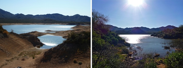
Palo Verde Trail #512 follows the west shore of Bartlett Lake from Rattlesnake Cove to SB Cove, the next recreation area a few miles north. Both have a ton of parking and multiple picnic / grill sites. Rattlesnake Cove has a fishing dock and flush toilets. SB Cove has multiple pit toilets, and you can drive your camper onto the beach. Both were nearly empty midday Thursday.
The trail hews very close to the west shore of Bartlett Lake, winding back & forth, dipping into, and climbing out of, many washes. The last time I hiked Palo Verde Trail #512, five years ago, the water was down around 20 ft., so the shore was as much as 100 yds. further out. I remember seeing a bouy on dry land.
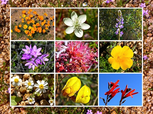
There’s a lot of flowers on this hike. I’m not a plantologist, but there were tons of Mexican Gold Poppy, as well as fairy dusters, lupine, and other species I don’t know the names of. One purple species, in particular, gave me real trouble trying to get a half decent focused shot. As last week at Alamo Lake, the Mexican Gold Poppy opened up around 10:30 a.m.. They were going nuts on the far side of Bartlett Lake, so much so that dense patches were visible from two miles away!
There’s a few cairns, but despite my then inexperienced self managing to wander off trail my first time out here, they really aren’t necessary. What is more common than cairns are what, for want of a better term, I’ll call “guide stones”: lines of 10 or 12 fist-sized stones that say “don’t wander off this way”, keeping you on track. Hopefully that makes sense?
Thankfully, there is very little signage, other than at Rattlesnake Cove, and at either end of the shortcut. (Which saves you about a mile hiking out to a peninsula south of SB Cove and opposite Alder Point.)
There is also very little garbage, until you get near the camping areas at SB Cove. Just after I started my hike, I noticed a Coke can, which I speared with my hiking pole on my return trip. I was surprised it was not a Bud Light, like most of the hiking garbage I find.
It was chilly when I started hiking: Enough so that I was wishing I had brought my windbreaker, or that hoodie I bought in Bouse a few months ago. Bartlett Lake is in a basin, around 1800 ft., which is well below Carefree at 3200 ft. That seems to make the basin both cooler in the morning, and warmer in the afternoon. It was 54° when I started hiking at 8:30 a.m.; when I finished at 12:30 p.m., the temperature was up to 83° — nearly 30 degrees higher! A half hour later, back up the hill in Carefree, it was low 70s.
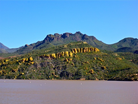
After I arrived at SB Cove, I took a break in a picnic cabana, downing some fluids & eating some chips. (Some gluten-free vegan thing with chia seeds: Enh.) Then I sat on the embankment for about 15 minutes, mellowing out, admiring the Yellow Cliffs and watching the waves ripple in the sunlight.
Then I hauled ass back to Rattlesnake Cove, trying to beat my dying GPS batteries. Almost made it, falling only a quarter mile short.
GPS File: Palo_Verde_Trail_512
Distance: 8.25 mi.
AEG: 1,071 ft.
Time: 3h 13m
Palo Verde Trail Video
Hiking Palo Verde Trail #512, Bartlett Lake from Preston McMurry on Vimeo.
Yes, it is so gorgeous and sparsely populated out there. My mom hiked this trail last week upon reading your review. The wildflowers were in full bloom and the sparkling lake beside us all along the hike made it magical. One of my new favorites, thank you!
Nice captures and commentary!.
Thank you for sharing,
Kelly
Thanx Kelly! I really like the way the sun glinted off Bartlett Lake.