Unlike most of metro Phoenix, which is laid out in one mile squares, the roads in Queen Creek are all curley. So, for the third time in three trips to San Tan Mountain Regional Park, I made a couple of wrong turns on the 60 mile drive from the North Mountain area of central Phoenix. (The Valley of the Sun is enormous.) 🌅
When I last hiked San Tan Mountain Regional Park a little over two years ago, I hiked the central part of the park. Today, I hiked a lasso at the south end of the park on all Rock Peak Wash Trail, part of San Tan Trail, all of Hedgehog Trail, another bit of San Tan Trail, all of Malpais Trail, a third bit of San Tan Trail, and finally back to where I started on Rock Peak Wash Trail.
Malpais Trail and Hedgehog Trail would be new ground for me, the former thankfully more isolated than the latter.
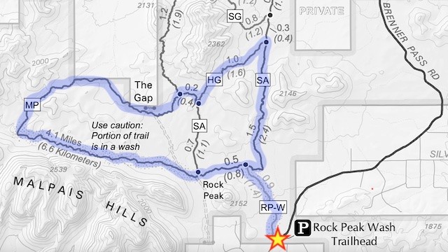
One of my very earliest Arizona hikes was from Rock Peak Wash Trailhead in 2010. I didn’t see any vehicles there today, and don’t recall any back then either. Most people figure, if you have to pay to park, they might as well do it at San Tan Mountain Regional Park’s main entrance, where there are toilets and water. Not me.
Unfortunately, I had used my only $5 bill to tip the waitress at the Queen Creek Denny’s where I had breakfast. Then I stuck my spare singles in the VFW donation jar. When I arrived at Rock Peak Wash Trailhead, all I had left was a twenty, and I sure as hell was not going to over-pay the fee. But I would pay, because I’m a good boy. 😇
So, I put $7 of car console change into the parking envelope. But the envelope was too fat for the slot. I reopened the envelope, fed half the coins directly into the slot, dropped the still open envelope in, and was on my way by 8:35 a.m.
Rock Peak Wash Trail gains 90 ft. AEG (accumulated elevation gain) in just under a mile. That AEG wouldn’t even tax a Sun City resident. But the deep sand would. Rock Peak Wash is wide & shallow, and has several “islands” in its dry bottom. The “islands” are brushy, but also provide firmer footing.
I hiked San Tan Mountain Regional Park two months later than in 2020, and it paid off in flowers. Not a lot, by any means, but a least some, which keeps my hike videos from being an endless series of trail shots. 😉
The first flowers I saw, along Rock Peak Wash Trail, were scorpion weed, which are among Phoenix’s most common flowers, along with brittlebush and creosote. I also spotted scattered tiny Coulter’s lupine and single patches, with a few blooms each, of Mexican gold poppy, desert marigold, Mojave desert star and Moapa bladderpod. None of the saguaro, barrel cactus, hedgehog cactus or cholla were blooming.
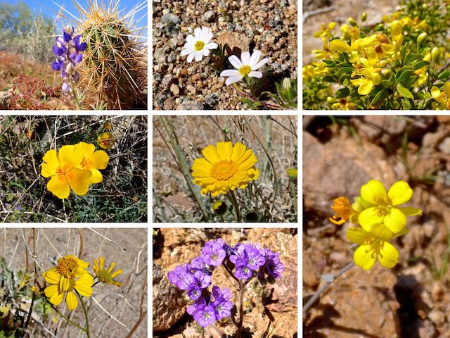
Top Row: Coulter’s lupine, Mojave desert star, creosote.
Middle Row: Mexican gold poppy, desert marigold, Moapa bladderpod.
Bottom Row: brittlebush, scorpionweed.
San Tan Trail is a proper trail, not wash bottom. It is obstacle-free and fairly wide. From Rock Peak Wash Trail, San Tan Trail climbs 200 ft. in ¾ mile to a saddle, with a rest bench. Then it descends another ¾ to the junction with Hedgehog Trail. In that 1½ miles, on a Wednesday morning, I counted 1 dog walker, 23 hikers and 8 mountain bikers. Busy!
Hedgehog Trail climbs 100 ft. in a ½ mile to a saddle. There’s a rest bench on the saddle. (One of four — 4! — the next ½ mile.) I took a break to swap water. To get a better photo, I tried baiting a Harris antelope squirrel with some gorp, but he was too cagey. Meanwhile, a horse rider rode by. He didn’t seem to be completely in control of his mare, riding it close to the bench. I was leary of getting kicked when he turned around right in front of me. 🥺
At the west end of Hedgehog Trail, there is a bike repair stop. I turned north on San Tan Trail (again) for a ¼ mile, before turning west onto Malpais Trail.
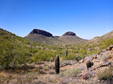
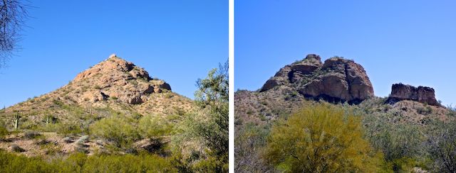
Malpais Trail is relatively flat for 1¼ miles along a wash, then a barbed wire fence, before climbing 100 ft. in ⅓ mile to the saddle you see above. No benches anywhere on Malpais Trail. It’s the most hikey hiking in San Tan Mountain Regional Park. Malpais Trail then descends 150 ft. in a ½ mile to a sandy wash at the foot of the two buttes. I passed three friendly horse riders, in much better control of their steeds, admiring the view.
Malpais Trail turns east, still in the sandy wash for another ¾ mile. I got briefly diverted into a side wash. The trail then makes a short climb to the second saddle, with nice views east, along the Malpais Hills, towards Rock Peak. It was getting pretty toasty — the temp was 85℉ an hour later at the trailhead — so the bit of shade came in handy while I ate lunch and rehydrated with my hiking beer. 🥪 🍺
Malpais Trail then descends to a third stretch on San Tan Trail. There is a crested saguaro — maybe two — on the north side of San Tan Trail, though I forgot to look for it. After a ½ mile on Malpais Trail, I turned right back onto Rock Peak Wash Trail for the final stretch. Along the way, I passed a guy pushing his MTB through the deep sand, wondering how much further he had to go. 😆
Directions: The Valley of the Sun is a massive metropolis, so how you get to San Tan Mountain Regional Park, really depends on where you live. Generally speaking, from the Loop 202, head south on Ellsworth Rd. Or from I-10, head east on Riggs Rd. to Ellsworth Rd. In another mile, just past Empire Blvd., Ellsworth curves to the left and becomes Hunt Highway. In just over a mile, turn right onto Thompson Rd. Continue past the park entrance at 2.0 miles. Drive 4.0 more miles on twisty Brenner Pass Rd. Rock Peak Wash Trailhead is the dirt lot on the right. Admission is currently $7 per vehicle.
Park Map: San Tan Mountain Regional Park (pdf)
GPS File: San_Tan_Rock_Peak_Wash_Hedgehog_Malpais_Trail
Distance: 9.57 mi.
AEG: 780 ft.
Time: 3h 23m
Hike Video
Malpais Loop, San Tan Mountains from Preston McMurry on Vimeo.
