

I’ve been meaning to check out Palm Canyon for quite some time, but cannot justify driving three hours, each way, for a half mile “hike”. So, as I do, I did a map recon, finding a couple of arches near the Border Patrol station that I could turn into a loop hike. I figured my wife and I could hit Palm Canyon after I finished the loop.
The access is a little used jeep trail, so I initially drove by it. I had to turn around, out of sight of the Border Patrol station, so they would not get suspicious. Easiest way to locate it is where the road curves right, and there are white stakes on the left, turn left. Car inadvisable, but a standard SUV no problem. High clearance and 4WD not necessary. I had planned to park a bit further on, where the wilderness boundary signs turned out to be, but stopped a quarter mile short. I started hiking just after 9:00 a.m.
Just past the wilderness signs, at the base of Arch 1, I saw the cabin of an old sedan. I’m guessing late 30s, very early 40s. It was shot to hell, and it looked like by heavy caliber automatic weapons fire. The climb up to the arch was very steep slick rock. No purchase at all for hiking poles. In some cases I had to use climbing & scrambling skills I did not know I had. Unfortunately, I cliffed out in a slot. ![]() Working my way laterally was not a safe option, so I made my way down. On the way, I ripped a huge hole in the rear of my pants. Good thing I don’t go commando.
Working my way laterally was not a safe option, so I made my way down. On the way, I ripped a huge hole in the rear of my pants. Good thing I don’t go commando. ![]() As I worked my way around the base of the arch hill, I kept looking for the arch, but never spotted it. I wonder if it collapsed, and the slot I was in was the old arch? Arch 1 hill bears further exploration.
As I worked my way around the base of the arch hill, I kept looking for the arch, but never spotted it. I wonder if it collapsed, and the slot I was in was the old arch? Arch 1 hill bears further exploration.
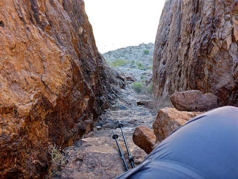
I then began working my way across several deep & steep washes into a canyon. (From the parking area it looks impassable, but is not.) The mountains to the sides of the canyon were sheer: Literally straight up. Quite beautiful. ![]() Unfortunately, I did not spot any mountain sheep or mountain goats. I worked my way up to a saddle, then down into another canyon. As I approached Hidden Valley Tanks, I geeked at spotting two arches very high up to my left. I guessed they were a quarter mile away, so I don’t think either of them is Arch 2, which is .75 miles away. That means both are unlisted.
Unfortunately, I did not spot any mountain sheep or mountain goats. I worked my way up to a saddle, then down into another canyon. As I approached Hidden Valley Tanks, I geeked at spotting two arches very high up to my left. I guessed they were a quarter mile away, so I don’t think either of them is Arch 2, which is .75 miles away. That means both are unlisted.
On three occasions I heard a very small engine above my head. Too small for a plane. I looked, but did not see anything. I figured it must be a Border Patrol drone. I was half expecting agents with guns to meet me when I exitted Hidden Valley.
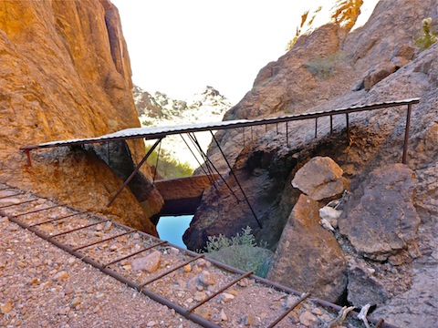
Hidden Valley Tanks had water, but being in a slot with steep walls, I did not think I could safely make my way around the pool of unknown depth. I certainly did not want to try walking across the corrugated “roof”. Bummer. I retreated back to the saddle, eventually making my way back to the trailhead at 1:50 p.m.
It was quite toasty out — my car said 83° — and with almost zero shade, so we stopped at the snack bar for a post-hike adult beverage. No beer. Bummer. (The owner said a shop has to be open 12 months a year to legally sell alcohol, tobacco or gasoline. ![]() ) The 32 oz. ice tea, however, was ice cold and the mountain of curley fries has to be seen to be believed. Honest, it looked like a small block V8, and just as greasy, but oh so delicious!
) The 32 oz. ice tea, however, was ice cold and the mountain of curley fries has to be seen to be believed. Honest, it looked like a small block V8, and just as greasy, but oh so delicious! ![]()
If you look to the right as you head north from the snack stand, you can see an arch. It appears to be the mapped Arch 2, not either of the unexpected arches.
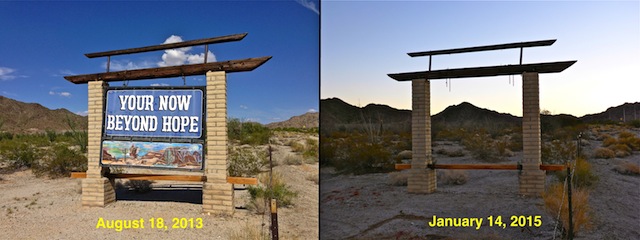
To avoid I-10 rush hour in Phoenix, we drove back on U.S. 60. The “Your Leaving Hope” sign is back up … ![]()
Note: 13 months later, I completed the loop. Great hike. Highly recommended!
GPS File: Castle_Dome_Arches (This visit’s route.)
Distance: 5.15 mi.
AEG: 872 ft.
Time: 2h 35m
Hike Video
Arches: Castle Dome Mountains from Preston McMurry on Vimeo.