

With five of the six national forests closed in Arizona until at least September, finding a hike — let alone nine! — in Arizona that is under 100℉ calls for desperate measures. In this case, hiking trails that are more suited to dog walkers, families with young kids, or casual bike riders.
The punishment for violating a forest closure is a Class B misdemeanor which carries a $5,000 fine and up to six months in Federal Pound Me in the Ass Prison. In my younger days, I was a guard. I like going home at night and eating baloney that is not rainbow-colored. 🤢
So, my plan the next two months is to hike the Iron King Trail, Willow Lake, Peavine Trail and Watson Lake in Prescott; Buffalo Park and the Rio de Flag in Flagstaff; Clam Bed and Red Basin in the Petrified National Forest; and a big loop in the Chiricahua National Monument. (Interestingly, national parks — even those adjacent to a closed forest — are still open.)
Iron King Trail is a rail trail , which is an old railroad bed with the rails and ties removed to create a smooth, nearly flat, multiuse recreation path. Officially, Iron King Trail is the four extant miles of the Prescott East Railroad, which operated in the early 20th Century between Entro, Yeager, Dewey, Humboldt, Poland Junction and Mayer.
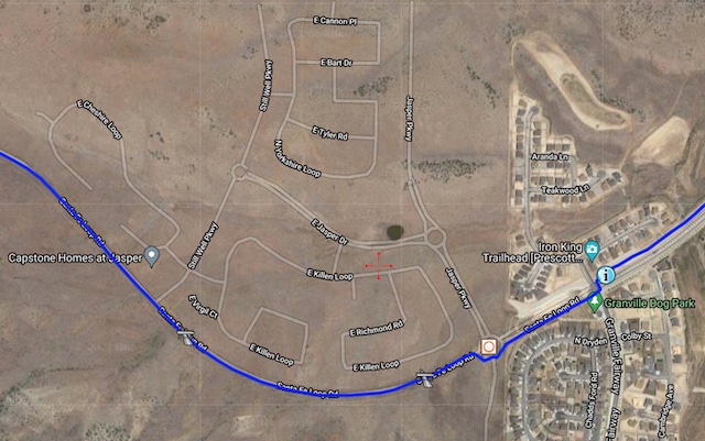
Because Prescott Valley (fka Yeager) is a metastasizing suburb of metastasizing Prescott, it is gradually encroaching even upon Iron King Trail: The first mile is now a sidewalk, and only three trailish miles remain. I started hiking at 7:15 a.m. from the traffic circle at Santa Fe Loop Rd. and Jasper Pkwy., which is actually “no parking”. (I jumped out, and my wife drove off.) 🚧
A popular trailhead is catty corner from the Granville Dog Park, on the northeast corner of Granville Fairway and Santa Fe Loop Rd. I saw a bunch of non-construction vehicles there, but it does not strike me as the sort of place that will remain legal once the community is built out. If you don’t mind cement walking, park back at Santa Fe Station Park on the southwest corner of Santa Fe Loop Rd. and Glassford Hill Rd.
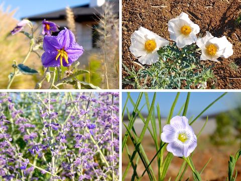
Clockwise from upper left: silverleaf nightshade, southwestern prickly poppy, Lewis flax, and planted Russian sage.
From Granville Fairway, hiking Iron King Trail to Peavine Trail & back is 6.5 miles, 200 AEG (accumulated elevation gain). If you “hike” the sidewalk from Santa Fe Station Park, the out & back to Peavine Trail is 8.0 miles, 250 AEG. Options include heading north or south on the Peavine Trail, or exploring the Granite Dells.
It was only 65℉ when I started hiking, but quite humid due to Prescott Valley getting a ½” of rain the day before. It was a toasty 87℉ when I finished only three hours later. 🥵
The first half mile of actual rail trail (as opposed to sidewalk), is adjacent to hundreds of houses in various stages of construction. The next half mile, to the first rail car, is site preparation for even more construction. That first mile west of the Jasper Pkwy. traffic circle is where all the flowers are located: plenty of silverleaf nightshade, a fair number of southwestern prickly poppy, Lewis flax, and several landscaping species.
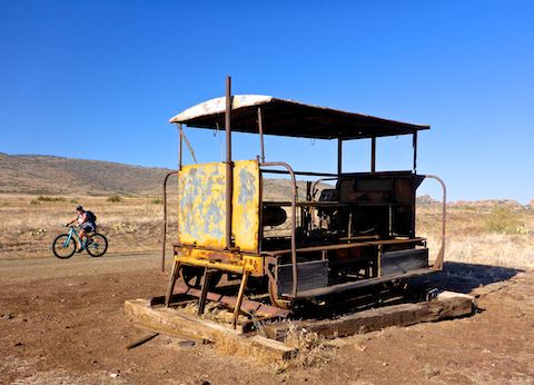
I’d heard that the rail cars marked every mile of Iron King Trail, but that is no longer quite the case: Yes, there are rail cars at milepost 2 and 3, but none at milepost 1 by the traffic circle, and there is a third one at milepost 3.4 (perhaps moved from milepost 1?). It looks like the rail cars were used to move maybe a half dozen people, or pull light loads between stations. The one I looked at closely had a 12 volt battery and what appeared to be a truck engine. 🚂
Though not at Piestewa Peak traffic levels, there was steady traffic all along Iron King Trail: Hikers, dog walkers, trail runners, and mountain bikes. Unlike Phoenix, everyone was at least polite, and many friendly. The bikes all safely passed. There was less traffic on the short part of Peavine Trail I hiked, but I did see a horse rider there.
The first 2¾ miles from Santa Fe Station Park, or 1¾ from the Jasper Pkwy. traffic circle, are totally exposed. No shade. It is only when the Iron King Trail begins entering the Granite Dells its final 1¼ miles that there is occasional spot shade. Conversely, the last hour of your hike will be in the blazing sun.
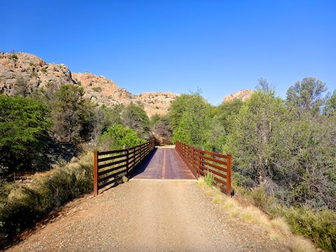
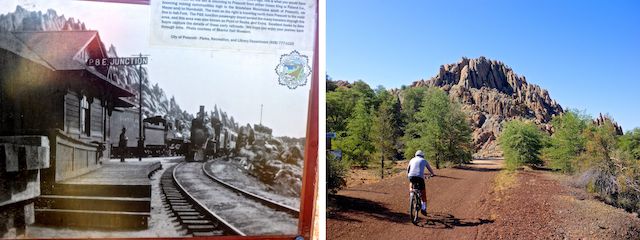
The Iron King Trail ends at the old Entro siding on the Peavine Trail. (Of which nothing remains.) There’s a portapotty, a picnic table and several historical signs — which I took time to read as I was for once far ahead of schedule.
“No trespassing” signed barbwire fences parallel both sides of the Iron King Trail from the Jasper Pkwy. traffic circle all the way to Entro, then again north along Peavine Trail. I’d been hoping to do some exploring northeast of Entro, around Hill 5630, and checkout the Boblett Cemetery, so that was a bummer. Hopefully the land eventually transfers to park land, not destroyed by developers. 👋
I barely stopped on my way back along the Iron King Trail, making the four miles to Santa Fe Station Park in only 75 minutes.My average moving speed for the day was 3.2 mph. On the way back down I-17 towards Phoenix, the Tiger Fire west of I-17 had grown considerably, but thankfully not enough to close the freeway. I love being home before noon!
Directions: From Phoenix, head north on I-17 to Exit 262. Head west for 21 miles on AZ-69. Turn right on the Fain Rd. beltway. In 7.2 miles, stay left on the beltway, which becomes AZ-89A. In 2.0 miles, take exit 322 right, then turn left onto Glassford Hill Rd. Santa Fe Station Park, in 1.4 miles on the right, does not currently show on sat view, so if you don’t see it on your GPS turn right onto Santa Fe Loop Rd. and park in the dirt in 0.7 miles on the right.
GPS File: Iron_King_Trail
Distance: 8.09 mi.
AEG: 214 ft.
Time: 2h 31m
Hiking Video
Iron King Rail Trail, Prescott Valley from Preston McMurry on Vimeo.