

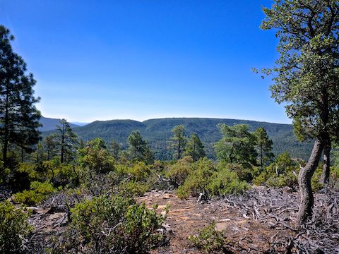
Nash Point, is located on the Mogollon Rim, above the hamlet of Strawberry, just west of AZ-87. South, Nash Point is flanked by Strawberry Valley, Hardscrabble Mesa and Deadman Mesa. North, by Fossil Creek Canyon — views of which are this hike’s main attraction.
Nash Point is named after Henry W. Nash, a miner and ranch hand who also taught at the one-room Strawberry School in Arizona’s terriorial days. Buckey O’Neill — famous as the Yavapai County sheriff — was at the time Nash’s school superintendent. Nash would go on to serve under O’Neill in Teddy Roosevelt’s Rough Riders, before dying in the Phillipines in 1902. 🇵🇭
The hike to Nash Point is a straightforward 2½ mile stroll west on FR 9365R from AZ-87, with 570 ft. AEG (accumulated elevation gain). There aren’t any hiking options, other than a moderately strong hiker could hike it off trail. An SUV could drive as far as Nash Tank, ¾ mile west, but it’s already a short hike, so why bother?
I thought it would be a bit different if I did my video intro as I pulled off AZ-87 into the FR 9365R trailhead. (Currently a road work staging area, complete with portapotty.) Unfortunately, I later found out the dashcam file was corrupted, forcing me to record the intro at home. That’s what I get for not doing multiple takes, like I normally do.
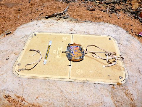
I started hiking west on FR 9365R at 8:45 a.m. I was surprised to find an electrical access panel cemented into the ground. (I found four or five more, one with an above ground metal box, at least one open.) Curious why, as the Nash Point mesa is Coconino National Forest, not private land ripe for development. 🤔
While doing pre-hike satellite recon, I’d noticed several short jeep trails south off FR 9365R, to the rim overlooking Strawberry. Nothing really interesting at any of them, just old campsites and garbage. Nice views south though, particularly of Milk Ranch Point and Strawberry Mountain. Even Four Peaks was visible, 50 miles away.
I found two cattle tanks along FR 9365R, one south of the jeep trail, one right next to it. Apparently the later is named Nash Tank, though that it is not shown on the topo. On satellite view, Nash Tank has water, but when I passed by it looked like it had not seen water in years.
There were plenty of large, billiard table flat, sitting rocks along FR 9365R. There was also some spot shade. But the two rarely coincided. The vegetation was pine, manzanita, juniper, something that looked like juniper but had deciduous leaves, and small meadows of dry grass. The only cactus I remember were twistspine prickly pear which dotted the grassy areas. 🌾
After Nash Tank, at ⅔ mile, FR 9365R starts descending. The views southwest open up, particularly to Hardscrabble Mesa and Deadman Mesa. The jeep trail gets rocky, but still okay for hiking. After 1⅓ miles, there is a split in the trail: Left is obvious, so that is the way I went. It is also wrong. Go right, the non-obvious way. It clears up in 100 yds. After 250 ft., the descent bottoms out at a very old gate.
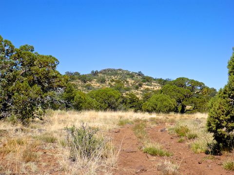
From the old gate, FR 9365R climbs 250 ft. in ⅔ mile to the base of Nash Point’s knoll. The knoll is a 30 ft. high jumble of boulders. I may be easier to scramble up from the north, but I didn’t realize it at the time, and in any case wanted to search for cliff top views of Fossil Creek Canyon.
Working my southwest from FR 9365R was easy, but slow as I kept an eye out for snakes. (The only wildlife I saw on Nash Point’s mesa was the tail end of a sprinting bull elk.) As I turned the south slope of the knoll, and began heading northwest, the brush got a lot denser. Surprisingly no cat claw, but I did get my hat knocked off several times. 🧢
My OP was at the top of a steep & narrow draw. I had a good view, but the best views (and good places to sit), were too sketchy for me. From the OP, I bushwhacked back through the foliage, then climbed 250 ft. up to the south end of the Nash Point knoll.
The 30 ft. scramble to the summit of Nash Point is not difficult — there’s never more than a five foot stretch — but beware the many cracks & gaps that could trap a foot and snap a leg bone if you lose your balance. Be careful. 🚑
Once on top of Nash Point, the view of Fossil Creek Canyon was not all that different from the OP: Still beautiful and expansive. But the summit did give a better perspective of other distant mountains, mesas and canyons. (None of which I could identify.)
It was getting quite toasty, so I wasted no time booking back to the trailhead. My hike concluded, my wife and I headed down AZ-87 into Pine for some cold beers and tasty wood-fired pizza at Old Country Inn: Meat Pie for her, East Coast Clam for me. 🤤
Directions: You could take AZ-87 north from Phoenix, but due to the trailhead being located on a descending curve, I recommend taking I-17 north, then AZ-260 east. When you reach the end of AZ-260, turn right on AZ-87. Just past five miles south, you will see a yellow 40 mph left curve caution sign. Slow down. In 200 yds., just feet past the MP 273 sign, there is a gap in the right-side railing. Turn in there and park.
GPS File: FR_9365R_to_Nash_Point
Distance: 7.83 mi.
AEG: 831 ft.
Time: 3h 16m
Hiking Video
Hiking Nash Point, Mogollon Rim from Preston McMurry on Vimeo.