
")
Counter-clockwise from Bronco Trailhead, this is the 26th segment of the Maricopa Trail.
My goal the past five years has been to hike or bike all 245 miles of the Maricopa Trail. (Four years ago, a guy actually did the whole thing in one shot, finishing in just under 70 hours — which remains the Maricopa Trail FKT.) Generally speaking, I did one segment every winter month, working my way counter-clockwise around the Phoenix metro area.
I could have hiked this Maricopa Trail segment last fall, after the summer temps moderated, but I wanted to wait until spring, so there would be flowers. Afterall, when I hiked from Bartlett Dam Rd. to FR 1058 a year ago this week, I found at least sixteen flower species. But Maricopa County has had a very dry winter, so I was expecting my 2025 run of bad flower luck to unfortunately continue. 🙏🏻
My shuttle-driving wife could not drop me off where the Maricopa Trail crosses FR 1058, because Sears-Kay Ranch legally blocks the Tonto National Forest road. I was going to start at a pullout just above the ranch gate, where another car was already parked. (I assumed hiking down to Camp Creek Falls.) After I parked, the reclining driver peeked out. Seemed shady, so we left. I started from the powerlines.
I could have crossed the Sears-Kay Ranch on FR 1058, like I did a year ago. But now that I know it is private property, I wanted to be a good boy. A ¼ mile from the powerlines, I diverted down a small, sandy, wash. The last 100 yds. were a bit scrambly, but not bad. I then skirted the ranch’s southern edge, following lightly flowing Camp Creek downstream. In 250 yds., I turned left / east up a side wash.
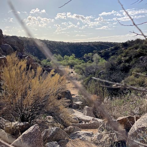
The second wash is wide, sandy, and obstacle free. I saw ATV tracks most of the wash’s half mile length. 1⅓ miles into my hike, I arrived back at FR 1058. The distance between trespassing Sears-Kay Ranch, or following my diversion, is negligible. Maybe an extra hundred yards. In 300 yds., FR 1058 intersects the Maricopa Trail. (Which is where the below hike video, begins.) 📽
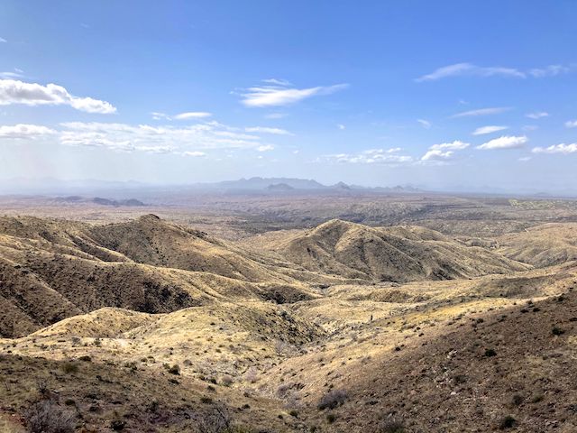
The Maricopa Trail starts wide, climbing a relatively straight 200 ft. north in a half mile. The trail then bends northeast, narrowing to single track, working the contour line to the first saddle. At just under a mile, the 300 ft. overall climb is a good warmup for the next climb. Make sure you take time to look back, the view is spectacular!

From the first saddle, the Maricopa Trail drops 230 ft. in a half mile. At the canyon bottom, there is a good sitting rock, with a bit of shade. (The trail is otherwise exposed.) I found my very first wildflower of the spring — a single cluster of Gooding’s verbena. It may not have been much, but I was ecstatic.
The Maricopa Trail follows the canyon bottom for 200 yds. Then the second climb begins, 800 ft. in just over a mile. It blew my mind that two mountain bikes rode this trail. I saw the tracks. (I don’t think it was 125s, as motorcycles are verboten.) Up or down would be equally nuts. Heart attack, or plummeting off a cliff, I’d die either way. Me? I hiked it slow & steady, appreciating the scenery. 🥜
The second saddle marks four miles on my route; 2½ from FR 1058. At 4,240 ft., it is the high point of the final Maricopa Trail segment. Along the I-17 corridor, snow was predicted down to 4,500 ft. Though sunny, strong winds were pushing heavy clouds east, towards me.
Without climbing to warm me, I figured I should put on my hoodie. I’d left it at home. This was not ideal. I had packed a trash bag “raincoat”, so I donned that instead. Improvise, adapt & overcome. 💪
The trail drops 660 ft. down canyon to the powerlines, which Maricopa Trail has crisscrossed since Taliesin West, on segment #21. The Camp Creek cabins and FR 24 are just below. The powerlines are four miles from FR 1058; 5⅔ on my route. A third of the way down canyon, I found more Gooding’s verbena, some closed up fleabane, and even a couple of desert globemallow. My cup runneth over.
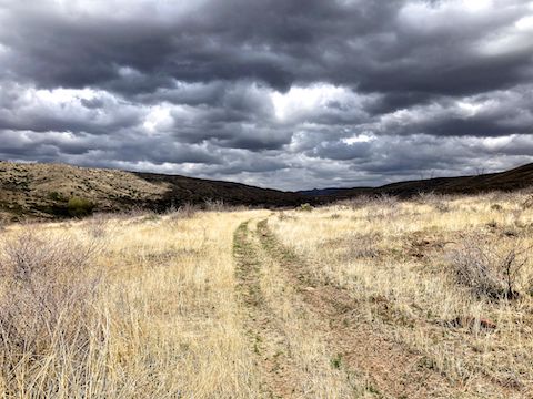
With 1,550 ft. accumulated elevation gain (AEG) in the books, I thought I would stroll the next four miles to Bronco Trailhead. Instead, the Maricopa Trail’s final miles were a constant fifty feet up, cross a spur, fifty feet down, cross a wash. It wasn’t bad, but it adds up. Though not a powerline road, the route was mostly doubletrack, roughly paralleling FR 24 and Camp Creek.
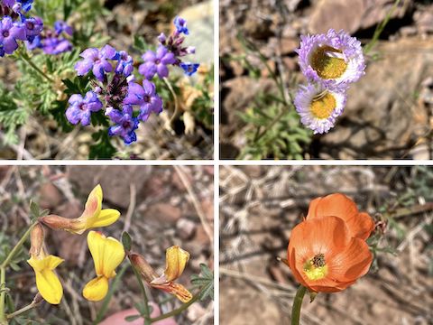
I seemed to recall there was some sort of interesting object back up canyon. I actually found it — a metal bridge — little less than five miles from FR 1058; ~6½ miles on my route. The bridge spans a short, narrow, slot canyon (really more of a wash). I spotted a single desert paintbrush (Castilleja chromosa) clinging to the “canyon” wall. It was 11:30, so despite the ever darkening clouds, I took a lunch break.
I spotted two small clusters of red & yellow pea flowers over the next hour. I caught a few raindrops, but the heavy rain held off. Under my field-expedient “raincoat” I was soaked, but it was from sweat. (Plastic having no breathability.) And it was still chilly & windy. I was hustling to finish the Maricopa Trail before the sky let loose. 🙄
I arrived at Bronco Trailhead at exactly 1:00 p.m. Before my Dad passed away two years ago, he had given me a special hiking beer: a wood-encased, Jim Beam barrel-aged Budweiser. I’d always intended to celebrate completing the Maricopa Trail by drinking it. Or maybe champagning it on my head. But it was so chilly, I just bailed. Good thing too, as it started raining on the drive back down FR 24.
FR 1058 Trailhead: From Loop 101 / Pima Freeway, take exit 36 north onto Pima Rd. Head north for 12.1 miles. Turn right on Cave Creek Rd. Pass by Bartlett Dam Rd., after which the road becomes very twisty. Mind your speed. Also, note the green MCDOT mileage markers. Between MCDOT 2 and 3, FR 1058 will be on your right. Park under the powerlines. Beware of old fire rings, which have many nails.
Bronco Trailhead: From FR 1058, continue north on FR 24. In two miles, the road turns to car drivable dirt, back to pavement by the Camp Creek Cabins, then back to dirt again. Bronco Trailhead is at MCDOT 8, on the left.
GPS File: Maricopa_Trail_FR_1058_to_Bronco_Trailhead
Distance: 9.86 mi.
AEG: 2,010 ft.
Time: 4h 07m
Rumble Video
Vimeo Video
Maricopa Trail: FR 1058 to Bronco Trailhead from Preston McMurry on Vimeo.