

I was on the Mogollon Rim two weeks ago, hunting fall colors in Merritt Draw & Maverick Canyon. With a big cross country drive coming up in a few weeks, I was not relishing the thought of too much additional driving.
Also, I tend to avoid hiking near Sedona, as it is a traffic nightmare, having decades ago outgrown the ability of the one road through town’s ability to handle what is now urban traffic, never mind hordes of tourists. No thanx. (The last time I hiked Sedona was Brins Mesa in 2017.) It may not be obvious from my Phoenix Asshole Drivers dashcam videos, but I try to avoid stress if at all possible. But I do like to hike. 🧭
So, I hit on the idea of doing a hike west of Sedona, but north of the bajillion traffic circles in Cottonwood. That hike is Loy Canyon Trail #5.
Loy Canyon is in the Red Rock-Secret Mountain Wilderness of the Coconino National Forest. It is a roughly 10-mile long canyon that descends between Secret Mountain and Loy Butte, south past Hancock Ranch, through a web of OHV trails, to Windmill Ranch, just north of AZ-89A.
Loy Canyon Trail #5, starts at the Hancock Ranch, just east of the Honanki Ruins on FR 525. The well-defined trail heads north five miles, up canyon, to the saddle overlooking Secret Canyon, at the junction with Secret Mountain Trail #109. (The Secret Mountain Trailhead, at the end of FR 538, is accessible by driving southwest from Flagstaff on FR 231, past Rogers Lake.) 🏞
Loy Canyon Trail #5 follows the original path trampled by Samuel Loy’s cattle in the 1880s, as he herded his cattle between their winter pasture at the bottom of the canyon, and their cool summer pasture at the top.
Loy Canyon Trail #5 is just a single trail, straight up canyon, so the options depend on where you turn around, or which direction you go when you get to the saddle. Besides the Honanki Ruins, there are other cliff dwellings and petroglyph sites scattered along the upper reaches of Loy Canyon’s walls, if you are comfortable off trail, and know where to look.
- To Sandstone Alcove: 6.0 miles, 600 AEG (accumulated elevation gain), total round trip.
- To Switchbacks: 8.0 miles, 800 AEG, total round trip. ✅
- To Saddle: The final mile is steep, with no shade. 10.0 miles, 1900 AEG, total round trip.
- North to Hidden Cabin: Add 3.0 miles, 300 AEG, round trip, to option #3.
- Secret East Trail #114: Add 2.8 miles, 300 AEG, round trip, to option #3.
- Secret Mountain Trail #109 to Secret Cabin: Add 2.3 miles, 500 AEG, round trip, to option #3.
- Trail #109 to the End: Would be a very long, strenuous, day from Hancock Ranch. Add 7.5 miles, 1300 AEG, round trip, to option #6.
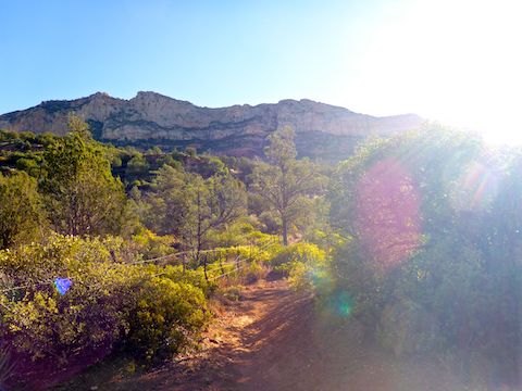
Loy Canyon Trail #5 by heading east along the Hancock Ranch fence line for 150 yds., before turning northwest, still following the fence. The fence is down in many spots, but do not think about crossing it, as the ranch dog will bark at you even while you are on the trail. I did not detect the presence of any cattle (i.e. no cow pies).
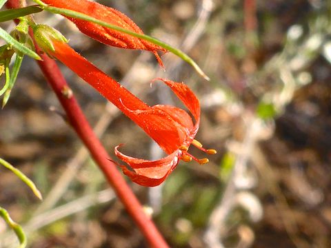
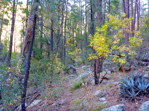
The first ½ mile of Loy Canyon Trail #5 is through typical desert scrub. The next 3½ miles, to the foot of the switchbacks, has mostly pretty good shade throughout the day, provided by juniper, scrub oak, and shorter pine lower in the canyon, with the trees getting taller the further up canyon you go. After a dry summer monsoon, flowers were scarce. 🌲
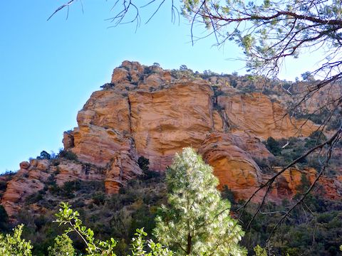
The best red rock photos were on the west side of Loy Canyon, partly because the canyon wall is closer to the trail, and partly because the sun is not backlighting it. The trail passed within feet of several interesting rocks, the first a red sandstone alcove, the second a lichen-spotted number at a wash crossing. All the wash crossings were bone dry.
The further Loy Canyon Trail #5 goes, the canyon walls start changing from smooth orange sandstone to jagged cream limestone.
When I reached the foot of the switchbacks, briefly considered heading up to the saddle. Instead, I figured I’d save the Secret Mountain-top trails for a drive down FR 538 from Flagstaff. After swapping water bottles, I headed back down Loy Canyon. On the way back to the trailhead, I took a lunch break back at the sandstone alcove. No vinegar chips, because for some reason the Sunnyslope QT had been out. 😢
On the drive back home, we saw a big, dark, smoke column that from our angle was rising over I-17 at Black Canyon. “Thankfully”, rather than being the daily I-17 blockage, it was the Horse Fire, a new fire start deep in the Bradshaw Mountains.
Directions: From Phoenix, head north on I-17, the Black Canyon Freeway, to Exit 293. (Google Maps recommends getting off on AZ-260 in Verde Valley, but then you have to negotiate traffic and a bajillion roundabouts in Cottonwood.) From Exit 293, head west on Cornville Rd. for 12.7 miles. Turn right on AZ-89A. In 7.1 miles, turn left on to dirt FR 525 / Loy Butte Rd. In 9.5 miles, just before Hancock Ranch, park at the trailhead on the left. FR 525 starts out smooth, but gets rougher the further you go. I saw cars at Hancock Ranch, but they were crawling, and I would not recommend it.
GPS File: Loy_Canyon_Trail_5
Distance: 8.39 miles
AEG: 1,064 ft.
Time: 3h 09m
Hiking Video
Hiking Loy Canyon, Coconino National Forest from Preston McMurry on Vimeo.