

The first stop in this year’s fall color tour is the San Francisco Peak’s Inner Basin.
The San Francisco Peaks are the remains of a stratovolcano overlooking the city of Flagstaff. Scientists are not sure if the original stratovolcano disappeared over a series of eruption & erosion cycles, or in one massive bang that would have dwarfed Mount St. Helens’s 1980 cataclysm. Whatever happened, happened between 1,000,000 and 400,000 years ago. 🌋
The San Francisco Peaks are the only stratovolcano in the San Francisco Volcanic Field, which covers 1800 sq. miles, mostly in the Kaibab and Coconino National Forests. There are more than 600 volcanos in the field, with the oldest being near Williams, growing progressively younger as you head 50 miles east. The youngest volcano is Sunset Crater, in the middle of the field, just across US-89 from the San Francisco Peaks. Sunset Crater erupted in 1064 A.D.
Inner Basin, the high point in the San Francisco Peaks’s caldera, is well known for the fall color of its quaking aspen, which peak in early October.
Even though I lived in Flagstaff for five years in the 1980s, I had never been to the Inner Basin. In recent years, on our Flagstaff fall romantic getaways, I nibbled around the edges of the San Francisco Peaks, hiking the Abineau-Bear Jaw Loop and the Weatherford & Kachina Trails. But never Inner Basin.
Hiking Inner Basin Trail #29 from Lockett Meadow to the Inner Basin itself is only 2.7 miles, one way, with a decent 1,200 ft. accumulated elevation gain (AEG). A 5.4 mile roundtrip was not enough payoff for a 3+ hour drive from Phoenix, no matter how vibrant the fall folor. So, I looked at other options. 🤔
Summiting Doyle Peak from Lockett Meadow would be a 11.6 mile, 3,500 AEG, roundtrip. A bit much for this middle-aged fat man, considering the elevation ranges from 8,600 ft. to 11,460 ft.
I decided instead to emphasize the fall color, and put together a decent length loop that would give me a variety of angles on Lockett Meadow, the Interior Valley and Inner Basin. (See the GPS route below.)
Driving up I-17 from Phoenix, the top of the San Francisco Peaks was obscured by clouds. Visually, it looked like someone had lopped of the peaks with a sword. 🗡
The dirt road from US-89 to Lockett Meadow was a bit bumpy, but not too bad. At 8:30 a.m. on a fall Friday, there was only one or two vehicles ahead of us, and only one headed back down. At 2:30 p.m., on our way out, there was a steady stream of traffic headed up. Saturday and Sunday, in the fall, the U.S. Forest Service restricts traffic to a maximum of 100 vehicles at a time: No one gets to go in until someone else leaves. So, my recommendation is to visit the Inner Basin on a weekday. 😉
It was a bit windy & chilly at 8,600 ft. in Lockett Meadow. Luckily I had thought to bring the hoody with me that I bought at the Family Dollar in Bouse a few years ago. It’s thin, but even one thin extra layer can make a big body heat difference!
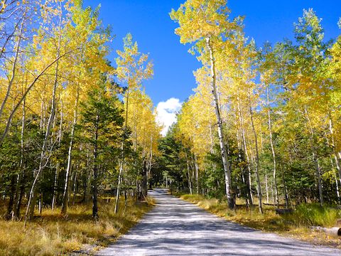
We parked at the pit toilet on the edge of Lockett Meadow, but the actual Inner Basin Trailhead is at the end of a short loop road. Just between the meadow and the trailhead there was already great fall color, and easily accessible for non-hikers.
I checked out the info kiosk at the Inner Basin Trailhead, then backtracked a hundred yards to a gated, unnumbered, jeep trail. I folowed that jeep trail for 1.5 miles to the intersection of Waterline Rd., where it reconnected to Inner Basin Trail #29. The color in there was decent, but most importantly, I was away from other people.
At Waterline Rd., there were about a half dozen locked buildings. I saw a sign that they were for avalanche control. Maybe that’s where they hide the snow cannon?
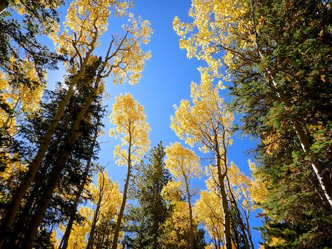
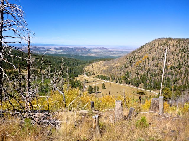
From the Waterline Rd. intersection, I again veered off Inner Basin Trail #29, opting for a continuation of the old jeep trail I had been on. Split right to follow my route; left to stay on Inner Basin Trail #29. There was some really good fall color, cheddar-colored quaking aspen, some of which framed Doyle Peak and Fremont Peak. After ⅔ of a mile, rather than continue up Beard Canyon to Bear Paw Spring or Flagstaff Spring, I turned left / south.
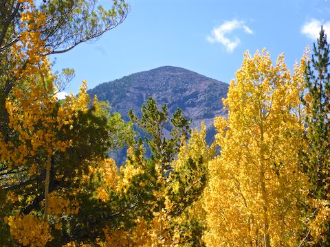
After turning south, it is another ⅓ of a mile to Inner Basin. About halfway there is a side jeep trail that accesses Flagstaff Well #14, where there is also a quite extensive weather station. The meadow also has a good fall color-framed shot of Humphreys Peak. 🏞
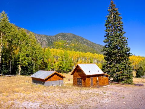
There is another pumphouse — Flagstaff Well #9 — at Inner Basin. There is also a small two-person shelter, with the back facing up canyon, from where the wind was blowing hard. I saw quite a few people bundled up, but I soldiered on in only my hiking shirt. Other than my ears, body heat compensated.
I continued up Inner Basin Trail #29 for another half mile, so I could say I made it to 10,000 ft. altitude. Then I doubled back down Inner Basin to weather shelter … which was still occupied. Bummer. Instead, I took a break on the leeward side of the pumphouse.
From Inner Basin, I took Trail #29 back to Waterline Rd., passing Flagstaff Well #11 along the way. The color was only okay in that ¾ mile section, but a couple of Chinese tourists were sure enjoying it. 📸
Inner Basin Trail follows Waterline Rd. east for a hundred yards, before turning north. I continued east on the road, through the cathedral of quaking aspen. (Still only key lime-colored, but beautiful nonetheless.) There were quite a few bits of broken ceramic pipe along the road.
There is a gate just before Waterline Rd. changes from quaking aspen to grassland, 1.4 miles east of the avalanche buildings. Just past the gate is a well-defined, but unnumbered jeep trail to the left. The jeep trail is not even on the topo, though it is obvious on satellite view. It parallels a small ridge as it descends north to FR 553 at the foot of Sugarloaf Peak.
The jeep trail had great views southeast towards Flagstaff’s outskirts, and east towards O’Leary Peak and Sunset Crater. The ridge top was only 100 ft. up. Though the ridge did not have the panoramic fall color view I had hoped for, it did have a great view north to SP Crater, Colton Crater and other volcanic formations on the Babbitt Ranch.
There were some small lupine along the jeep trail, nearly the only flowers I saw all day. (I saw one closed up Arizona Thistle and one purple daisy-like bloom: That’s it!) The top of the ridge had some dry grassy plant with a seed-filled pod that rattled when I brushed against it. I jumped a few times, before figuring out it was not snakes. 😏
At FR 553, I turned west returning to Lockett Meadow. There was some final good fall color in that short stretch between Sugarloaf Mountain and the meadow. You can see it in the walking outro to my hike video, below.
It was another good day on the trails. Next week: More fall color on the Mogollon Rim!
Directions: From Flagstaff, head north on US-89. 11 miles north of the Flagstaff Mall, at the Sunset Crater sign, turn left onto dirt FR 552. (Right goes to Sunset Crater.) In 0.6 miles, turn right on Schultz Pass Rd. Follow the Inner Basin signs 4.5 miles to the Inner Basin Trailhead. The route is car drivable, but bumpy, twisty and narrow. Keep speed below 20 mph, and beware oncoming traffic.
GPS File: San_Francisco_Peaks_Inner_Basin
Distance: 8.71 miles
AEG: 1,639 ft.
Time: 3h 35m
Hiking Video
Fall Color: Lockett Meadow & Inner Basin from Preston McMurry on Vimeo.