

Fall color on the San Francisco Peaks … uh, peaks … during the last week of September / first week of October. Lockett Meadow is at 8,600 ft. el., so I figured the 9,500 ft. el. hills surrounding Greens Peak would have great fall color at the same time, maybe even a few days earlier.
Leaving Sunnyslope at 6:00 a.m., my non-hiking wife & I made good time to Pinetop-Lakeside. Continuing on AZ-260, as it climbs across the White Mountain Apache Reservation, I was not seeing any fall color. Hints of lime at most. I was really hoping for something spectacular, and was already suspecting the worst. Oh well: In for a penny, in for a pound. 💷
The FR 117 turn was obvious, as the antennas on Greens Peak had been visible for several miles. It was such a pleasant drive, I was tempted to skip the hike and follow FR 117 all the way to AZ-60. Especially after discovering my intended trailhead across FR 117 from Greens Peak was a wildlife habitat area. (Specifically for Mexican gray wolves.) FR 117 would make a good “off-roading” video.
I hiked the Greens Peak loop counter-clockwise. I started walking north at 10:30 a.m. on FR 117, which was lined by scattered western yarrow, harebell and mostly flowerless mullein. Greens Peak’s summit, with the fire lookout and hints of yellow, was briefly visible. In a ½ mile, just short of MP 11, I turned left onto FR 8674.
I skirted a campsite just around the corner, in case any unleashed dogs might take offense at my passing. Thankfully, Cujo was as absent as his people. FR 8674 climbed slightly for ⅓ mile, through alternating meadow and pine shade, to a low tension powerline. To the left, the powerline climbed to Greens Peak’s summit. To the right, the powerline followed FR 8674, which turns right, down slope. ⚡️
I was unsure where the trail continued. If you take the uphill powerline as 12 o’clock, then the trail continues at 1 or 2 o’clock. Now a proper hiking trail, the route pitched up, climbing 300 ft. in the next ½ mile. An obvious mountain bike downhill run snaked across the trail. The forest was darker, with plenty of moss. I saw some dandelions and scraggly fleabane.
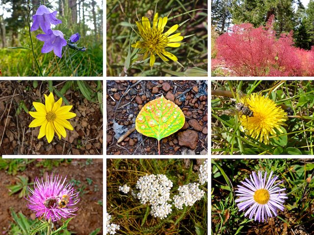
Top Row: harebell, yellow salsify, fetid goosefoot.
Middle Row: hairy golden aster, wet leaf, dandelion.
Bottom Row: Wheeler’s thistle, western yarrow, fleabane.
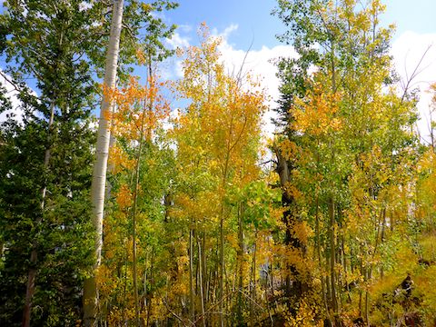
Previously unmarked, the trail reaches a spur on the northwest slope of Greens Peak, which is marked by a diamond-shaped reflector on a green metal pole. Since straight was downhill, and I wanted to go up, I turned left. The next ¼ mile was the steepest part of the day, climbing 250 ft. Many trees were marked with round red reflectors. I started to see hints of lime in the aspen.
The final ¼ mile to the Greens Peak summit continues climbing, but at a more relaxed grade. The aspen now had hints of yellow.
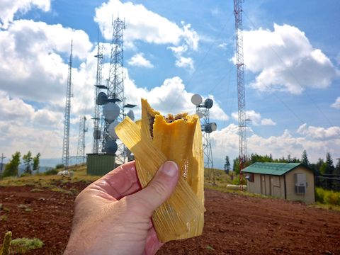
The Greens Peak summit is topped by an antenna-festooned 40 ft. metal fire lookout tower. Very solid looking, despite the high winds. There was an actual brick pit toilet — not a wood outhouse — on the trail side of the fire lookout. Just on the other side of the tower, by the top of the powerline, was a small grove of aspen with cheddar colored leaves.
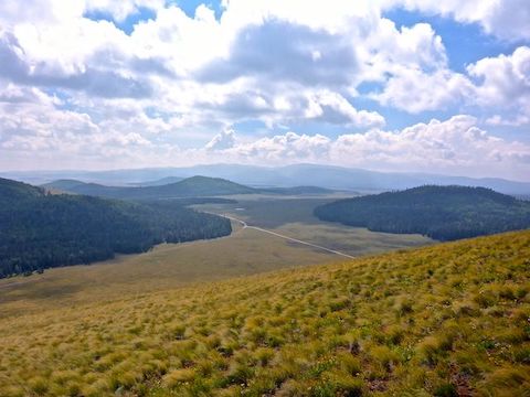
The Greens Peak summit road runs south through a fairly dense antenna farm. While the mountain’s north and east slopes are forested, its west and south slopes are grassy. As a result, and despite only being 600 ft. above FR 117, Greens Peak has 180° of great views across the White Mountains. Mount Baldy, 14 miles south, was easy to pick out. 🔭
After a short break, I started down FR 61C, the Greens Peak summit road, which had scattered harebell and hairy golden aster. FR 61C was steep, and a bit slippery, but not too rough. An SUV could probably get up it. Heading down, FR 61 was very shiney: I thought a Forest Service crew had oiled it, or something. But no, that was just the crushed granite used to surface the road.
The cattle at the abandoned roller scattered, except two which started to follow me. Maybe because I was the only intact male in the herd?
I got back on FR 117 after barely four miles of hiking. I could have easily cut across the base of Greens Peak, but figured it would save time, and give me an extra mile to stay on forest roads. Because walking cinder-surfaced FR 117 was so easy, I took the opportunity to check out some of the unnumbered jeep trails on the left / west / non-wildlife habitat side of the road.
Most of the side jeep trails off FR 117 led in a couple hundred feet to a one-spot campsite. But one trail in particular, just past MP 12, led to a campsite that seemed large enough for a scout jamboree. It actually had two porta-potties! Ironically, it also had the most fetid goosefoot. 👃🏻
I finished hiking just before 2:00 p.m. After my traditional sodium and potassium restoring V-8, I quaffed a Moose Drool hiking beer. Not that I really needed either, as I’d barely consumed two bottles of water, it was so chilly. In fact, it even snowed the next day!
Directions: From Phoenix, head north on AZ-87, the Beeline Highway, into Payson. Drive east on AZ-260 for 125 miles, through Heber-Overgaard, Show Low, Pinetop-Lakeside and the White Mountain Apache Reservation. A mile past the Railroad Grade Trailhead, will be FR 117, on your left. Turn there. In dry, FR 117 is easily car drivable dirt. Note it has white-on-green mile markers, counting down. Greens Peak is the mountain with the antenna farm. Just before MP 13, the road splits: Stay right on FR 117. In ⅓ mile, FR 117 begins descending. Park at any of the unnumbered jeep trails on your left, before MP 11. Warning: The right / east side of FR 117 is a no motorized vehicles wildlife habitat area.
GPS File: Greens_Peak_Loop
Distance: 6.34 mi.
AEG: 963 ft.
Time: 2h 32m
Hiking Video
Hiking Greens Peak, Arizona White Mountains from Preston McMurry on Vimeo.