

Heading east from Dewey, this is the first part of the 8th segment of General Crook Trail.
In 1872, General George Crook surveyed a road from Fort Apache, Arizona, west across the Mogollon Rim to Camp Verde, then on to Fort Whipple in Prescott. “Vanished Arizona: Recollections of the Army Life of a New England Woman“, by Martha Summerhayes, contains a detailed description of travel on the General Crook Trail in the 1870s. 🏜
Much of the old General Crook Trail was overlaid by Rim Rd. / FR 300 in 1928, but in 1976 the Boy Scouts established a hiking trail which followed the wagon road as closely as possible. The hiking trail is marked by gabions, cairns, blazes and mileposts. (A 24″ high log, 4″ diameter, with the mileage etched into the angled top, and painted white.) V posts mark miles east of Camp Verde.
General Crook Trail mile markers can be hit & miss, but I heard all seven from V51-V57 were still extant.
Rim Rd. / FR 300 has a road project going on. Currently from miles 36-40. (The first dirt miles west of Woods Canyon Lake.) On a low traffic mid-week before Memorial Day, the delay was 15 minutes. After showing my wife where to pick me up at FR 115, we arrived at FR 137 about 9:30 a.m.
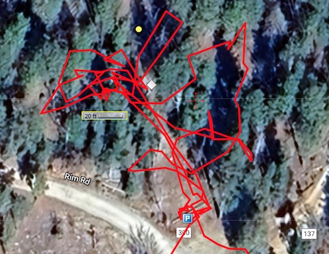
I proceeded to spend the next 30 minutes fruitlessly searching for mile marker V51. That on top of the 15 plus minutes I spent trying to find V51 at the end of the previous General Crook Trail segment. All I found was the happy face balloon. I found four more balloons before my day was done. 🤨
Arizona Conservation Corps had a crew working on next 1¼ miles of General Crook Trail past Myrtle Lake to FR 300H: Orange ground flags, pink ribbons, sawed logs, cleared tread. Their work is much appreciated, but the chevrons were mostly easy to follow. Mile marker V52 was right where I expected, and had been painted sometime since 2013.
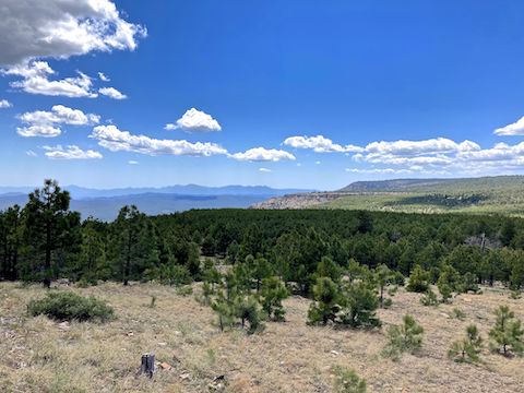
Though no longer groomed east of FR 300H, General Crook Trail was still mostly easy to follow smooth, pine needle-covered, old — original? — road bed. I saw many small patches of snow. (The overnight low was around 32℉.) To give myself the best chance of spotting mile markers, I walked slowly and scanned when I got within 200 yds. of where I expected them to be.
My strategy paid off, as I found mile marker V53 at the head of Middle Leonard Canyon, about 250 ft. west of where it was previously mapped. V53 had decent paint, but the post is decaying. General Crook Trail crosses FR 295 at Rim Rd. / FR 300. Walking out of the woods, I startled a group of eight dirt bikers. Friendly guys, but they were headed 175 miles up to Page! 😳
From FR 295, I followed Rim Rd. / FR 300 east for a quarter mile until I found a roadside chevron. I suspect General Crook Trail is inside the woods instead: It was 250 yds. to the next chevron after that, whereupon the trail re-entered the treeline. Mile marker V54 was where I expected. The V54 post was in decent shape; the paint barely legible.
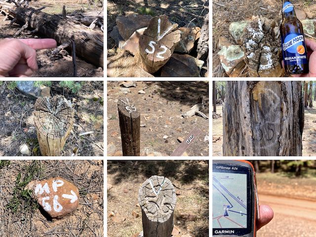
Top Row: Is this V51? V52, and enjoying a hiking beer at V53.
Middle Row: V54, V55, and original cavalry V55?
Bottom Row: V56 is that away!, V56, and where V57 is supposedly located.
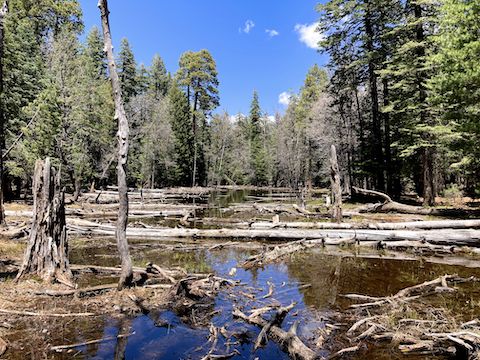
At 3⅔ miles, the General Crook Trail reaches FR 752. Turn left (north) for about 100 yds. I didn’t see a chevron marking where to turn off FR 752, nor for the next 200 yds., so you’ll want to download the attached GPS route. By the time it reaches that next chevron, the trail has again become old road bed. The trail then switchbacks down to Lake Number Four, in the upper reaches of East Leonard Canyon.
I was unaware there are 19th century cavalry wagon tracks worn into bedrock near Lake Number Four. Climbing up from the lake, mile marker V55 is 300 ft. west of where I expected. I’ve been by V55 before, and hadn’t noticed, so it was quite a surprise to turn around see V55 carved in a tree! I assume it’s an original etching since it was a tall dead tree, with the snapped off upper half laying across the trail. 🤔
A minute after crossing FR 9715J, at 4⅔ miles, I chanced upon the coolest find of the day: The Jesus Tree. Someone carved what looked like chainsaw art into a pine tree. Maybe it was Moses? From the Jesus Tree, I got on Rim Rd. / FR 300, as General Crook Trail #130 left the Coconino National Forest, and entered the Apache-Sitgreaves National Forest as renumbered General Crook Trail #140.
After passing the Sitgreaves National Forest sign, there is a cattle grate in Rim Rd. / FR 300. Drop left (north) off the road to pick back up the General Crook Trail. In 100 yds., there was a small V56 arrow rock in the middle of the trail. Mile marker V56 is maybe 20 ft. off the trail, about 300 ft. west of its prior indicated location. 🤷🏻♂️
After crossing an anonymous dry lake, General Crook Trail gets a bit confusing. I accidentally wandered off trail. Up a draw, I found a tree with a chevron, following the trail back to where I lost it. (This sort of wandering accounts for the extra three miles I hiked.) The chevroned singletrack trail — not old road bed — paralleled Rim Rd. / FR 300 eighty feet below.
As I was looking for V57, an oddity occured: I could see a chevron downslope, next to the road, but the trail, also with chevrons, continued following the contour. I stayed on trail, moving slowly. I never saw anything related to V57 actually on the General Crook Trail. Completing the segment at FR 115, I doubled back down Rim Rd. / FR 300. After searching its claimed location for 20 minutes, I gave up.
FR 137 Directions: Since this segment begins in the middle of Rim Rd. / FR 300 (MP 20 of 43), whether you drive in from the east or west is up to you. I drove in from the east, so I could show my shuttle driver where to pick me up. From Phoenix, head north on AZ-87, the Beeline Highway, into Payson. Turn right on AZ-260. In 29 miles, after cresting the Mogollon Rim, take the first left onto FR 300 / Rim Rd. In 3.2 miles, at the Woods Canyon Lake intersection, Rim Rd. changes to car-drivable dirt. 9.4 miles from AZ-260 is a t-intersection. Turn left. (Right is FR 34 to Winslow.) After 7 more miles, pass by FR 115. FR 137 is 7 miles past that.
FR 115 Directions: From FR 137, double back east 7 miles on Rim Rd. / FR 300.
GPS File: General_Crook_Trail_V51_V57
Distance: 9.46 mi.
AEG: 744 ft.
Time: 4h 03m
Rumble Video
Vimeo Video
Hiking General Crook Trail: V51-V57 from Preston McMurry on Vimeo.