

The two major trailheads for the Superstition Mountains are Peralta Trailhead to the south and First Water Trailhead to the north. Sure, there are others, but these ones get most of the action, and always have packed parking, even on week days. Other Superstitions trailheads are either remote (like Frazier Trailhead) or remote with long, bumpy, drives on rarely maintained forest roads (like Woodbury Trailhead). 🤳🏻
Because so many Superstition Mountains hikes start at Peralta Trailhead and First Water Trailhead, those hikes tend to start out the same, before branching out into new adventures. The hike from First Water to Canyon Lake is no different.
The route starts off heading south from First Water Trailhead on Dutchman’s Trail #104. In ⅓ of a mile, rather than continue south towards Palomino Mountain, split left onto Second Water Trail #236. I had intended to do my video intro at the trailhead map board, but there were too many talkative oldsters milling about, and besides I felt self-concious about it. I got far enough ahead of them that I was able to do my intro at the trail split instead.
Second Water Trail #236 crosses First Water Creek, then heads up a small canyon to Garden Valley. As it crosses Garden Valley, Trail #236 is smooth & wide. A quick & easy side adventure would be to check out the arch in the green hills to your left. Otherwise, continue northeast towards the gap between Hackberry Mesa to your left and Black Mesa to your right.
In ⅔ of a mile, Second Water Trail #236 narrows to single track, and gets rocky as it begins descending 500 ft. in 1.2 miles to Boulder Canyon. I really don’t like rocky, as it makes my feet sore, and I have to take care I don’t twist one of my bad knees. Hiking poles really help with balance. 👨🏻🦯
My first hiking pole was actually a saguaro rib I picked up at Ballantine Corral. It made such a huge difference, that I became a convert, running out that week to REI to buy actual hiking poles: A pair I still use, all duct-taped together. (I tend to maximize the ROI on my purchases or, less generously, I am a ragbag.)
About half way down the descent to Boulder Canyon, you will see a wedge shaped cliff formation to your left. That is hill x2422, not Tugboat, which is sheer all the way around.
A ¼ mile before Boulder Canyon, Second Water Trail #236 passes through a lush riparian area. That is Second Water Creek. What a coincidence! 😁
I actually lost the trail for a few hundred yards along Second Water Creek, but I doubled back to get correct data for the route attached below. (Wandering around is why my hike stats tend to exceed actual distance by about 10%.) Second Water Creek had pooling, with slight trickle in a few spots. I did not look for the spring.
Second Water Trail #236 ends at Boulder Canyon Trail #103 after 2.2 miles. Right is 3.3 miles south to the base of Palomino Mountain, left is 4.0 miles north to Canyon Lake Marina. I went left.
In a ½ mile, Boulder Canyon Trail #103 crosses over the low saddle between Tugboat and Battleship Mountain. Tugboat is the wedge-shaped butte to your left, while Battleship is the cliff to your right. (Geronimo Head is straight east across La Barge Canyon.) I met a couple of English hikers who were wondering if there was a way up Battleship. Battleship’s walls are sheer, but there is a safe route up it from the south. Where, I was not sure enough to tell them. 🇬🇧
Boulder Canyon had pooling with trickle.
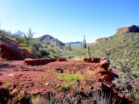
The saddle is an area known as Indian Paint Mine. It is believed a local tribe gathered pigments at the mine, but there is also a prospect and some pioneer-type stone work from an old miner’s shack. Now, it is a campsite.
After crossing the Indian Paint Mine saddle, Boulder Canyon Trail #103 turns north down La Barge Canyon, between Tugboat (still on your left) and Geronimo Head (on your right). La Barge also had pooling, but I did not see any trickle and was able to cross dry.
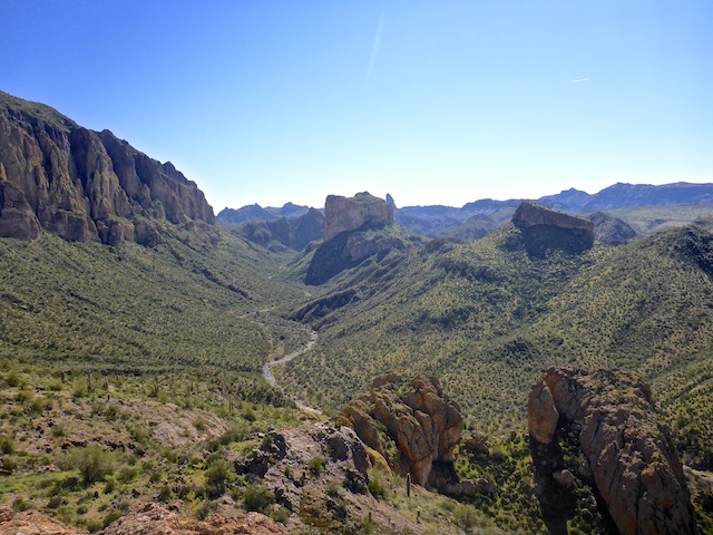
A ½ mile north of Indian Paint Mine, Boulder Canyon Trail #103 begins the only real climb of the day, 500 ft. in 0.6 miles. There’s plenty of switchbacks along the way, and the payoff is awesome views south, like the photo above. There are multiple OPs the next ¼ mile: Check them out for different angles on the Superstition Mountains’ various formations. 🏜
While taking a short break at a scenic spot above La Barge Canyon, my hiking shoes finally began delaminating. The fuzzy covering on the laces has been almost gone for ages, and the tread is so thin, my shoes are basically mocassins at this point. But hey, they were still wearable. Not if I am tripping over flapping tread, though. 25 months and 1300+ miles later … 🙏🏻
The next 1.5 miles Boulder Canyon Trail #103 winds along the ridgeline to an unsigned trail intersection overlooking Canyon Lake. The trail that continues straight is narrow with a line of small rocks across it, seeming to indicate it is no longer active. The major trail was left, so that is the way I went. I soon realized while I appeared to be on the active route, it was not the “official” trail. So, I doubled back to the intersection. Either way is fine, and left only adds a ¼ mile to your total distance. (Both routes are included in the GPS file below.)
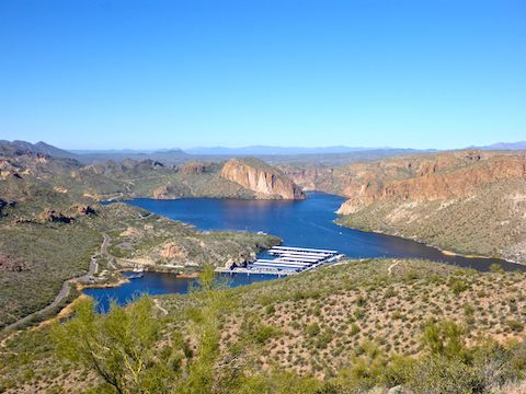
The two routes rejoin only 150 yds. from AZ-88, aka Apache Trail. The road was busy, and traffic steady across the one lane bridge over Boulder Creek, so I had to wait a minute before crossing to Canyon Lake Marina.
The hike from First Water to Canyon Lake is 7.5 miles with 1,100 AEG (accumulated elevation gain). An out & back hike, with lunch & beers in the middle at the marina’s Well Done Grill, would be a long day of 15 miles, 2,900 AEG. If you are a strong enough hiker, go for it. This old fart got a shuttle from his loving wife. A third option is a “key exchange”, where you start from one end, some starts from the other, and you exchange keys to each others’ vehicles somewhere in the middle. I talked to one hiking group that was doing that. 🔑
Despite “only” doing a shuttle hike, I still deserved a few beers, so I did my recovery while feeding bits of my chile burger to the marina’s crows & ducks.

First Water Directions: Depending on which part of the Valley you are travelling from, either take the Red Mountain Freeway / Loop 202 or US-60. If you are driving Loop 202 east, take exit 27. Go east on University Dr. for 5.5 miles, then turn left onto Apache Trail / AZ-88 for 5.0 miles. If you are driving US-60 east, take exit 196. Go north on Idaho Rd. for 2.3 miles, then turn right onto Apache Trail / AZ-88 for 5.2 miles. Regardless of which freeway you take, just past Lost Dutchman State Park, turn right onto First Water Rd. The trailhead is at the end of the road in 2.6 bumpy miles. If the First Water Trailhead is full, park a half mile back in the horse lot. Both have pit toilets.
Canyon Lake Directions: Continue past First Water Rd. for 9.3 twisty miles, crossing two single lane bridges. Canyon Lake Marina is just past the second bridge on the left.
GPS File: First_Water_to_Canyon_Lake
Distance: 8.42 mi.
AEG: 1,265 ft.
Time: 3h 40m (guesstimate)
Hiking Video
Hiking First Water to Canyon Lake, Tonto National Forest from Preston McMurry on Vimeo.