

Because it has been nine months since I celebrated Airborne Day by hiking Green Mountain Trail #21, I figured it was time for me to return to Tucson. Especially since temps in the desert were only supposed to be in the upper 70s. But then I realized I would be down in Tucson anyway for Mothers Day brunch with my mom, and I really didn’t want to make that drive twice in three days.
My next thought was to do some canyon crawling on the Mogollon Rim. But Strawberry got blasted by nickel-size hail a day ago, so I sought pastures new. 🗺
Poking around the topo in the Roosevelt Lake area, I eventually hit on the idea of hiking Cottonwood Trail #120, which is colocated with Arizona Trail segment 19. An out & back hike, Cottonwood Trail #120 climbs 1,800 ft. in a little over six miles, from the Frazier Trailhead to FR 83. (And climbs another 400 ft. on the way back ‘down’.) If you look at the elevation profile in the GPS file attached below, you will see the gain is mostly a steady 300 ft. per mile.
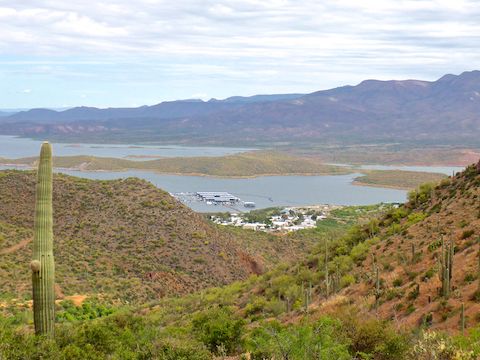
There’s nothing at the Frazier Trailhead, just east of the Roosevelt Lake Marina, other than an empty notice board and an electrical substation. (The Frazier Trail, runs 0.9 miles from the Frazier Trailhead through a tunnel, to the Frazier Recreation Area on the north side of AZ-188; there are toilets & picnic tables there.) Cell signal is okay at the marina, but spotty at the Frazier Trailhead, and non-existent in Cottonwood Canyon — despite often having line-of-sight to the marina. 🚫📱
Cottonwood Trail #120 heads south out of the Frazier Trailhead for 100 yds. before following the contour line west towards the Roosevelt Lake mobile home park. At ¾ of a mile, just before reaching the trailer park, the trail turns south, up Cottonwood Canyon.
Just after entering Cottonwood Canyon, there is a trough, that when I passed by was full. There was a rubber hose from upslope, past the trough, down into Cottonwood Creek (which was dry at that point). If the hose is feeding the trough, the connection is buried. The water didn’t look bad, but would need to be filtered to be drinkable.
At 1.3 miles, Cottonwood Trail #120 merges onto FR 341 / Arizona Trail Segment #19, at Thompson Spring. I did not bother locating the spring, but the spring box was as full of decent water as the trough a half mile back. Cottonwood Creek had slight pooling at the FR 341 crossing, which had lots of shade. 🌳
From Thompson Spring, Cottonwood Trail #120 climbs rocky FR 341 for a steep 500 ft. in only a half mile to a cattle guard. FR 341 then winds around along the contour line, through desert flora for a mile, before a short drop back to the bottom of Cottonwood Canyon, which has been rising to meet the trail.
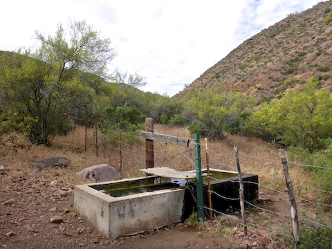
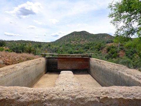
At the three mile mark, at the bottom of Deer Hill, FR 341 turns west, while Cottonwood Trail #120 and the Arizona Trail continue south, as actual foot trail, at the bottom of Cottonwood Canyon. The junction is marked by a dry trough, a large metal tank full of decent water (see the top photo), and a small corral. And foxtail. Lots and lots of foxtail. There was an incredible amount of foxtail all along the trail, but it was worst at the tank.
From the metal tank, Cottonwood Trail #120 basically winds back and forth across the bottom of Cottonwood Canyon, which at some points had slight pooling, with trickle, and others was bone dry. (On the surface: Cottonwood Creek must have subsurface flow.) The vegetation varies from desert flora to well-shaded canopy with leafy green groundcover. It reminded me a lot of Arnett Creek & Telegraph Canyon, near Superior. At one point, the creek was just a bit too wide for me to jump across, so I built a ‘bridge’ with a dozen rocks.
At the 4.5 mile mark, just past the second slant-bolted metal tube gate, is a ~30 acre burn area, about a ½ mile long, on the lower west slope of Cottonwood Canyon. The trail passes right through it, but I still managed to wander off trail, smearing my pack with soot. 🙄
The burn area had the greatest quantity & density of flowers on Cottonwood Trail #120, which was already riddled with species. I counted at least 30 different flowers, including Flat Top Buckwheat, Mexican Gold Poppy, Desert Globemallow, Machaeranthera, Buckhorn Cholla, Sacred Datura, Desert Marigold, Strawberry Hedgehog, what I believe were Bluestem Pricklepoppy, Owl Clover, Lupine, Desert Chicory, Dudleya, Ocotillo, Blackfoot Daisy, Mexican Vervain, Desert Beardtongue and many more! The New Mexico Thistle — some 6 ft. tall — with MASSIVE blooms.
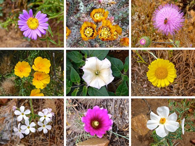
Top Row: Machaeranthera, Buckhorn Cholla, New Mexico Thistle.
Middle Row: Mexican Gold Poppy, Sacred Datura, Desert Marigold.
Bottom Row: ???, Strawberry Hedgehog, Bluestem Pricklepoppy.
Cottonwood Spring is supposedly 5.25 miles up canyon from Frazier Trailhead. I could not find it, nor any evidence — water trickling across the Cottonwood Trail #120 or moisture in the canyon bottom. Just past the spring’s ostensible location, the the Arizona Trail Association is rerouting the trail off the rocks at the bottom of the canyon, up slope 20 ft. or so. Fresh tred has been scraped, flourescent flags planted, and shrubbery trimmed. A couple of hundred yards past the trail work, there is a 5 ft. cairn apropos of nothing. 🤔
At the 6.1 mile mark is the sixth trough I spotted, the fourth bone dry one. 300 yds. past that, not far from Pinyon Mountain, is the end of Cottonwood Trail #120 at FR 83. There is nothing at the end of the trail: No sitting rocks, no shade. Enh. Kind of anticlimactic considering how enjoyable the hike was to that point.
So, I backtracked to the nearest dry trough, sat back against it, and took a break while the sun beat down my shoulders. At least the temperature was a very moderate 77℉. After my break, I booked it back to the Frazier Trailhead, where I downed my sodium & potassium restoring V-8, before my wife & drove back to Tonto Basin for cold beers & delicious pizza at Big Daddy’s. 🍕🤗
Directions: From Phoenix, exit Loop 101 at Shea. Go east on Shea to the Beeline Highway (AZ-87). Go north on the Beeline Highway for 46 miles to AZ-188. Go east on AZ-188 for 33.7 miles. Just past the Roosevelt Lake Marina, on the south side of AZ-188, there is a small substation. Turn onto that dirt road. The Frazier Trailhead is behind the substation.
GPS File: Cottonwood_Trail_120
Distance: 13.59 mi.
AEG: 2,199 ft.
Time: 5h 51m
Hiking Video
Hiking Cottonwood Trail #120, Superstition Mountains from Preston McMurry on Vimeo.