

Back out to Spur Cross to have another go at the Elephant Mountain loop, this time with a loaded route in the GPS. I figured if I started at 0700, I could be done by 1000, 1030 at the latest, then get back in plenty of time to shower before watching the US Grand Prix at 1130.
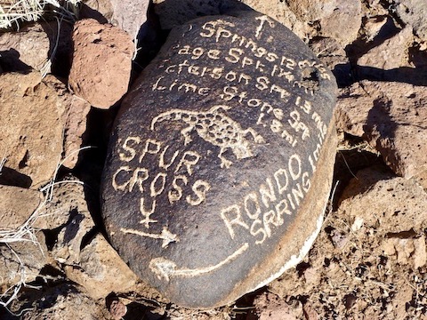
It was really chilly when I started, so I wore my wife’s fleece hoodie the first two miles. I only needed it until the sun started coming over the hills, killing the breeze. Like Pam and I wrote last week, the final half mile from Tortuga to Limestone Trail #252 is indeed primitive. Oddly enough, just having the route in my GPS made the trail more obvious on the ground, without necessarily referring to the GPS. The intersection sign at Limestone Trail #252 is carved in a rock, petroglyph style. It’s two miles from the port-a-potties.
After turning south on Limestone Trail #252, the trail becomes more obvious, though there are places where it turns that slow walking helps pick out cairns. Once I began ascending from the wash, the terrain changed from desert to grassland. There is a split in the trail at a second petroglyph trail sign. I looked east, and a few yards away was a small metal tank. Across the wash I could see a trail post. I descended into the wash, and after I climbed out, there was the intersection with the Elephant Mountain Trail. (Or, as I call it, the short cut.) It was 0845 by the time I got there, and I was already concerned I would miss the race if I kept going, but there was no way I was bailing a second time.
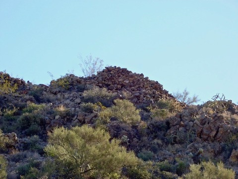
The next half mile to the Elephant Mountain / Hill 3342 saddle was a series of Ballantine Trail-like step-ups. Taking my route, it was 3.61 miles and 1264 AEG to the saddle. I took a break, and enjoyed the view. Weaver’s Needle, some 47 miles away, was obvious. As were the fortifications atop Hill 3342. (There is also a faint foot trail to Elephant Mountain Summit.) I thought about taking 30 minutes to climb up 3342, to do some exploring, but with time getting critical decided to save it for another day.
The trail from the saddle south to Spur Cross Trail is also listed as primitive, but not even close. Really, the only “primitive” parts of the whole day were the 1.5 miles north of the short cut. Once I started descending I tried to make quick time, but still only got to the big lot at 1135, or just after the green flag. Oh well, I’ll watch on the replay at night.
Started watching replay, fell asleep exhausted at 2200. 😴
Directions: From Loop 101 / Pima Freeway, head north on Cave Creek Rd. for 12.2 miles. Just as the road curves east into ‘downtown’ Cave Creek, turn left onto Spur Cross Rd. Take the next right, then a quick left. The trailhead is four miles ahead. The final mile is semi-paved but car drivable. There is no fee to park, but there is a $3 envelope fee to hike / bike / horse ride into the conservation area.
Distance: 8.01 mi.
AEG: 1,541 ft.
Time: 3h 11m