

Bowl of Fire is not Valley of Fire, which is a Nevada state park. Bowl of Fire is part of Lake Mead National Recreation Area, which belongs to the National Park Service. The feds. Uncle Sugar.
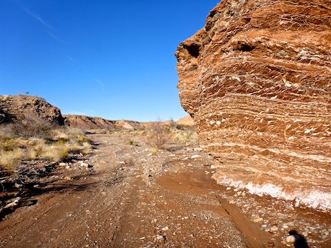
Other than the legal niceties, Bowl of Fire and Valley of Fire have similarly stunning orange, red & pink Aztec sandstone formations. But Bowl of Fire is 30 minutes closer to Las Vegas and, unlike crowded Valley of Fire, chances are good you will not see another person all day. 👍
You can loop hike Bowl of Fire in myriad different ways, or do a shuttle hike as I did, but for those without navigation skills, or who just want a short, scenic hike, you have options:
- Bowl of Fire Trail is a 2.6 mile, 250 AEG (accumulated elevation gain), out & back stroll from an unmarked pullout just north of milepost 18 on Northshore Rd. / NV-167.
- Northshore Summit Trail is a 0.6 mile, 200 AEG out & back to the small prominence opposite Razorback Ridge. It is a proper trailhead with marked parking spaces and a pit toilet, between milepost 20 and 21.
- Do both!
I always need miles, I like exploring, and my wife is a willing shuttle driver, so I opted for the Bowl of Fire to Northshore Summit shuttle hike.
There are numerous pullouts along Northshore Rd. / NV-167, so I can’t say with any certainty which one is the trailhead for the Bowl of Fire Trail. There is no sign. All I can say is that the pullout is just north of milepost 18, on the west side of the road, and is one of the few pullouts with a garbage can. (One of the rectangular, tilted, sandy-colored ones, with a latched top.) You won’t be able to spot the pullout because of the cairn: It’s too small. 👀
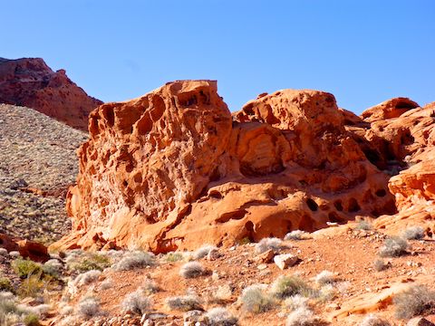
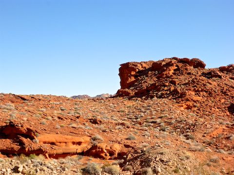
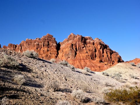
After finding the correct pullout, it still took me a couple of minutes to figure out where the Bowl of Fire Trail was, and I only figured that out after my eagle-eyed wife spotted the cairn. The trail does not get much foot traffic, so it is faint in spots: More of a disturbance in the desert surface than an actual worn trail. If you look west, past the cairn, towards the red rocks, that is Bowl of Fire. Between the pullout and the red rocks is a small hill. The trail heads toward the hill’s northern tip.
Crossing Callville Wash, I lost the Bowl of Fire Trail for a few yards, before noticing some orange ribbons marking where I should have gone. Still, it only took me 30 minutes to hike the 1.3 miles to the first red rocks.
The temperature was perfect hiking weather, with temps in the low-50s. I did not need a jacket, and only drank about 1.4 liters of liquids in 4½ hours.
The first major formation, where the Bowl of Fire Trail ends, has a couple of easy, slightly scrambly, routes up its backside. I spent a couple of minutes on top, admiring the views, before dropping back down. Casual hikers will want to turn around at this point. I headed off trail. 🗺
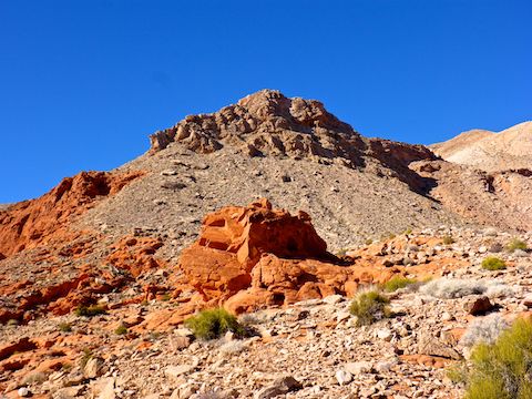
I can’t really describe the route I took from Bowl of Fire to Northshore Summit, other than to say I tried to find as many beautiful red rocks as I could, while also taking the path of least resistance. I had used satellite view to plan my route, and for the next 1.8 miles, it worked well, and I followed it pretty close. Check out the GPS file below.
The most interesting rocks I saw in Bowl of Fire were on the ground: There was one boulder that was covered with dozens of small desert varnished hoodoos. On the saddle where I had lunch, there were a number of delicate hand-sized rocks each covered with numerous overlapping concave surfaces. (See 3:11 in the hike video below.)
Mile after mile of the area was covered with ½” Aztec sandstone marbles. I thought two of the marbles had copper mineralization, but upon picking them up, I discovered it was lichen. The marbles were not at all slippery, as I found them on flatter, hard-packed sand surfaces, rather than boulders.
Anything that was not Aztec sandstone — e.g. granite — is way rougher than it looks, with razor-sharp edges. Take care picking up any rocks: By the end of the day, my hands were covered with scrapes. 🚑
The vegetation in Bowl of Fire was scattered and not at all stabby. Very few cacti. I only saw one plant with flowers, which were too tiny for my pocket camera to get focused photos of.
After a quick snack break, I left the Bowl of Fire after 3.3 miles, commencing 1.9 miles of steep wash crossings as I attempted to find a route to Callville Wash that was both easy and scenic travel. It was a crapshoot if any given gully, as twisty as they all were, reconneted me to Callville Wash or not. Thus all the wash crossings, which really wore me out. 😅
Many of the wash crossings, particularly after leaving Bowl of Fire, showed signs of recent flash flooding, such as mud or flow patterns, but no stacked brush.
The ½ mile I was in Callville Wash was SUV-able, with very few rocks and relatively firm sand. Indeed, there were a number of 4-wheel tracks. It was moist in spots, and I even saw a few small puddles.
Where I saw some fenceless metal poles, I left Callville Wash, turning up a very narrow side wash. I had a suspicion it would turn into the west end of Northshore Summit Trail, which it did a ½ mile later. The transition is marked by a cairn.
It is 300 ft. up to the Northshore Summit ridge, but that comes in only 0.4 miles, so it is a good blow. Once on the ridge, Northshore Summit Trail meanders another ⅓ of a mile to a split: Left is down to the trailhead; right to the summit itself. I went right.
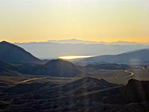
Despite being only a 200 ft. prominence, Northshore Summit has some decent views. Through the distant Las Vegas haze, I could see the rapidly descending sun glaring off Lake Mead. Rather than take the “steep” direct route down to the trailhead, I doubled back to the previous split, then headed down. The only two people I saw all day, were 200 yds. ahead of me. 👍
It took my wife & I 90 minutes to drive back on Lake Mead Blvd., past Nellis Air Force Base, to North Las Vegas, where I did my recovery at the Bacon Bar. Pretty much everything at the Bacon Bar has bacon — even the Bloody Marys! I had bacon-wrapped jalapeno poppers and the Ultimate Bacon Cheeseburger, washed down with Oskar Blues Brewery’s Hotbox Coffee Porter and Garage Brewing Company’s Marshmallow Milk Stout. All delicious. Oh, and I got an order of Man Candy (maple-glazed bacon) to go. The next day, I had pig coming out of my pores! 🐷
Directions: From Las Vegas, head east on Lake Mead Blvd. / NV-147. Two miles before you reach Northshore Rd. / NV-167, there is a National Park Service gate. The length and cost of a pass varies, but a car is $25 for a seven day pass (the shortest available). At Northshore Rd. / NV-167, turn left. The Bowl of Fire pullout is on the west side of the road just past milepost 18. Northshore Summit Trailhead is on the west side of the road between milepost 20 and 21.
GPS File: Bowl_of_Fire_Northshore_Summit
Distance: 7.72 mi.
AEG: 1,433 ft.
Time: 3h 33m
Hike Video
Hiking Bowl of Fire to Northshore Summit from Preston McMurry on Vimeo.