

Usually, my wife & I have our annual romantic Las Vegas visit earlier in December, but this year we could not swing it until Christmas week.
We drove up Saturday, staying — as usual — at Wynn’s Encore Tower Suites. It’s pricey, but the service is awesome, the rooms great, and the cost at Las Vegas’s cheapest time of year. Just a week later, room prices double, or even triple! 💸
On Sunday, my wife & I hit Cannabition, a cannabis museum in downtown Las Vegas. It was cheesy, but fun, and featured the world’s largest bong: 24 ft. tall, with a four ounce bowl. Smoke that! From Cannabition, we headed over to Linq’s High Roller — pun not intended — the world’s tallest ferris wheel. I recommend the “happy hour” car, which for only an extra $15 is all you can drink. I slammed four drinks, which is not bad for 30 minutes. We ended the day at the MGM Grand, catching Drew Thomas at Brad Garrett’s Comedy Club. 🤣
Monday was Christmas Eve, and before celebrating our 12th Proposal Anniversary, my wife & I drove out to Valley of Fire State Park so I could hike the Prospect Trail.
The Prospect Trail is short, only 4.6 miles, with not much elevation change, so I planned to also do the White Domes Loop at Prospect’s north end, then hike Fire Wave at the end. Besides the exercise, I figured that would give me enough material for a decent length hike video. I should have known better: Valley of Fire State Park absolutely loaded with amazing rock formations. 😳
The south end of Prospect Trail is on the north side of Valley of Fire Highway, just east of Atlatl Rock. The trailhead is just a pullout, with a few signs, and no pit toilet, picnic table, or any of the other niceties. I kind of like it that way: It keeps the horde at bay.
It had been a chilly 41℉ at breakfast time in Las Vegas, but by the time I started hiking at 9:30 a.m., it had warmed up enough that I could remove my hoodie, and use exercise-generated body heat to keep me warm.
The first half of the Prospect Trail, to the first of the dryfalls, alternates between jeep trail and foot trail. It’s the same path, it just gets wider and narrower at different points. Probably due to erosion. Whether foot trail or jeep trail, the surface is rarely an issue. If it wasn’t chained off, you could probably drive it in your car.
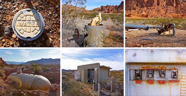
Four tenths of a mile north of Valley of Fire Highway, the jeep trail turns east. Though Prospect Trail continues north, I first headed east to check out some whazzits. (A ‘whazzit’ is why I call an interesting object I see, but cannot identify, on satellite view.) The whazzits ended up being a large fiberglass water tank and a inoperative pump house. There were some other bits & pieces laying about, including what looked like a collapsed antenna. I wonder what the pump house’s purpose was? Besides simply pumping water. 😏
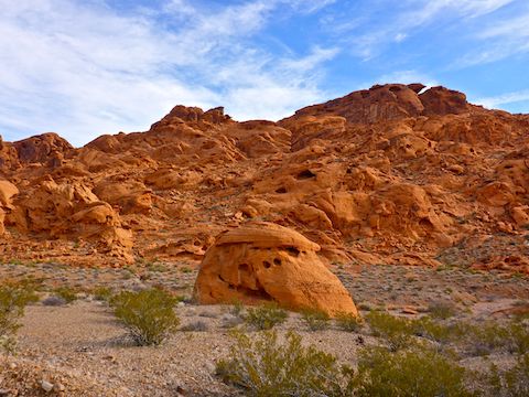
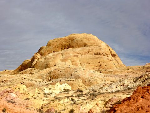
From the pump house access road, Prospect Trail begins a gradual climb of 200 ft. in ¾ of a mile. As you get closer to the saddle, the main orange cliff / mountain gets closer to the trail. Wild orange outcroppings are closer yet. The hills just west of the trail look like old ocean sediment rather than the cliff / mountain’s orange sandstone. I guess Valley of Fire’s orange formations were used for the original, and much better, “Total Recall” starring Arnold Schwarzenegger, but they reminded me of Bedrock, home of the Flintstones.
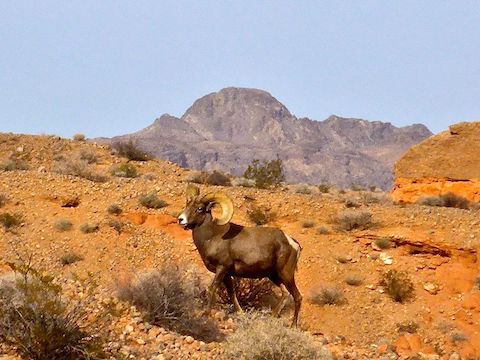
As I descended from the saddle, I was passed by three other hikers, because I was taking so many photos. (Close to 200 on the day!) I caught up to them around the two mile mark. As I began to pass them, they brought my attention to group of four male desert bighorn sheep: Three mature rams, and one young adult, with partially curved horns.
One of the things I’ve noticed about the terrain in Nevada is that it is very stark and barren relative to Arizona. Still very beautiful though, especially in Valley of Fire. Nevada has much less brush or cacti: No cottonwood, palo verde, saguaro, cholla (of any variety), etc. The only grab & stabs I saw were some desiccated prickly pear and a few fishhook barrel cactus. Of course, I did not see the only two catclaw on Prospect Trail. 😖
The first dryfall is two miles north on Prospect Trail. It is so small — maybe three feet — that it hardly counts. Yet, it is noted on the park maps. 🙄
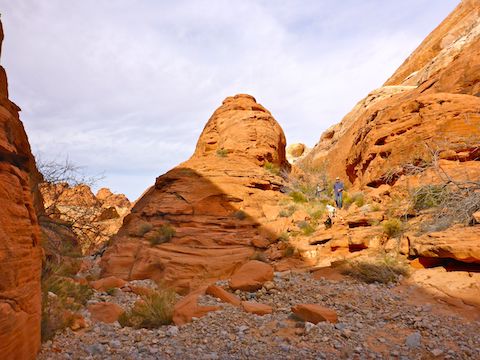
Over the next 1.5 miles, the Prospect Trail alternates the occasional dryfall with wash walking. There are only two real dryfalls: The first, just after entering the wash, at 10-12 ft., is smaller & trickier than the second. It is bypassed to the right, via some rather slippery slick rock. The second, about 18-20 ft., could be downclimbed by an experienced hiker, but I opted to take the official bypass to the right. I encountered several more hikers, and dogs, by the larger dryfall.
The wash walking varies from usually gravelly, to sandy or rocky. There are a number of side washes, but you should rarely be out of sight of the next white guide pole.
Past the larger dryfall, the orange formations generally give way to white and mustard rock, often laced with pink and purple bands.
Near the end of Prospect Trail, 4.4 miles into the hike, I encountered the only confusing part of the route. To my right was a small slot canyon. To my left, a faint trail headed out of the wash. I saw no white guide poles, so I started to follow the faint trail. I did not go far, before doubling back, into the small slot canyon (which is the correct route). The large, rounded, white formations to either side of this area are the White Domes.
As you head east into the small slot canyon, you will probably hear voices. The White Dome Loop is just 100 yds. ahead.
There were scads of people on the White Dome Loop, so I finished the last ¾ of a mile as quick as possible. The White Dome Trailhead was full to overflowing — as was every other parking area the entire 6.7 mile length of Mouse’s Tank Rd., from the White Dome Trailhead to the Visitor Center, back on Valley of Fire Highway.
Directions: From Las Vegas, head north on I-15. At the Moapa Paiute Travel Plaza, take exit 75 southeast onto Valley of Fire Highway. The front gate is in 14.5 miles. The day use entry fee is currently $10. The Prospect Trail trailhead is on the left, two miles past the entrance. If someone is picking you up at the White Dome trailhead, continue another 1.5 miles, then turn left on Mouse’s Tank Rd. Drive 6.7 miles all the way to the White Dome trailhead at the end of Mouse’s Tank Rd.
GPS File: Prospect_Trail_Valley_of_Fire
Distance: 6.56 mi.
AEG: 584 ft.
Time: 3h 00m
Hike Video
Bighorn Sheep Video
Desert Bighorn Sheep, Valley of Fire from Preston McMurry on Vimeo.
Big horn sheep, awesome!
I’ve seen them every time I’ve been there!
Great videos! I like the music also.
Appreciate it! 😁