
. Casa Grande 1 and the antenna farm are visible on the left.")
Tuesday, I was scheduled for my monthly Lunch With Mom in Casa Grande. Wednesday, was supposed to be watching Celtic F.C. at The Desmond in downtown Phoenix. Thursday, I intended to hike Webber Creek, at the base of the Mogollon Rim. But I didn’t think it would be fair to drag my loving & supportive wife hither & yon three straight days, so I asked if she minded leaving early to get a hike in early before Lunch With Mom?
Thankfully, she said “yes”. (The first time she said “yes”, I had to wait an hour for her answer.) 💍
With little time to prepare Monday night, I threw something together that looked like it would have some oomph!, and be doable in roughly two hours. What I came up with was hiking the Bolt Trail up to Casa Grande 2, traversing Casa Grande Ridgeline for a mile, doubling back to the antenna farm, then taking the access road back to the Hanna Rd. Trailhead.
When we arrived at the Hanna Rd. Trailhead at 7:00, the west side of the Casa Grande Mountains was still deep in shade. Plus, it was chilly, with a stiff breeze. I spent my time on Twitter, while watching the mountain’s shadow gradually creep towards us. As soon as the sun hit my SUV, I started getting geared up.
Such as it was. Today, I travelled light: No poles, and a Camelbak in place of my full pack. Expecting good cellphone reception so close to I-8 and I-10, I didn’t see the need for any emergency gear. I want to travel light more often, since carrying a pack takes so much extra energy. 📲
It was a good thing I brought my cellphone, as I forgot the batteries for my pocket camera. In addition, I had my GoPro in a STUNTMAN chest mount, as I’ve also been wanting to tape more than just my bike rides. Carrying a selfie stick is not only dangerous, it makes one look like a self-absorbed tool.
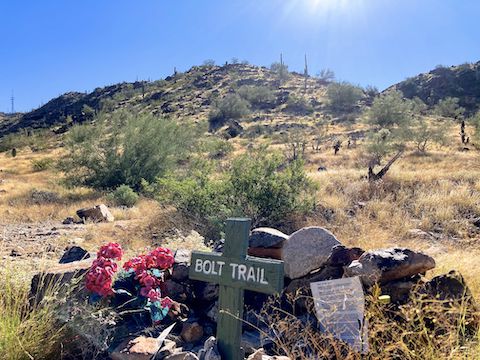
I started hiking east on Hanna St. about 7:40 a.m. It was quite rocky. Okay to walk, but would not want to drive it past the trailhead. Hanna St. crossed two small washes, and I was back in shadow. At ⅓ mile, Bolt Trail splits right at the first memorial. The trail is named after Joel Branham Bolt, who pioneered the well laid out route his namesake trail follows.
Well routed, yet steep as all get out. Between Hanna St. and the top of the climb at Casa Grande 2, Bolt Trail ascends 724 ft. in under ⅔ mile. The climb is in three distinct sections: A very steep 328 ft. in .24 miles (26% grade), followed by what seems like a relatively flat 171 ft. in .22 miles (“only” 15%), then the kicker to finish of 225 ft. in .14 miles (30%). Overall, the equivalent of 1200 ft. in one mile. My weekly trip up North Mountain paid dividends: I did the Bolt Trail climb non-stop, in only 23 minutes. 💪
At the top of the Bolt Trail climb, the trail splits: Left, down to the antenna farm, somewhat to the right, along the Casa Grande 2 contour, or more rightish 20 ft. up to the summit of Casa Grande 2 (aka Hill 2332). Up I went. Why? In Mallory’s famous words, because it was there.
The best route down is via cement antenna farm road, due to vastly better grip than Bolt Trail. (It’s always easier to climb a slippery, or broken, surface than to descend it.) If you called it a day from the top of Casa Grande 2, the round trip would be 2 miles, 850 AEG (accumulated elevation gain) — a solid pre-work workout. Somehow, the antenna farm road seemed even steeper than Bolt Trail.
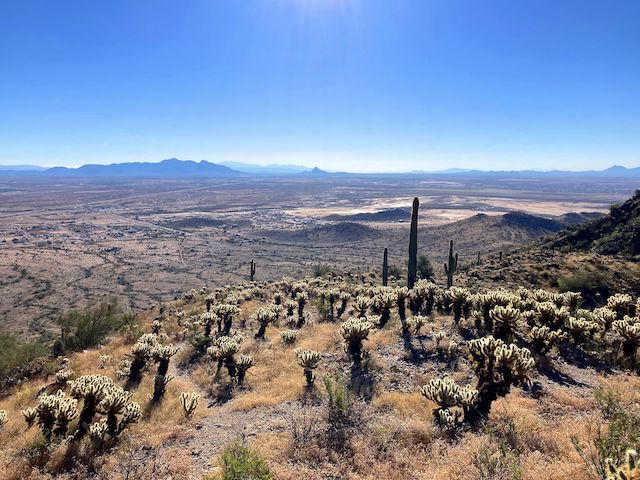
From the top of Casa Grande 2, I headed south along Casa Grande Ridgeline Trail. The well-defined trail crosses several small hilltops and saddles. In ½ mile, Casa Grande Ridgeline Trail climbs 100 ft. in 200 yds. to the top of Casa Grande 1, aka Hill 2350, aka The Flagpole. (So named because it is crowned by Old Glory.) I read somewhere the current flag served in Afghanistan. 🇺🇸
Most people turn around after visiting The Flagpole. A round trip to Casa Grande 1 is 3⅓ miles, 1,100 ft. AEG. However, it is only another ⅓ mile to Casa Grande Ridgeline’s final hilltop.
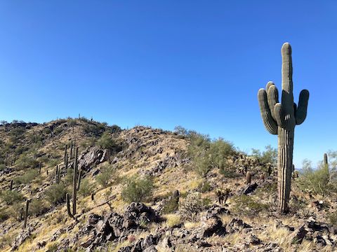
South of Casa Grande 1, the trail gets less distinct: A bit rockier, grass encroaching, and dotted with fallen cholla buds waiting to jump on your calves. Still, if you’ve spent any amount of time hiking in the Sonoran Desert, the final ⅓ mile is bueno.
Casa Grande Ridgeline Trail actually continues past the final hilltop: I can see on satellite view it continues at least ¾ mile past Hill 2251, and have read it can be followed to south base of the Casa Grande Mounains at Spine Trail Loop or the Corona Satellite Calibration Target on Henness Rd. 🛰
Having arrived on the final Casa Grande Ridgeline Trail hilltop, I turned off my GoPro and started taking photos. Great views in all directions! But I did not dally, and light on my feet, moved quickly back along Casa Grande Ridgeline Trail to the antenna farm, then down to the trailhead.
No sodium and potassium restoring V-8 was waiting for me, so when my wife & I arrived at the Casa Grande Cracker Barrel, I started my Mom Lunch with a Bloody Mary. 😆
Hanna Rd. Trailhead Directions: From Phoenix or Tucson, take exit 199 onto westbound I-8. In four miles, at the first interchange, take exit 174 south onto Trekell Rd. The speed limit is 25 mph, and PCSO deputies were seen in the area. In ½ mile, turn left onto Hanna St. As you head east, you will see the road continue up to the antenna farm, but park in ¾ mile at the Hanna Road Trailhead. Beware the many bottles, broken and yet to be broken.
GPS File: Bolt_Trail_Casa_Grande_Ridgeline_Antenna_Loop
Distance: 4.01 mi.
AEG: 1364 ft.
Time: 1h 45m
Hike Video
Hiking Bolt Trail, Casa Grande Mountains from Preston McMurry on Vimeo.