

The Black Canyon Trail (BCT) is a National Recreation Trail that stretches 93 miles, from Carefree Highway, in north Phoenix, to the John 3:16-17 spring box, near AZ-169 in Yavapai County. Years ago, there were plans to extend the BCT further north, into the Verde Valley, maybe even to Williams. But I’ve heard nothing since. If it happens, I hope it is before I get too old. As of today, I consider my BCT hike complete.
The Black Canyon Trail is for horses, mountain bikers, hikers and trail runners. Motorized vehicles are not allowed, but the BCT is crossed by many forest roads and uncountable OHV trails, some of which occasionally wander off track. 😏
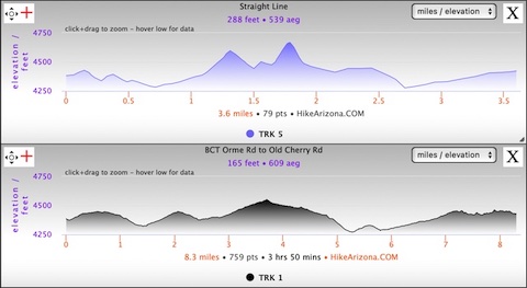
Heading south on the Black Canyon Trail is generally downhill, while north is generally uphill. The segment from Orme Rd. to Old Cherry Rd. is rolling, with four small climbs, none more than 170 ft. at 3.2% grade. Despite being single track, the BCT is smooth, and only rarely rocky.
Going uphill on a mountain bike is much more difficult than hiking. Because the Black Canyon Trail is so popular with MTBs, it has been optimized for their use with scads of switchbacks. Not just on the “climbs”, but weaving around the tops of draws & washes, rather than directly crossing them.
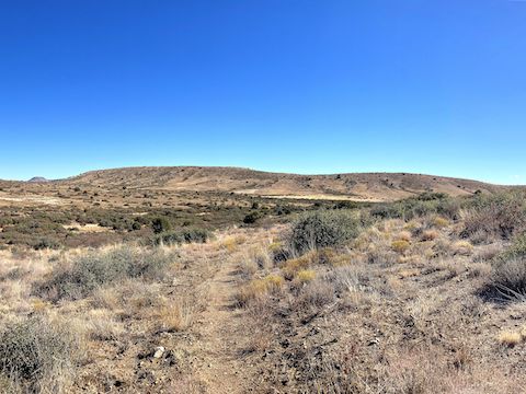
So, as I stood at the trailhead on Orme Rd., it was 3.6 crow flies miles to the John 3:16-17 spring box on Old Cherry Rd., but 8.3 Black Canyon Trail miles. Most of those extra miles are due to the BCT working its way around the unnamed two-mile long ridge which is the dominant terrain feature of this hike. 🚵🏻♂️
Though it was close to freezing a few hours earlier, when I started hiking at 10 a.m. it was a perfect 60℉. After ¼ mile, and several switchbacks, the Black Canyon Trail crosses the first of four MTB rollover metal gates. (This segment also has two wire loop wood gates.)
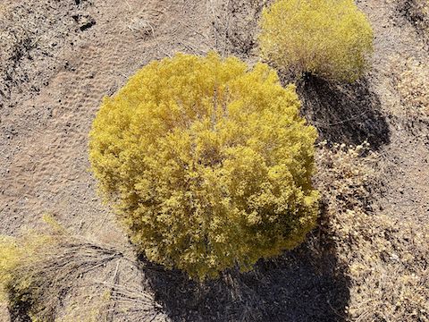
Other than crossing washes, the vegetation on this Black Canyon Trail segment is sparse. On several occasions, I took advantage of the junipers’ good sitting shade. Two clusters of juniper were particularly dense with berries (at the ¾ and 6⅔ mile marks).
After 1⅓ miles, the Black Canyon Trail crosses Osborne Spring Wash. Like every other wash between Orme Rd. and Old Cherry Rd., Osborne Spring Wash was dry. It did have plenty of OHV tracks in its mushy sand though. 🛻
The Black Canyon Trail then passes east of Bill West Tank (dry), crosses the first wire loop wood gate on an unnumbered jeep trail at the two-mile mark, traverses several anonymous washes, and finally begins approaching the northern tip of the two-mile long ridge after 3⅔ miles. The second MTB rollover metal gate marks the location, overlooking SanDam Ranch. It is also this BCT segment’s high point.
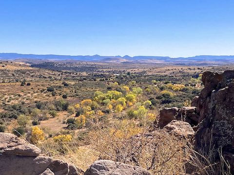
After some more switchbacks, the Black Canyon Trail crosses a plain that is at first grassy, then scattered with baseball size rocks. Maybe volcanic debris? It was the only area like that between Orme Rd. and Old Cherry Rd. Just past the rocky baseballs, at the 4¾ mile mark, is the outcropping with a nice view of Ash Creek.
Unlike last year on the General Crook Trail, Ash Creek was dry. Exiting Ash Creek, the Black Canyon Trail parallels a jeep trail, which is just a few yards away. Why? At the top of the Ash Creek basin, there is a double gate: a MTB rollover metal gate for Black Canyon Trail and an adjacent wire loop wood gate for the jeep trail. Again … Why? 🤔
Old Cherry Rd. is on the other side of the double gates. If you turn left (north), it is only 1½ miles up the road to the John 3:16-17 spring box. If you stay on the Black Canyon Trail, you have 2¾ miles to go. If I was riding a MTB, either direction, I would take the shortcut, to avoid the rocky and sandy final mile.
After a few final switchbacks, the Black Canyon Trail crosses Hackberry Wash at the 6-mile mark. It was also dry. The BCT then parallels Hackberry Wash for a fairly straight mile to the fourth MTB rollover metal gate. It was the most desolate section of the day.
There is a t-intersection 300 yds. past the gate. The Black Canyon Trail turns left, along Trail #64, the Prescott National Forest segment of the General Crook Trail. A ¼ mile after the turn is the final wood gate. The loop was easy to pop, but difficult to replace. The last mile of the BCT alternates small, rocky, climbs with mushy, sandy, washes, and is often rutted. I wouldn’t want to bike it.
I arrived at the John 3:16-17 spring box on Old Cherry Rd. after three hours of hiking, completing the Black Canyon Trail. I finished the C&O Canal last week, and plan to finish the Maricopa Trail in April.
Orme Rd. Directions: From I-17, take exit 268 west, onto smooth dirt Orme Rd. In ⅓ mile, the road splits. Go right. Between MP 7 and MP 8, as you cross a small wash, park in the FR 68B camping area.
Old Cherry Rd. Directions: From FR 68B, continue north on Orme Rd. In 5.4 miles, turn right on paved AZ-169. In 4.5 miles, at the green Cherry Rd. signs, turn right on FR 372. In 0.4 miles, park in the pullout on the right.
GPS File: BCT_Orme_Rd_to_Old_Cherry_Rd
Distance: 8.82 mi.
AEG: 627 ft.
Time: 3h 03m
Rumble Video
Vimeo Video
Black Canyon Trail: Orme Rd. to Old Cherry Rd. from Preston McMurry on Vimeo.