

Hiking from the corral near Government Spring to Antelope Creek Rd., a mile southwest of the ghost town of Cordes, is the tenth segment, south-to-north, of the Black Canyon Trail.
The BCT is a National Recreation Trail, that starts at Carefree Highway, in far north Phoenix. At one time, the Black Canyon Trail was 80 miles to Russian Well, in Brushy Wash, in the middle of nowhere. The BCT has since been extended another 16 miles north to AZ-169 near the Buckbed Wash landfill in Yavapai County. 🗺
I hear there are plans to extend the Black Canyon Trail even further north, across Arizona’s Black Hills into the Verde Valley, and maybe even to Williams in the pines of northern Arizona.
Why stop there? Extend the Black Canyon Trail all the way to the Arizona Trail at the Grand Canyon!
There are several ways to hike the tenth segment of the Black Canyon Trail:
- The Whole Out & Back: From either end, 10.0 miles, with 1,000 ft. accumulated elevation gain (AEG). If you start from Antelope Creek Rd., your return trip will be uphill 950 ft. If you start from the corral, your return trip will be downhill and there is shade for your car in warmer months. That’s the option I chose. ✅
- Corral North to Saddle: An easy out & back hike anyone can do at 3.0 miles, 150 AEG. The saddle has nice views west towards Government Spring and the Bradshaw Mountains.
- Bumble Bee to Antelope Creek Rd.: A 11.1 mile key exchange / shuttle hike. Northbound 1,700 AEG; southbound 300 AEG. That was my goal in March, 2018, but the complete lack of flowers caused me to bail at Government Spring.
- Government Spring to Mayer: A 12.5 mile key exchange / shuttle hike. Northbound 1,700 AEG; southbound 700 AEG. I probably would have done this, but my wife stayed home baking Christmas cookies.
The Government Spring TH, at the intersection of Crown King Rd. and Antelope Creek Rd., is formally known as the Hidden Treasure Mine Trailhead. (Even though there is nothing left of the mine, which was a ¼ mile west.) The corral, at least, is right on Government Spring Wash. The cattle tank was very low, though the spring box did have plenty of water.
The Black Canyon Trail heads northeast, out the backside of the corral, crossing Government Spring Wash, and several tributaries before reaching Gas Pipeline Rd. in ¾ of a mile. (This is the same Gas Pipeline Rd. crossed by the BCT at numerous other points.) From Gas Pipeline Rd., the BCT climbs 150 ft. in ¾ of a mile to the saddle I mentioned above.
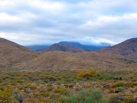
The saddle is one of three good views on the Government Spring to Cordes segment of the Black Canyon Trail. The switchbacks between the saddle and the steel gate, have really nice views south towards Sunset Point. (The antennas at the rest stop are visible to the naked eye.) The final — and BY FAR the best — view is the panoramic vista west towards the Bradshaw Mountains from the Antelope Creek Rd. trailhead. Stunning. Would be an awesome car camping sunset spot. 🌅
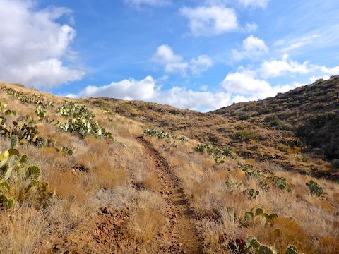
Regarding the switchbacks, there’s got to be dozens of them in the 1½ miles between the saddle and the cairn. No lie. The Black Canyon Trail could have just followed the spur up from the saddle, halving the distance, but is instead highly optimized for mountain bikes. It gets old after awhile, especially on the return trip.
Just under 3½ miles north of of Government Spring, there is a gate across the Black Canyon Trail. It’s one of the square steel tube gates, with easy to manipulate latches, that have become common along the BCT the past few years. Just past the gate, I looked up canyon and thought I saw a foundation, which I believed to be part of a nearby mine. ⚒️
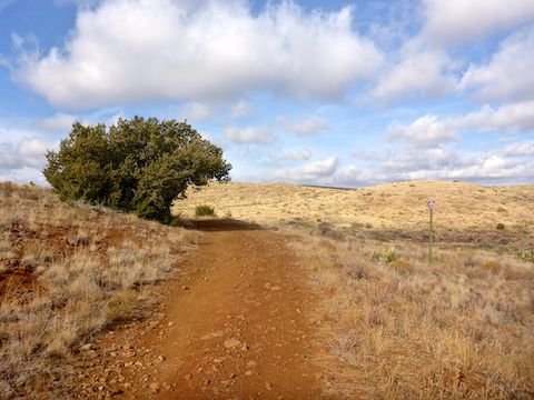
A half mile past the gate, the Black Canyon Trail turns left onto a jeep trail. The only shade between Government Spring Wash and Antelope Creek Rd. is a large juniper midway along the jeep trail.
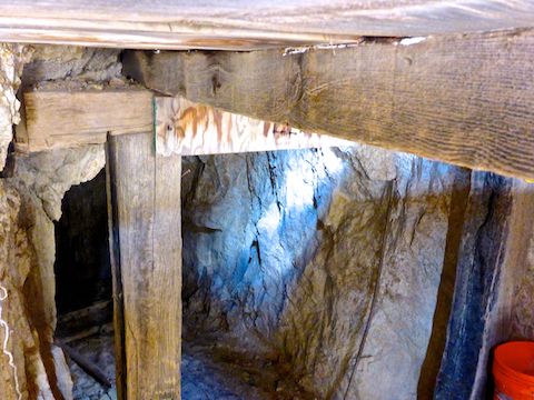
But first I turned south towards the mine. No artifacts laying about, unless you count a shot up metal tank. The adit had a locked door and warning signs, so I settled for aiming my camera over a gap in the transom. After the mine, I hey diddle diddled up to Antelope Creek Rd. Turns out Cordes is a mile east. 😏
The Government Spring to Cordes segment of the Black Canyon Trail is mostly smooth as glass. Government Spring Wash is sandy, but not too bad, and there’s a few slighty rocky switchbacks. Basically, pristine. The only obvious exception is the ¾ of a mile between the jeep trail and Antelope Creek Rd. It is obviously used much less often than the jeep trail. Personally I followed the trail to the road, walked west on the road, then took the jeep trail back to where they split.
I did a little off trail on the way back to the gate. Turns out the “foundation” was a very pronounced vein of white rock. Looking at satellite view, there are many other obvious veins in that area. There is Verizon reception south of the gate, probably because of the antennas at Sunset Point. After a short lunch break, I hauled butt back to Government Spring.
Government Spring TH Directions: From Phoenix, head north on I-17 to Exit 248, to Crown King Rd. Pass under both segments of I-17, taking care not to get back on I-17 southbound or, worse, against the flow of southbound traffic. (Easy to do if you are not paying attention.) The road is very twisty and soon turns to dirt. Two miles from I-17, merge north on Crown King Rd. through Bumble Bee. The corral is 4½ miles north of town, on the right.
Antelope Creek Rd. TH Directions: From Phoenix, head north on I-17 to Exit 259. Head west on dirt Bloody Basin Rd. for three miles to the ghost town of Cordes. At the t-intersection, turn left on Antelope Creek Rd. In 1¼ miles, just after crossing the BCT, as the road begins descending into Black Canyon, turn left into the trailhead.
GPS File: BCT_Government_Spring_to_Cordes
Distance: 11.93 mi.
AEG: 1,330 ft.
Time: 4h 15m
Hike Video
Black Canyon Trail: Government Spring to Cordes from Preston McMurry on Vimeo.