

The Goldfield Mountains are located north of Apache Junction, and south of the Salt River. The Superstition Mountains are literally across the road, on the east side of the Apache Trail / AZ-88. The Goldfields are a popular horse riding and OHV area, particularly in Bulldog Canyon, where vehicles require a special permit.
The Goldfield Mountains’ high point is Dome Mountain, but the Goldfield’s most famous peak is Pass Mountain, on the west end of the range in Usery Mountain Regional Park. ⛰
The last time I hiked in the Goldfield Mountains was when AZLumberjack and I bailed on attempt to climb Dome Mountain. I guess that was 2015. Seemed longer ago. Too long, anyway, so off I went.
My plan was to hike from the Horse Trails Trailhead, on an unnamed, unnumbered, foot trail northwest past Cottonwood Spring. After three miles, I would head north on a jeep trail through an unnamed canyon. I then planned to turn south onto another unnamed, unnumbered, foot trail to Anniversary Arch. From the arch, it is not quite three miles back to the trailhead.
I did the lasso-shaped loop clockwise, but if you head counter-clockwise, an out & back to Anniversary Arch is 5.5 miles, with 525 ft. of accumulated elevation gain (AEG). 📿
The Goldfield Mountains are riddled with jeep trails, foot trails and side canyons. It is very easy to wander off in the wrong direction. I saw no trail signs, so unless you have a REALLY good sense of direction, you should take a GPS loaded with the route attached below, which includes waypoints such as “split left” and “sharp right turn”.
After breakfast at Denny’s in Apache Junction, I arrived at the Horse Trails Trailhead about 8:00 a.m. There were a number of horse people and offroaders camping out in the large dirt lot. (No facilities though.) I managed to wander 50 yds. down Apache Trail / AZ-88 before finding my way around a fence, but the hike actually starts straight across the road.
The loop begins on a apparently decommissioned jeep trail, which is riddled with horse hoof prints. The first “split left” occurs at ⅔ of a mile, off the jeep trail onto singletrack. The second split, the base of the loop, is at one mile: Left for clockwise, right for counter-clockwise. I went left. ↖️
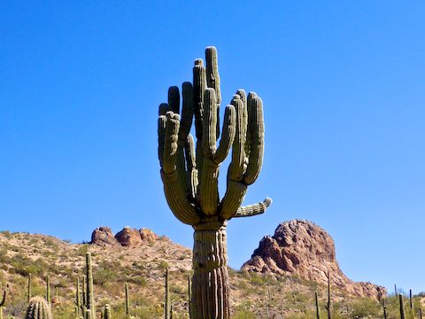
The singletrack continues another 1½ miles to Cottonwood Spring, winding between distant rock outcroppings, through grassy hills, and across dry washes. The saguaro were generally young, but I saw several that had large, apparently spineless, darker green sections that resembled alligator skin. I wonder what that is?
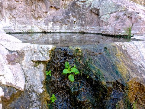
The wash between Cottonwood Spring and the spring box was muddy, though more likely from recent monsoon flooding than the slow drip of overflow from the spring’s catch basin. The spring box had some water in it, but again from rain, as the pipe was totally disconnected.
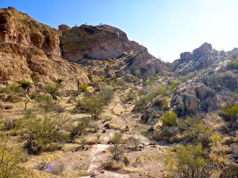
At Cottonwood Spring, I picked up a jeep trail, following that off & on down wash for the next mile. A ⅓ of a mile north of Cottonwood Spring, a foot trail splits left for a longer loop. Instead, I stayed on the jeep trail / followed the wash bottom as it instead turned northeast into a small canyon with close, lichen-covered, walls. 🏞
Just under four miles into the hike, on the south side of the wash, there (currently) is a cairn. I turned right onto the foot trail, which climbs 200 ft. in a ½ mile, the only real elevation gain on the loop, past nearby cream- and rust-colored rock formations. From the top of the climb, it is a ½ mile across a saddle to Anniversary Arch.
Both across the saddle, and from within Anniversary Arch itself, there are great views north and east, with the old standby — Four Peaks — easily visible. The reddish mountain that looks like it is about half way to Four Peaks is El Recortado, on the north side of Canyon Lake. Anniversary Arch is not large, but there is enough room for several people to comfortably sit. The arch also funneled a pleasantly cool late morning breeze.
From Anniversary Arch, the trail winds a ½ mile down to the flat below the backside, then turns south, following a wash 1¼ miles back to the base of the the loop. There’s some decent shade in the wash. Although the trail is going up, the elevation change is barely noticeable. From the base of the loop, I booked the mile back to the Horse Trails Trailhead. 🐴
I wanted to stop at the Apache Junction McDonald’s for my usual post-hike Filet-O-Fish and salt-laden large fries, but there was no walk-in, so I drove on. I needed to pee too bad. I stopped at a gas station instead — sweet relief! — and settled for an awful chimichanga.
Directions: Depending on which part of the Valley you are travelling from, either take the Red Mountain Freeway / Loop 202 or US-60. If you are driving Loop 202 east, take exit 27. Go east on University Dr. for 5.5 miles, then turn left onto Apache Trail / AZ-88 for 7.1 miles. If you are driving US-60 east, take exit 196. Go north on Idaho Rd. for 2.3 miles, then turn right onto Apache Trail / AZ-88 for 6.8 miles. The Horse Trails Trailhead is on the right, just before mile marker 203.
GPS File: Anniversary_Arch_Loop
Distance: 8.71 mi.
AEG: 888 ft.
Time: 3h 55m
Hike Video
Hiking to Anniversary Arch, Goldfield Mountains from Preston McMurry on Vimeo.