

Putting this under Alamo Lake State Park Campground, rather than Bill Williams River Gorge, as I never went in the Gorge.
Left home at 0530, dropping my wife off at Sky Harbor, before heading west on I-10. Not that they go the same place, but I find I-10 much less boring than I-8. Turned off at Salome Rd, exit 81. Speed limit all the way to Salome is 50, sometimes as low as 45, with lots of “alert strips” in the road. Probably because it is open range. But with no hills or turns — it’s as flat as a board — it was a boring 35 miles. Not much to Salome. Surprised there is a high school there. Wenden had fewer houses but more and better looking stores. (And a school crossing guard where the speed limit rapidly changes from 55 to 35 to 15: Be warned.)
Plan for the day was to bag a bunch of benchmarks. I needed something to do, thought of Alamo Lake, where I had not been before, and in topo reconing the area noticed a bucket of benchmarks along Alamo Rd and the northwest shore of the lake. First stop was to be what is one of what must be 30 “Black Butte”s in Arizona, in the middle of Butler Valley. But it looked covered with cholla, so I skipped it, proceeding to pick the low-hanging fruit along Alamo Rd. Most of the marks were within 50 feet of the road, but there as not always a safe place to pull off, so I ended doing a fair bit of walking.
Last place to park before Alamo Lake Dam is the Bill Williams Overlook. There’s a pair of marks on the hill south of the dam, and it took me quite a while to find the S-Axis, a nail-like mark, and I never did find the other. Might have been hidden under fallen boulders. (VCM C481 1981, just east of the overlook, was badly scared by fallen rock.)
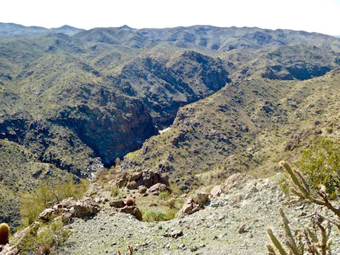
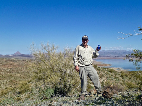
Found a couple of marks on the far side of the dam, proceeding as far as VCM B480 1981 (“BM 1351” on the topo.) By that point it was early afternoon, as all that walking back and forth along Alamo Rd had taken much longer than I anticipated. I did not think I had time to climb Hill 1655, then hike the four miles out to BM 1198 (on the dirt version of Alamo Rd north of the lake), searching for marks along the way, stop for dinner in Wickenburg, and still be back home before 1900. (It’s a good 2.5 hour drive to Alamo Lake, more if you obey speed limits.) So, up Hill 1655 I went. Mild climb, nice ground surface, awesome view from the top. Lake looked down about 30 feet. Four-bar Verizon reception, so called my wife in Houston. I would have texted her an image, but could not figure out how to get my phone to do that. (I’ve found my new iPhone 5GS very easy to use, but could not figure out the send-a-picture part.) Very few cacti in the area, other than ocotillo; most of the vegetation was creosote and brittlebrush..
Stats were 3.93 mi, 1038 aeg and 1:47 for exploring the dam area. The other 2.0 miles and 300 feet is my guesstimate for walking back and forth along Alamo Rd looking for marks.
Bailed back down the hill, across the dam, post-hike beer at the overlook, then floored it to Wickenburg for early dinner at Anita’s Cocina, just off the main drag. (Loved their salsa.) Surprised there was so much parking available, as it looked like there is a fair going on.
Good day, and I plan on doing Eagle Eye Mountain, near Aguila, next Wednesday.
Distance: 5.93 mi.
AEG: 1,338 ft.
Time: 2h 42m