

Despite its name, McDowell Mountain Regional Park is largely in the flats, washes and foothills immediately east of the McDowell Mountains. The trails tend to be wide, smooth, and easy to hike. The Competitive Track is a mountain bike-only trail system around T-Bone Hill and lower Stoneman Wash, but the “hiking trails” are multiuse, and mostly easy biking. Unless you get a mystery flat. 🙄
The Trailhead Staging Area on Shallmo Dr. is a large dirt lot. Camping is allowed, and the trailhead has his & her restrooms, with flush toilets, running water, lighting and even showers! There’s human & canine water fountains, dog doo bag dispensers, trash can, dumpster, hitching posts, picnic cabanas, and even a bike repair station. Sheer luxury compared to what you find on the Mogollon Rim!
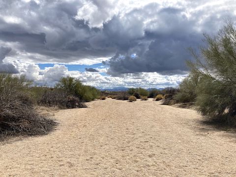
As of two weeks ago, Phoenix had received less than 5% of its normal winter rainfall of 1.5″. Since then, McDowell Mountain Regional Park had storms of 0.79″ five days ago, and 0.31″ earlier today. It was still drizzling when my wife & I arrived at the Trailhead Staging Area around 8:30 a.m., so I waited a half hour before heading out. Due to the fresh moisture, I was hoping to finally find some flowers. 🙏🏻
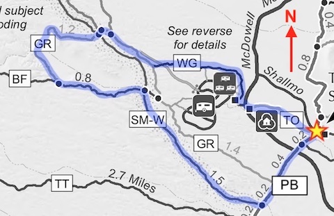
As you face back the way you drove in on Shallmo Dr., this loop starts on the left, by the Pemberton Trail and “To Nature Center” signs. In 250 ft., turn right on Tortoise Trail.
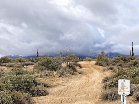
Tortoise Trail, abbreviated “TO” on maps, is rated 🟢 for easy. Wide and smooth, Tortoise Trail “climbs” a mild 100 ft. in 0.7 miles, from Pemberton Trail to the Nature Center on McDowell Mountain Park Dr. Tortoise Trail is for hikers and MTBs only, no horses. Or e-bikes for that matter. None in the park at all. It’s a beautiful thing. 🤗
At the Nature Center, I turned right, up McDowell Mountain Park Dr. In 50 yds., I turned left on Thoms Thumb Dr., towards the E.I. Rowland Campground. (Note the spelling difference from Tom’s Thumb, the nearby rock spire.) In 150 yds., on the right, is the Wagner Trail trailhead, a small paved lot.
Wagner Trail (WG) is rated 🟢 for easy. Smooth singletrack, Wagner Trail gains a meager 120 ft. in 1.1 miles, as it circles the campground. Wagner Trail is also for hikers and MTBs only. Just before it ends at Granite Trail, Wagner Trail crosses a road. Don’t wander down the road to what appears to be another campgound. It’s a maintenance yard, and signs warn it is a Class 2 misdemeanor if you do. 😧
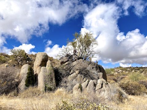
Granite Trail (GR) passes by the No-No Zone so close you could you could touch it. Go figure. Anway, my loop utilizes 1.8 of Granite Trail’s 3.5 easy 🟢 multiuse miles. It rises 130 ft. the next mile, to its high point, before dipping to an unnamed wash with some nice granite boulders, which I assume are the source of Granite Trail’s name. There’s a dry, broken up, cement spring box next to the boulders.
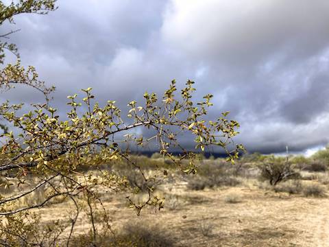
On Granite Trail, I started seeing some decent saguaro. Only flowers were a single ocotillo, past peak, with a few blooms fading to brick red. There was a small burn area, maybe two acres, where the wild fire hopped from creosote to creosote. The clouds had cleared a bit, revealing the McDowell Mountains, and points further north like Granite Mountain. There is a rest bench at the Delsie Trail junction.
There are two rest benches at Granite Trail’s junction with Bluff Trail. I turned left, on the inbound second half of my loop. In the distance, I spotted smoke behind the Lousley Hills, near Fort McDowell.
Bluff Trail (BF) is rated 🟦 for moderate. I assume for MTBs heading the opposite direction. (Bluff Trail climbs 340 ft. in 2.2 miles.) Smooth singletrack, it would be a zippy downhill away from the McDowell Mountains. Multiuse Bluff Trail had a few more saguaro, but still no flowers. There’s a rest bench 200 yds. before Stoneman Wash, which I turned right into after 0.8 miles on Bluff Trail (4.6 overall).
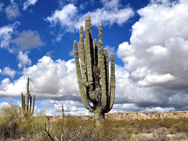
Stoneman Wash Trail (SM-W) is the fourth longest trail in McDowell Mountain Regional Park at 4.4 miles. Stoneman Wash Trail is rated ⬥ for difficult, presumably for being sandy. Walking it was no problem. There’s guide posts all along Stoneman Wash, but it’s more a case of choose your own adventure. I’m glad I did. 🌵
First, I found a nice cluster of scarlet hackberry beardtongue (Penstemon subulatus). It was the only flowers I found, but at least it was something. The highlight of my day, though, came 200 yds. further down Stoneman Wash: A beautiful, prolifically-armed, saguaro. It’s neighbors weren’t shabby either.
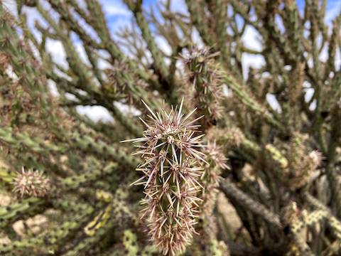
Pemberton Trail (PB) is rated ⬥for difficult, but that must be for it’s western leg, nearer the McDowell Mountains, as it’s eastern quarter is smooth & rolling. Alone all morning, on Pemberton Trail the mountain bikes were out in force, so I kept my head on a swivel. No flowers, and few saguaro, but some nice teddy bear cholla. (So named because they look deceptively squeezeable.)
When I arrived back at Trailhead Staging Area at noon, I was looking forward to a restorative shamrock shake at McDonald’s. Instead, my wife informed me that my SUV’s battery was dead. What a disaster. Suffice to say AI “customer service” is an abomination, and the bean counters who implement it deserve eternal fiery torture in the deepest pits of Hell. 🖕🫵🫘🧮

Directions: From Phoenix, drive east on Shea Blvd. Just over the top of the hill into Fountain Hills, turn left onto Fountain Hills Blvd. Stay on the road 3.9 miles through Fountain Hills. Beware the 15 mph school zone on the edge of town. Just past the school, the same road becomes McDowell Mountain Rd. In 3.6 miles, turn left on McDowell Mountain Park Dr. Entrance fee is $7. Stay on the road as it curves past the nature center. In 3.1 miles, turn right onto Shallmo Dr. Trailhead Staging Area is at the end of the road in 0.8 miles.
Park Map: McDowell_Mountain_Regional_Park_Trail_Map
GPS File: MMRP_Tortoise_Wagner_Granite_Bluff_Stoneman_Pemberton
Distance: 7.46 miles
AEG: 470 ft.
Time: 2h 29m
Rumble Video
Vimeo Video
Hiking McDowell Mountain Regional Park from Preston McMurry on Vimeo.