

My wife and I have been having romantic December getaways in Las Vegas since 2011. We occasionally visit other times of the year, most recently for the Celtic convention last June.
We’ve stayed in Primm (don’t ask), at the Golden Nugget, Sun Coast, JW Marriott, Cosmopolitan, Wynn and Encore. Encore is easily the nicest, especially the Tower Suites. Encore can be quite pricey, but the first week or two of December, especially week nights, is their least expensive rate of the year. So, we splurge a little. 💸
We don’t gamble much, but usually manage to come away with a small profit ($60). Mostly, we visit family, take in a museum, see a show and, for me, hike. This year, it was the National Atomic Testing Museum, Dave Landau (a hilarious comic), and the White Rock – La Madre Spring Loop in the Red Rock Canyon National Conservation Area.
The first time we had our early, romantic, Chistmas in Las Vegas happened to also be the first time I hiked the White Rock – La Madre Spring Loop. (If you clicked that link, you noticed there was only one photo and barely any blog.) Times change. 😁
You can start the loop from one of three trailheads: White Rock Trailhead, Lost Creek Canyon Trailhead and the Willow Creek Picnic Area. The latter are paved access. I have an SUV, so I started from White Rock TH, the same as in 2011.
White Rock TH is also used to access the Keystone Thrust Trail. Alone, Keystone Thrust is 2.4 miles, 600 AEG. If done as part of the White Rock Loop, it will add 2.0 miles and 500 AEG to your hike.
I again hiked clockwise, as I prefer to warm up my legs for a mile or two before I begin climbing. If you hike counterclockwise, the White Rock Loop begins with an immediate 1.3 mile, 600 AEG climb. Not bad, but I still went the other way.
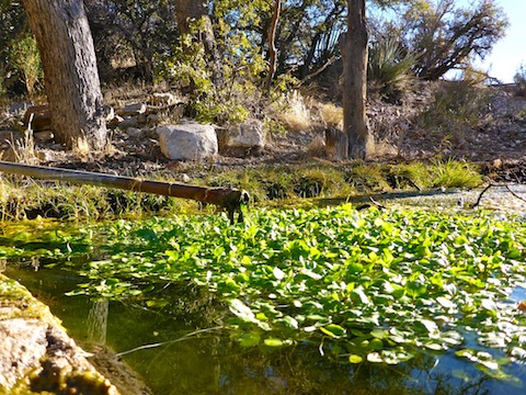
I stopped by White Rock Spring. The spring box was full, and fairly clear, with some floating greenery of the non-slimey variety. Possibly the most interesting thing I saw all day were the seeds / eggs along the edge of the cement box. They looked like large tomato seeds. There were tons of them. Check out my hike video, below, and let me know if you have any idea what they are. 🤔
Back on the loop trail, it descends 450 ft. in a little over a mile to a wide, easily crossed, wash. It is the same wash on which White Rock Spring is located, so if you are feeling adventurous, you could hike the wash, rather than the loop trail, to the crossing.
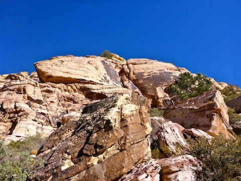
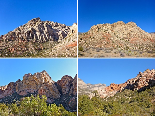
After crossing the wash, the loop trail crosses plateau to the Lost Creek Canyon TH (there is a short access trail), then straight through the Willow Creek Picnic Area. This segment is the closest the White Rock Loop approaches to the White Rock Hills. As the sun will be at your back, or quartering you, it will cast shadows on the boulders, giving you great photo ops.
Unfortunately, the photo ops did not include the petroglyphs I expected, and which signage indicated should have been directly in front of me, at the base of White Rock Hills. Apparently, the Petroglyph Wall Trail (.25 miles, 25 AEG), on the south side of Rocky Gap Rd. has petroglyphs. If I had known that at the time, I would have checked it out. Instead, I was bummed.
Leave the Willow Spring Picnic Area on the now gravel Rocky Gap Rd. I made the mistake of trying to follow a trail, and ended up in a small wet land, inadvertently threatening some protected snail species or another. Sacre bleu!
From the picnic area, the trail follows gravel roads for a little under two miles, and 650 AEG, to La Madre Spring. Follow the plentiful signs, or my attached GPS route, and you won’t take the wrong split in the road. If you skip La Madre Spring, you will save yourself a mile and 350 AEG. (Giving the official loop distance of 6.5 miles.)
A quarter mile short of La Madre Spring, there are two old ranches. All that remains is the foundation and a bit of piping. Looks like they had indoor plumbing via the spring. It’s a shame the feds tore them down, instead of renting them as cabins, because they had sweet views. 😕
La Madre Spring was flowing pretty good, and the water was clear. But I am a wuss, so I didn’t drink it and forgot to dip my toes in it. I was focused on taking photos & video. La Madre Spring had plenty of wet land type grasses, and even an old dam. Getting down in the creek, and improvising a rocky ‘tripod’ got me some decent flow video. 👍
It was a short jaunt back to the loop trail at the base of the White Rock Hills. I passed seven people on their way up, so figured if I was to take a trailside pee, I best do it now, before the circus showed up. Good call. I encountered several dozen more people the final 2.5 miles back to the White Rock Trailhead.
After rejoining the loop trail (or skipping La Madre Spring), it is a 1.3 mile, 500 AEG climb to the saddle at the north end of the White Rock Hills. La Madre Mountain is the towering, barren, grey, escarpment on the west side of the trail. The junipers were loaded with berries. I spent that 40 minutes closely scanning the skyline and crevasses of White Rock Hills, hoping to see some big horn. No such luck. Struck out two straight visits. Still the only big horn I’ve seen in Nevada was a male crossing the road in Valley of Fire. 🐏
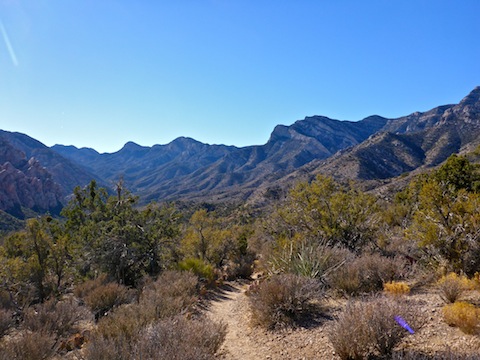
By the time I reached the saddle, I was passing people every few minutes, including a pair of attractive German-speaking ladies. I stopped for a break, and to enjoy the magnificent view back down canyon. Even though I was on a high point, with clear line of sight towards Las Vegas, I had zero bars Verizon reception. Tweeting some hike pix would have to wait.
From the saddle, it is 1.3 downhill miles to the White Rock TH. There some decent views of the Calico Hills and, in the distance, Blue Diamond Hill. But, for the most part, the scenic stuff was behind me. Speaking of which, there were zero flowers on this hike, not even on the few cacti. (Nevada hiking is much less stabby than Arizona.)
The White Rock Trailhead pit toilet was the fullest I’ve seen an outhouse since a boat trip to the Cree indian reservation 300 miles of Winnipeg in 1971. The Cree outhouses had no pits: They let the crap pile up to ass level, then picked up the outhouse and moved it over a few feet. Three foot high piles of poo all along the breakwater. I’m not joking. But hey, at least the White Rock TH had serviced the hand cleanser dispenser! 🙄
On the way back into Las Vegas, we passed some sort of 3-wheel motorized vehicles, with roll bars, that were driving in the bike lane at around 30 mph. (Speed limit was, I believe, 45 mph.) Odd. No idea what they were.
Directions: From the Strip, head west on Sahara for 10 miles, passing over I-215. Sahara bends north, becoming Desert Foothills Dr. Turn left on Charleston Blvd. for 4.4 miles. Turn right onto one way Scenic Loop Dr. After paying the small entrance fee, follow Scenic Loop Dr. for 5.6 twisty miles to the rough turn off for the White Rock Trailhead. Cars should continue on Scenic Loop Dr. for another 1.5 miles, turning right on Rocky Gap Rd., parking at either the Lost Creek Canyon Trailhead or the Willow Spring Picnic Area.
GPS File: White_Rock_La_Madre_Spring_Loop
Distance: 8.34 mi.
AEG: 1,586 ft.
Time: 3h 13m
Hike Video
Hiking White Rock – La Madre Spring, Nevada from Preston McMurry on Vimeo.