

This week my wife and I had our annual romantic pre-Christmas getaway to Las Vegas. As everywhere else we travel, I planned a hike or, in this case an extensive series of very short hikes, ranging from a quarter mile to three miles, round trip. The objective: Nevada’s Valley of Fire State Park.
With out rushing, I thought we could hit all 15 of the visual wonders I identified during my research. My very first plan, which I quickly discarded, considered the possibility of also exploring the ruins of St. Thomas, a ghost town created by the back flood caused by the construction of Hoover Dam in the 1930s. (Lake Mead’s recent record low lake levels have since revealed the ghost town.)
Of the 15 rock formations, petroglyph sites, and petrified logs we hoped to visit, we only got to eight. A ninth, Firecave, I mislocated on my map, so I looked in the wrong place. (Firecave is also the only wonder that did not have some sort of roadside info plaque.)
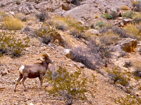
After breakfast at the Moapa Paiute truck stop on I-15 and the Valley of Fire Highway, we arrived at the park’s west gate at 9:00 a.m. A big horn ram greeted us. The info sheet / line map we received — from a ranger, not the ram! ![]() — informed us there were even more wonders, and trails, to explore than we were aware of.
— informed us there were even more wonders, and trails, to explore than we were aware of.
After missing Firecave, we continued around Scenic Loop Road, which is dirt the first mile, to Arch Rock and Atlatl Rock. Arch Rock is a natural arch, and big anough to stand in, but delicate, so I did the right thing and took my pictures from the pullout. Atlatl Rock is accessed by steep metal stairs at the top of which are a number of petroglyphs, many of which were similar to petroglyphs I had previously seen at Indian Spring and Painted Rock. Perhaps the most interesting part of Atlatl Rock was noticing the old stone steps that were previously used to access the petroglyph panels.
There are two campgrounds on Scenic Loop Road, but there are pullouts, parking areas, picnic tables and pit toilets all along Valley of Fire Highway, Mouse’s Tank Road and Fire Canyon Road.
Our next stop was the western set of petrified logs, right across from Scenic Loop Road. It’s a quarter mile loop hike, which even someone with bad feet — like my wife — can enjoy. There were three half-buried logs, surrounded by chicken wire fences. They were tannish white, not the outstanding samples seen in the Petrified Forest, let alone Escalante, Utah. My wife did spot one foot long chunk of petrified wood that was outside the fence.
While hiking the petrified log loop, we noticed a helicopter that appeared to be airlifting material to & from a mesa a mile northeast. As we pulled onto the highway, we noticed they were using the Prospect Trail trailhead as an LZ. I jumped out of helicopters in the Army, so I stopped to watch them for a few minutes.
Our next stop was the visitors center / Balanced Rock. The Nevada Highway Patrol had Mouse’s Tank Road blocked off, but it was for a film shoot. On one hand, I was glad that was all it was, as I would get to go up the road to look at other wonders; on the other hand, I like to see bad guys get justified. You can see Balanced Rock from the road, but it is best viewed from the trail, which is only a quarter mile round trip. As we left the lot, a bus load of Chinese tourists showed up; we spent the next two hours barely a step ahead of the horde.
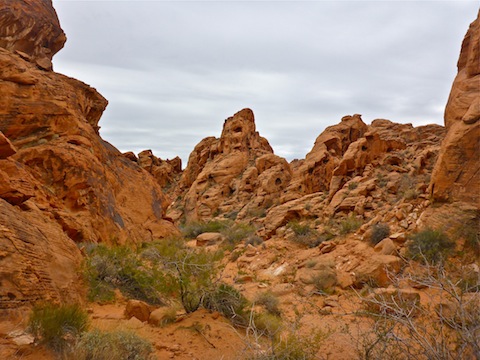
The drive up Mouse’s Tank Road brings the wierd & spectacular rock formations as close as they get without stepping out of your car. The highlight of a trip to the Valley of Fire is less in specific wonders, than in the overall beauty of the mesas, hills, mountains and canyons.
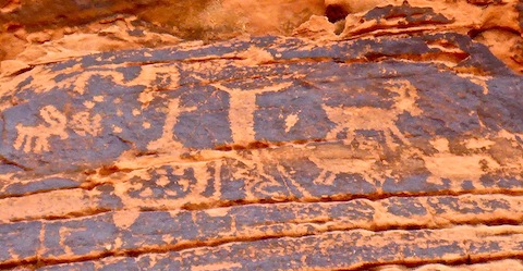
Next on my agenda was a hike to Mouse’s Tank itself. The tank is named for an outlaw who holed up there in the 1890s. The trail is along a wash with deep, soft sand, so it will be slow going for most folks. I had to chastise the son of a foreign couple who was picking up & throwing rocks. (Removing objects from their natural context borks the archaeological record.) The trail had some awesome petroglyph panels, one that was sixty feet long. The tank itself is over a sheer 30 ft. dryfall. I scrambled up some rocks to the side for a better view down canyon. I would have liked to explore further! Back at the trailhead, I got to stress the Chinese bus driver backing his bus into the parking lot, mere feet from my car. (I’ve watched enough Chinese drivers on LiveLeak to know that could have ended badly … very badly.)
It was chilly, and overcast, making photography difficult with a cruddy pocket camera. The lighting never improved. Earlier, we had considered heading back to Las Vegas, and coming out the next day. (Good thing we didn’t as Vegas got such heavy rain on Thursday there were flooded intersections downtown.) Instead of doing some more of the hikey hikes I had planned, such as the Ephemeral Arch Trail, we decided a good compromise would be to quickly hit some of the roadside photo ops, before heading “home”.
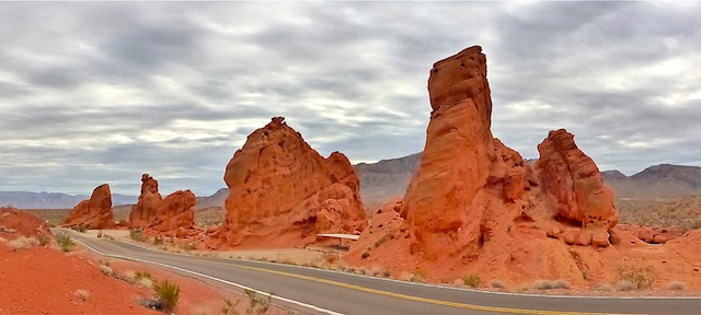
So, it was on to the Seven Sisters, the Clark Memorial and Elephant Arch.
While the Clark Memorial can be seen from the road, I did walk the few hundred yards out to it. Though I had not seen a single roadside memorial all day, it was far from the last I would spot.
Like Balance Rock, Elephant Arch can be viewed from Valley of Fire Highway, but the best angle for photography is slightly uphill, which requires a short hike from the east entrance parking area. I had to lay flat on my back to get a sky-filled angle, as an upright shot would have filled the arch with distant hills. That might work with a very tightly focused, small f-stop, photo but not with my pocket camera, and certainly not with such poor lighting. That said, Elephant Arch definitely looks like an elephant!
Rather than heading back the way we came, into Las Vegas via I-15, we took the scenic loop on NV-167, through the Lake Mead National Recreation Area. Signs say there is a fee, but the guard shack was not manned. NV-167 was a pleasant drive with almost no traffic. Rather than continue towards “Lake Las Vegas”, a typically tacky “attraction” that when I was last out there a few years ago was apparently abandoned, we instead turned west on NV-147, towards North Las Vegas. (A scenic journey in it’s own right. ![]() )
)
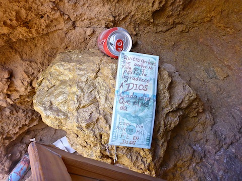
The next roadside memorial I spotted was just past the NV-167 intersection with NV-147. At first I thought it was simply a graffitied boulder, but a quick investigation revealed a typical memorial of a crucifix, candles and cans of beer in an alcove high on the boulder’s backside.
Further up NV-147, also known as Lake Mead Blvd., at the top of the pass overlooking North Las Vegas, there were a ton of roadside memorials. I photographed seven, and I swear I saw a few more, but lost track of them. It was easy to see why there were a lot of roadside memorials, as there were several high speed curves, with elevation change, and most likely copious alcohol consumed either in Sin City’s casinos or boating on Lake Mead.
On the way through North Las Vegas, we saw a homeless Santa and what appeared to be a burglary in progress, but the highlight was the absolutely massive homeless camp along north Las Vegas Boulevard, near the Woodlawn Cemetery. My wife agreed I was not exaggerating about how many there were. (A few years ago I had passed through the hood after getting off the wrong ramp on I-15; a cop, probably wondering what a white guy in a nice car was doing in that hood, followed me for the next several miles.) As a bonus, we saw one apparent drug deal, and also one guy who appeared to be taking a dump on the sidewalk. ![]()
GPS File: Valley_of_Fire_State_Park
Distance: 3.00 mi.
AEG: 400 ft.
Valley of Fire Video
Valley of Fire State Park, Nevada from Preston McMurry on Vimeo.
This is a wonderful day trip with many different surprises.