

West Leonard Canyon is an eight mile long canyon, located on the Mogollon Rim between Hospital Ridge and Knoll Ridge. West Leonard Canyon starts on Rim Rd. at Lost Lake, draining north — as do all top of the Rim canyons. At five miles, Middle Leonard Canyon empties into it. At eight miles, West Leonard Canyon joins with East Leonard Canyon to form, simply, Leonard Canyon, which eventually empties into East Clear Creek at Leonard Point. 🏞
An eight mile canyon crawl, followed by trudging eight miles on forest roads back to the trailhead, is more than I can handle. (Not to mention daylight would be at a premium.) I learned my lesson two years ago in Willow Springs Canyon. Instead, my plan for today was to hike down West Leonard Canyon to the junction with East Leonard Canyon, climb out, then return on FR 300H.
When I arrived at Myrtle Point, people were already camping at the intersection of FR 300H and FR 9735T. So, I continued north on FR 300H to the next camp spot, which was empty. Turns out it is a better trailhead for West Leonard Canyon, as the top of the canyon is only a hundred feet away.
I was expecting West Leonard Canyon to be about 2½ miles of canyon crawling, followed by 1½ miles meadow walking, finishing with another mile of canyon crawling. I had heard there was a “6 out of 10” deadfall obstacle in the canyon, but was unsure where. Concerned about another Crackerbox Canyon, I kept a close eye out for bail points. (See the GPS file attached below.)
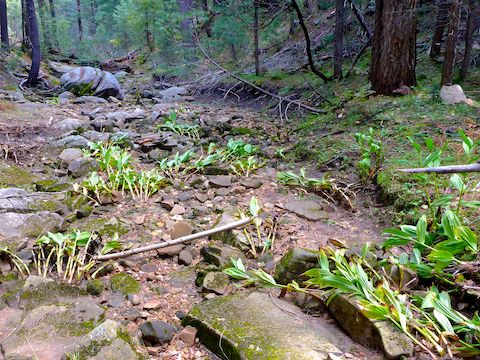
As I always do when canyon crawling, I try to stay as close to the bottom of the canyon as possible. If I can save a bit of time, or avoid risk of injury, crossing a shelf instead, I will take the path of least resistance. That said, the first two miles of West Leonard Canyon were not bad at all, with minimal deadfall. 👍
Just over ¾ mile, I found two sets of caves, less than 200 ft. apart. The first, 20 ft. easy feet above the bottom of West Leonard Canyon, was big enough for three people and their gear. The other two caves were only big enough for one person each.
I started noticing dead, brown, maple leaves on the ground, with a small grove 1⅔ miles down West Leonard Canyon. But up high, the maples were nearly devoid of leaves. Of the few leaves remaining, a fraction had fall color. Weird, because peak fall color is around the first week of October. 🤔
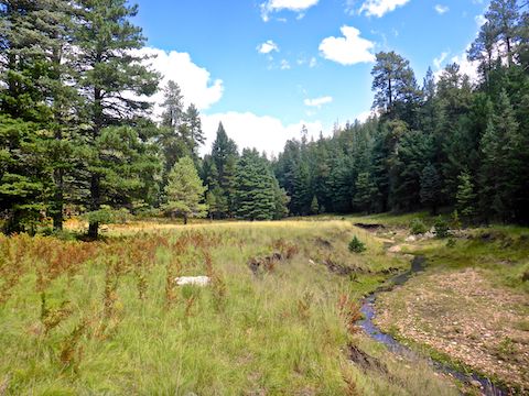
The transition from mostly canyon crawling to meadow walking occured at 2¾ miles, just past a small check dam created by wire mesh. I hiked the first mile of West Leonard Canyon in 37 minutes, the second mile in 38 minutes, but the next ¾ mile in 50 minutes. Although that last section was more congested, it was not bad.
The extra time was more a function of scanning for bail points and taking lots of pictures. (175 on the day!) Besides the flowers below, I also photographed alpine leafybract aster, ragleaf bahia, Richardson’s geranium, Apache lobelia, and several fungi I have no clue about.
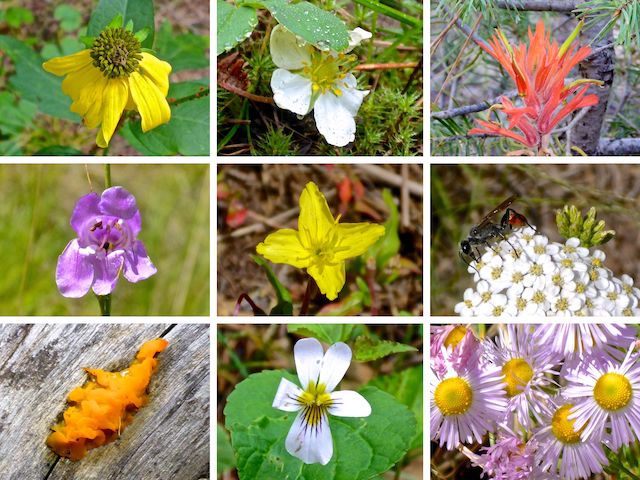
Top Row: coneflower, Virginia strawberry, foothill paintbrush.
Middle Row: wandbloom penstemon, silky evening primrose, western yarrow.
Bottom Row: orange jelly, Canada violet, fleabane.
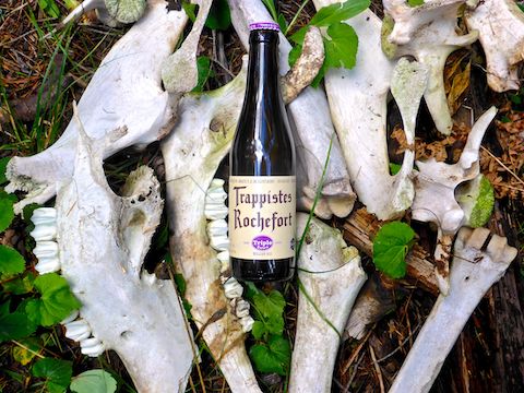
I often find elk bones while canyon crawling the Mogollon Rim. I did not find a rack, like Upper Miller Canyon, but I did find a nearly complete skeleton, scattered over less than a hundred feet. No meat on the bones, but it still must’ve been a fairly recent kill, as usually the bones are too widely scattered to visualize the complete animal.
I also found four mylar balloons. You know, the balloons people release by the jillions at birthday parties and during the memorial at the end of every episode of “The First 48”. The Mogollon Rim seems to be a cosmic magnet for the things. 🎈
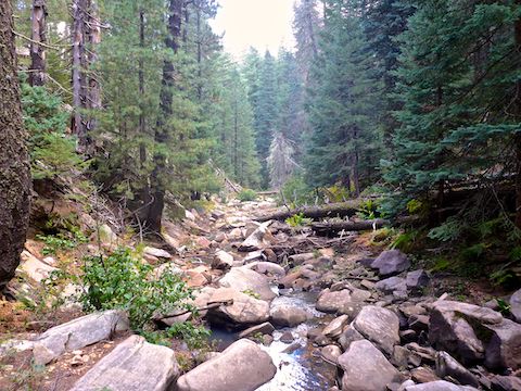
Having crossed the 1¼ miles of meadows in a leisurely 45 minutes, I began the final mile of canyon crawling. As I headed down West Leonard Canyon, still water turned to trickles, puddles into pools. Some up to two feet deep, but mostly avoidable. Even the few wild tangles of deadfall were not an issue. I never did find the “6 out of 10” deadfall obstacle. I bushwhacked the final 1⅓ mile in 68 minutes.
Those recent hikes up North Mountain paid off: Following nearly the same route out of the Middle Leonard Canyon as I did last year, I made it to the top six minutes faster. After ¾ mile of mild cross country hiking, I picked up FR 300H. It was nearly 2:00 p.m. by the time I took my first real break, 20 minutes for lunch, on a log just shy of eight miles.
Even though today was a beautiful, partly cloudy day — no downpour like last year — there were still a number of large puddles along FR 300H. Since I was walking, I settled for ripping through the puddles driving back on Rim Rd. instead. Heck, I even do that cruising down 12th St. 😁
After refreshing at Woods Canyon Lake with ice cream and beer, we stopped at Culvers in Payson for a proper meal on the way home. No custard at the latter, because I was practicing “restraint”.
Directions: From Phoenix, head north on AZ-87, the Beeline Highway, into Payson. West Leonard Canyon is dead center on Rim Rd. So, the time from Payson to West Leonard Canyon, is the same whether you drive north through Pine and Strawberry, then east on Rim Rd., or if you drive east on AZ-260, then west on Rim Rd. I did the latter, to avoid blinding early morning glare driving east on Rim Rd: Drive east on AZ-260 for 29 miles. After cresting the Mogollon Rim, take the first left onto FR 300 / Rim Rd. In 3.2 miles, at the Woods Canyon Lake intersection, Rim Rd. changes to car-drivable dirt. 9.4 miles from AZ-260 is a t-intersection. Turn left. (Right is FR 34 to Winslow.) In 12.0 miles, a mile past the Knoll Lake turnoff, turn right onto FR 300H. Park as soon as you find a good spot.
GPS File: West_Leonard_Canyon
Distance: 10.78 mi.
AEG: 757 ft.
Time: 4h 32m
Hiking Video
Hiking Mogollon Rim @ West Leonard Canyon from Preston McMurry on Vimeo.