

Another week, another search for a hike that isn’t over 100 degrees, isn’t threatened by a Biblical deluge, is within three hours of base camp, is 8-10 miles, and somewhere between 1000-2000 AEG.
Sedona looked like it was least likely to rain on Thursday, but I was just out there a couple of weeks ago, hiking Brins Mesa Loop.
My next idea was to hike something along the Mogollon Rim, which always gets afternoon rain during monsoon season. But if I did something at the lower end of my desired distance, maybe I could get done early enough I could avoid everything but a light drizzle.
I looked at a loop of Strawberry Mountain, which would be about seven miles and 1,400 AEG, but couldn’t finish my planning in time. (I go to bed early.)
Finally, I settled on another excursion down Pine Canyon Trail #26, except this time, rather than continuing all the way to the Arizona Trail in the village of Pine, I would instead divert onto the Bearfoot Trail #13 to Strawberry, when I reached Camp Lo Mia.
This hike starts by heading south, from the Cinch Hook Trailhead on FR 6038, towards the Mogollon Rim. I quickly noticed that the barb wire fence along the left side of the jeep trail appeared to have been repaired / extended / added. If it was there a year ago, I don’t remember it being that long or in that good a condition. At one point, it was wrapped around a tree, but with wood blocks as buffers, so the tree could grow without absorbing the fence.
After a half mile through tall pine trees on FR 6038, Pine Canyon Trail #26 begins a series of at least a dozen switch backs to the bottom of Pine Canyon. The switchbacks lose about 700 ft. in .75 miles. (The trail continues descending, but at a more sedate grade, of 600 ft. in the next two miles, to Bearfoot Bridge.)
I could hear Pine Creek from the top of the Rim. That had me wondering if I would be able to cross the creek, or if it would be a raging torrent like the one that killed that poor family in nearby Ellison Creek last week.
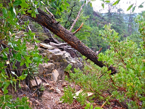
The switchbacks descend through mixed vegetation: manzanita, scrub oak, other leafy plants I don’t know the names of, scattered small prickly pear, a fair number of succulents, and occasionally tall & dense grasses. The surface is rocky and often covered with leaf litter. Despite the recent heavy rain, Pine Canyon Trail #26 was not muddy and footing was never an issue. However, plant droplets had me soaked by the time I reached the bottom of the switchbacks. I only had to duck one fallen tree, but there were several more hovering just upslope. Avoid grabbing them, or putting weight on them.
Halfway down the switchbacks, I saw some colored bits in the dirt & leaf litter. I kneeled down, discovering there were scads of plastic beads. Thankfully, who ever dropped them on the trail also dropped a small plastic tub. It took me about 15 minutes to pick them all up. It also inspired my hike video’s music selection: 💐 & 📿.
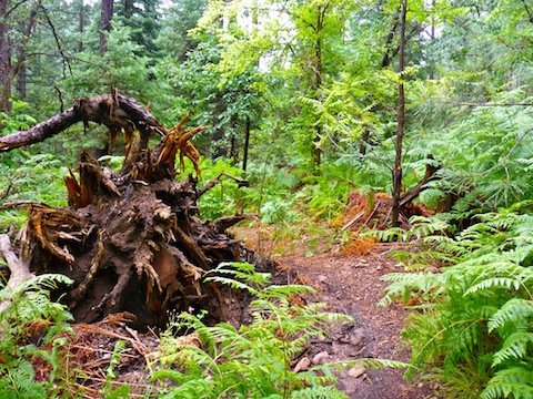
Once at the bottom of the switchbacks, Pine Canyon Trail #26 is again in a pine forest, but this one dense with low vegetation and fallen trees, some as large as 30″ diameter. The trail winds along the west side of Pine Creek, crossing several side canyons, and many fallen, uncut, trees. There are several fern patches. By the time I got to Pine Creek, I was even wetter.
Pine Creek did appear up a bit, but not much. It was nowhere near a raging torrent. The massive tree that previously served me as a bridge, did not appear safe to cross, so I searched a bit for a dry crossing. There were too many trippy plants to either side, and I was wet anyway, so I rock-hopped across.
South of Pine Creek, the trail’s quality significantly increases: It is wide, flat, smooth, obstacle free and — despite recent heavy rain — not at all slippery. Obviously, it has been optimized for 12 year old campers. 😉
New signage has been installed all along Pine Canyon Trail #26. I noticed a sign for Darling Rocks, which I do not recall, but decided against diverting as I had no idea how long, or high, I would have to hike. I did check out Parsnip Spring, which has been hidden by recent vegetation growth, but was at least audibly trickling. I also stopped by Tiny Cave, where I took my first break. Lacking hundreds of 12 year old girls, it was blissfully quiet, the only sound the peaceful rush of Pine Creek. 😎
Pine Canyon Trail #26, between Cinch Hook Trailhead and Camp Lo Mia, is one my Top 10 Arizona Hikes. 🤗
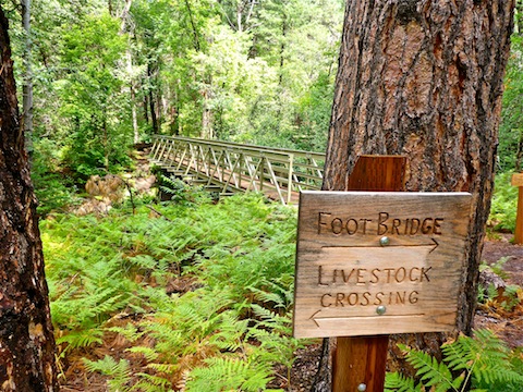
The recently installed Bearfoot Bridge is a half mile south of Tiny Cave. The bridge has a dedication plaque and some bear prints in the cement. It’s a really nice build. Apparently, there is also a “livestock crossing”, though I have never seen any cattle or sheep in Pine Canyon, while neither elk, deer nor bears comprende ingles.
As soon as the Bearfoot Bridge crosses Pine Creek, the terrain changes: Bearfoot Trail #13 immediately begins climbing, but at a mild angle. The vegetation gets more scrubby. There are some good shade spots dotted along the Bearfoot Trail’s length, but it is more in the open, and there are no ferns or other wet undergrowth. At the same time, the cloud cover began breaking a bit, letting the hot sun beam down upon me. Despite the trail’s sun exposure, it was quite slippery, due to a thin mud layer, in many spots.
All along Bearfoot Trail #13 there are sections of purposefully laid flat rocks. In some cases, they are to create erosion-free crossings for shallow drainages, in others they are used as pavers. Some particularly large ones are stacked to make a relaxing bench under a shade tree a mile southeast of Strawberry.
The wierdest thing I saw all day happened when I stopped to admire an oddly twisted manzanita. As I looked up — it was quite high — I spotted half a deer leg hanging in its branches. 😳
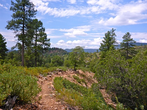
Once Bearfoot Trail #13 gets up a couple of hundred feet, it starts twisting to an absurd degree. More twists than the plot of a daytime soap. There multiple twists where one side of the twist is only only 10 yards, and less than 10 ft. elevation difference, from the other side of the twist. One twist, just west of Camp Lo Mia, winds over a small hill, giving a panoramic view from the head of Pine Canyon to Milk Ranch Point.
The trail also drops, or ascends, several contours, for reasons I could not fathom, when it seems like it would have been easier to follow a contour. Those odd ups & downs add up to 2/3s of this hike’s total gain. Not to criticize, because the trail crew really did a fantastic job. 👍
As Bearfoot Trail #13 traces Pine’s northern edge, it cuts through a long grove of manzanita and other scrub. Judging by the 18-24″ height of the plants, I thought it looked like a 10-15 year old wildfire. But after checking satellite view back at home, it appears instead to be a roughly ~200 yd. wide controlled burn to create a firewise community barrier. Might be time for another burn.
Continuing in satellite view, I scanned east along the rim, noticing most of the other communities — such as Beaver Creek Estates, Ellison Creek Estates and Bonita Creek Estates — had similar buffers. That’s probably what saved Bonita Creek during this year’s Highline Fire. (When I hiked the area in 2013, a firewise buffer had still not been created, which was shocking considering what happened to Bonita Creek during 1991’s Dude Fire.)
Since I started spending more time photographing flowers, I’ve figured out that they are one of the best places to look for wildlife. (Bugs, obviously, not mammals.) Bird song serenaded me throughout the day. During one break, I tried to lure the birds in by scattering crushed vinegar chips, but they weren’t buying it. At various times, I saw deer, elk and bear scat, but the only big critters I saw were a pair of female elk having lunch across AZ-87 from Old Country Inn in Pine, where my wife & I stopped for post-hike linner and rehydration.
Directions: From the Loop 202, head east on Shea, through Fountain Hills, to AZ-87, the Beeline Highway. Head north for 79 miles, through Payson and Pine. On the north side of AZ-87, just as it turns west into Strawberry, is a small parking area. If you are doing this as a shuttle or key-exchange hike, drop one vehicle there. Continue nine miles north, over the Mogollon Rim. One mile after the AZ-260 intersection, as AZ-87 bends north, there is a pull out on the east side of the road. That is FR 6038, the north trailhead.
GPS File: Pine_Canyon_Bearfoot_Trail
Distance: 10.16
AEG: 810 ft.
Time: 3h 57m
Hiking Video
Hiking Pine Canyon & Bearfoot Trail from Preston McMurry on Vimeo.
Lovely greenery–in Arizona!!