

Last week on Tuesday and Wednesday it hit record highs for the day: At 121°, within one degree of Phoenix’s all time high, set on June 25, 1990. (Ironically, the day I moved from Arizona back to Green Bay, which that same night experienced a biblical deluge, with Bairds Creek so high we crossed the creek when we crossed the bridge.) I’m not sure what my backyard reading was — I was too tired from travelling to North Carolina to check — but last June, I recorded 123.8! Yeah, June in Phoenix gets hot.
It remained in the high teens the rest of last week. Places up north, at higher elevations, like Prescott (5400 ft.), the Mogollon Rim (7000 ft.) and even Flagstaff (also 7000 ft.) were into the high 90s. The hottest I ever hiked was 107° three years ago on the Walkin’ Jim Trail, and I had no desire to do that again. So, I skipped my usual Friday big hike.
This week, Tuesday and Wednesday were supposed to be “cool” days, with highs in Phoenix topping at 107°, with the higher elevations about 15° lower. Since high temperature in Arizona is usually around 3:00 p.m., I could drive a few hours north and get in an eight mile hike before the mercury hit 90°.
It’s been seven months since I hiked in Sedona, up Oak Creek Canyon, so I figured a return was in order. Like back then, I considered Boynton Canyon, but decided to save it for a fall colors hike. Instead, I opted for a hike I had not done in five years, the Brins Mesa Loop.
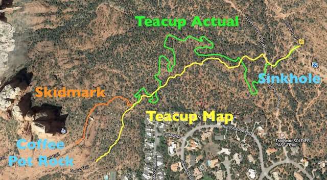
The Brins Mesa Loop comprises parts of the Cibola Pass Trail, Jordan Trail, Sink Hole Trail, Soldier Pass Trail and Brins Mesa Trail. The loop is a tad under five miles and hair over 800 AEG, with only one decent climb, either way, so I threw in a few extras: First, I would head west from the Devils Kitchen Sinkhole on some combination of Teacup Trail and/or Skidmark Trail, to get a closeup view of Coffee Pot Rock. Second, I would check out the Soldier Pass Arches.
In 2012, New Years Pam and I hiked the loop counterclockwise. That puts the steepest climb, either direction, right up front, about 400 AEG in .40 miles. I like to do a few miles before I start climbing, to get my muscles warmed up. Also, more of the intesresting stuff — such as the Devils Kitchen Sinkhole, The Mitten rock formation, Morning Glory Spire, or the Seven Sacred Pools, are in the southern half of the hike. So, I hiked clockwise, which also meant the sun would be chasing my back, theoretically making for better lighting.
The century plants were in glorious bloom through the hike, with the best example right in the parking lot at the Jordan Road Trailhead. (As it is referred to on Google Maps; signage at the trailhead refers to it as the Jim Thompson Trailhead.) After taking a few pictures, I headed out.
The trail immediately splits in three: One to the left, one to the right, with the right hand option itself splitting a few yards later. Left-to-right, the trails are the Jordan Trail, Cibola Pass Trail and Brins Mesa Trail. Despite having a GPS with me, I still managed to turn the “wrong” way, heading down Jordan Trail.
The sun was catching the manzanita just right, but I was not seeing the rock formations I expected (The Mitten and Morning Glory Spire). I went on a few minutes longer, but still no rocks. I thought about just continuing on Jordan Trail, as eventually it would loop back around, connecting to the other end of Cibola Pass Trail, but decided against it: I was on a fairly tight time schedule — lunch with cousin & her family at 1:00 p.m. up in Oak Creek Canyon — so while the extra exercise would have been good, losing time would not. I headed back to the trailhead.
Back at Jordan Road Trailhead, properly oriented, I headed west on Cibola Pass Trail, which is .70 miles of nice trail surface before it connects up to the other end of Jordan Trail. The “pass” itself, is barely 125 ft. above surrounding terrain. (Which makes the saddle behind my house look like the Khyber Pass.) The most mitten-like view of The Mitten, came very quickly, while still on its easterly side, before reaching the top of Cibola Pass.
The best views of Morning Glory Spire some as Cibola Pass Trail reconnects to Jordan Trail, where the route crosses slickrock as it approaches the Devils Kitchen Sinkhole. Even when on normal dirt trail, other than a few century plants, flowers were quite rare.
The formation of Devils Kitchen Sinkhole in the early 1880s was witnessed by local settlers. It expanded just over 100 years later, in 1989, when a big chunk of the north wall separated. I’m surprised I don’t remember that, as I was attending Northern Arizona University, in nearby Flagstaff, at the time. There was also a collapse in 1995. The collapsed cave system, below the sinkhole, may be as deep as 660 ft., but visibly Devils Kitchen is approximately 150 ft. long, 90 ft. wide and 70 ft. deep.
After checking out the sinkhole, I made my first planned diversion 😜, heading west on Teacup Trail, which starts as jeep trail. According to the map, Teacup heads southwest, fairly straight for a half mile before Skidmark Trail splits off from it. Instead, Teacup was perhaps the twistiest trail I’ve ever been on. Given all the mountain bike tracks, Teacup had obviously been rerouted and optimized for MTBs. (More twists = more gradual elevation gain.) It was actually a mile to reach the intersection, which is located at a small boulder pile. Skidmark Trail is not obvious, but it is there. You just have to look close. As the views of Coffee Pot Rock were no better up close, and time was a factor, I headed back to Devils Kitchen.
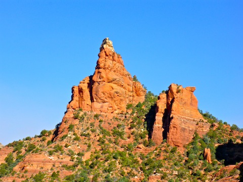
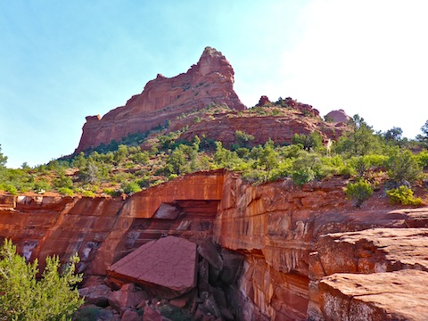
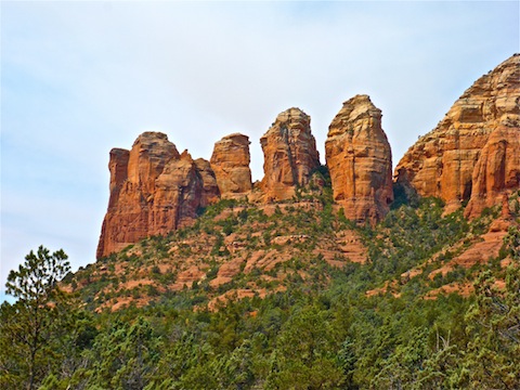
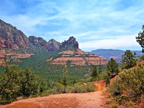
Back at the sinkhole, I started north on Soldier Pass Trail. There is even more slickrock on this trail than there was east of the sinkhole. Heading north on Soldier Pass Trail provided much better perspective on Coffee Pot Rock than did Teacup Trail. Whereas from Teacup, Coffee Pot looks like just the face of a cliff, from Soldier Pass Trail, it instead looks like a series of tilting dominoes. You can see Coffee Pot is composed of four or five separate spires.
The most scenic part of Soldier Pass Trail is the Seven Sacred Pools, a series of pothole cascades in a short gulley worn through the slickrock. The water was not flowing, but lining the Seven Sacred Pools up with Coffee Pot Rock makes for a great photograph, if shot in vertical mode. (As I found on Google image search, I was not the only one to have this realization. 😁)
North of the Seven Scared Pools, I passed a lady heading south, who asked me if I had seen her camera. No, sorry. A couple of minutes later, I saw her camera in a bush. I thought about chasing after her, and I thought about taking it with me, but decided instead to simply hang it higher, making it more visible. (Since, as far as I am aware, cameras do not carry the same info as mobiles, which will allow one to contact the owner.)
Just before the trail begins climbing to the top of Soldier Pass, I instead turned up a side trail towards the Soldier Pass Arches. It is about a 350 ft. climb, with 300 of that coming in the final eighth of a mile. Steep. Along the way, I said hello to a guy who, it turned out, was the husband of the lady who lost her camera. So, I told him where the camera was, so when they hooked back up, she would be able to find it. I did my good deed for the day. 👍
Soon after that, I bailed. I was close to the arches, but keeping an eagle eye on my time, and it was getting short. I had started at about 7:40 a.m., with a hard end-ex of 12:15 p.m. It was already 10:50 a.m. and I had almost three miles to go.
By the time I got back to Soldier Pass Trail, I was getting tired, and I still had to climb to the top of the pass. I took a quick break, then started up. It’s about a 300 ft. climb in a half mile, all exposed to the sun, where the temperature was well above what was predicted for the day. (95° at 12:30 p.m. rather than 92° at 3:00 p.m.!) 😓
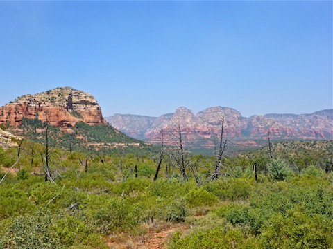
I soon connected to Brins Mesa Trail, and booked across Brin Mesa’s burn area. Most of the trees were killed off in 2006, while the shrubbery have recovered, but the few survivors provided welcome relief. The trail across the mesa is dirt & rocks, but still not bad footing. The descent down Brin Mesa’s east slope is across a half mile of steep slick rock, before re-entering the tree line. With .75 miles to go, I took another quick break, texting ahead to my always patient wife to let her know I would be back at the Jordan Road Trailhead in about 15 minutes.
In the end, it took my old ass about 20 minutes, despite what felt like hauling ass. I arrived about 12:25, had a quick pee, rehydrated, threw my gear in the back, and off we flew to our lunch date.
Directions: From Phoenix, head north on I-17 to exit 298. Take AZ-179 north 15 miles to the traffic circle in the middle of Sedona. Take the 1st exit off the circle, north on AZ-89A. In 0.3 miles, turn left on Jordan Rd. In 0.8 miles, Jordan Rd. ends at a t-intersection. Turn left on Park Ridge Dr. In 0.7 miles you will arrive at the trailhead. The final few hundred yards are a bit bumpy over slickrock.
GPS File: Brins_Mesa_Loop
Distance: 5.00 mi.
AEG: 850 ft.
Time: 2h 30m
Hiking Video
Hiking Brins Mesa Loop from Preston McMurry on Vimeo.
Another good one! All your posts and videos are becoming quite a resource for people who want to go hiking.
That is my hope. 🙂