

Today, I set out to do the hike I skipped a few weeks ago do to me having a cold and it being below freezing up in Yavapai County: Hike from FR 682, near Wagoner, southeast up Cellar Springs Creek canyon, maybe mine exploring along the way, to Indian Springs Camp, then back along FR 682 to my trailhead. The objective of my exploratory hike being to see if I would be able to get my SUV deeper into the mountains, and thus be able to use Indian Springs Camp — a corral and line shack — as a base to explore remote areas of the McAllister Range and Bradshaw Mountains that hiking distance & rugged terrain has so far precluded. (Paxton Place was easy pickings access-wise.)
Driving my wife’s Subaru Forester, we had no problem with FR 682 to Cellar Springs Creek. It is even car-drivable, with caution, as far as the windmill at the second gate. On the way south on Wagoner Road, it was obvious there was a hunt going on. What for, I don’t know. When we arrived at the third gate on FR 682, at Cellar Springs Creek, there was a truck & horse trailer parked in the pullout. It was from Maughan Ranches, who own most of the ranches in the between Wagoner and Peeples Valley. (500,000 acres in all!) I didn’t want to park right next to someone else in that remote an area, FR 682 looked pretty rocky past gate 3, and Cellar Springs Creek was pretty brushy and I didn’t want to be thrashing around down range of someone with a rifle. So, I bailed.
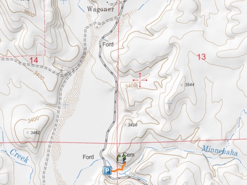
On one of my topo map recons, I had noticed a cemetery on a bluff above Minnehaha Creek, across Wagoner Road from the Cooper Ranch. I had it in my plans to check it out sometime I was in the area, but either forgot or was too tired. (Like after my Silver Dollar Mine exploration.) Since my wife & I were in the area, and I hadn’t hiked a foot yet, we stopped by to check it out.
Oh, man, I got tore up by catclaw. And that even though I was following cattle trails up the small bluff. Brutal. 🤕
The cemetery is not really visible on sat view, so I was expecting it to be a small family plot, or maybe a miner’s grave. It did turn out to be for a single burial, but surprisingly for a U.S. soldier, Captain J.C. Hunt of the 1st Cavalry. Most interesting of all, is that it was not marked by a faded wooden cross, but a typical U.S. military gravestone. I took some photos — see the video, below — saluted, and headed back to the SUV.
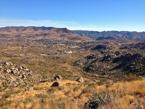
Since were in the Weaver Mountains area anyway, and when I am up there I always stop at the T-Bird Cafe — home of Arizona’s best pizza — I decided that as an alternative, I would instead hike the Granite Mountain Hotshots Memorial State Park.
The first time I hiked Yarnell Hill to the hotshots’ deployment site was 13 months ago, just after the park opened.
I felt a bit guilty hiking the trail for exercise rather than a pilgrimage. It climbs 550 AEG the first mile, levels out across a short saddle, climbs 650 AEG in the next mile, and then is level again the final half mile to the overlook. Because my day had now been much delayed, I skipped the 1.5 mile, 500 AEG, round trip down to the deployment site.
I blasted the first 1.5 miles, then my fat ass began running out of steam, and I slowed the last mile to the overlook. In all, it took me 1h 17m. After a 20 minute break, drinking a beer, and chatting with another hiker, I headed back down hill. I hauled the whole way, even jogging parts, making the 2.5 miles in only 56 minutes. 🏃🏻♂️
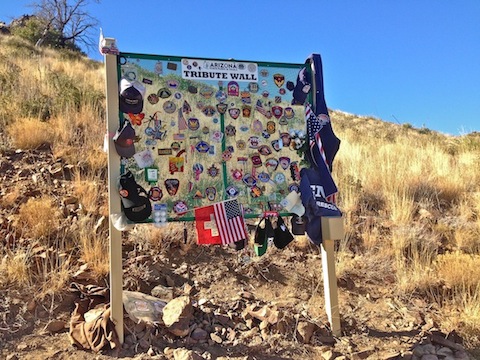
Despite not taking nearly as much time at each of the 19 memorials as I had before, I still stopped to read a line or two, and in some way tried to remember them all. Most of the memorials had had small rocks placed around them, and now also had a white flower. Some had other mementos left behind.
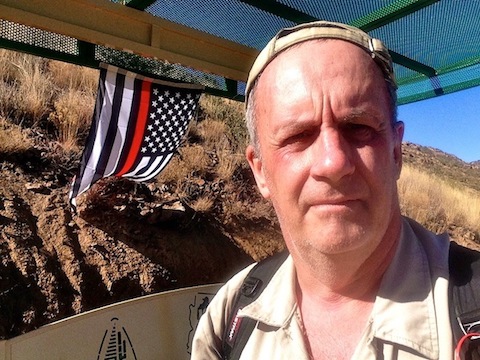
At the overlook, there was a firefighter memorial USA flag, black with a single red stripe. There was also a tribute wall, where many fire and police departments had left their patches.
Unfortunately, not all the changes were positive. Most of the many switchbacks have been cut so heavily that it is often hard to tell the difference between the originally constructed trail and the ones left by incredibly lazy people. Besides the immediate damage to the trail, it increases the threat of erosion, causing even more damage. 😟
But that was not the worst insult.
That would be the insensitive clod who left their bag of dog shit on the trail.
Yarnell Hill is hallowed ground. Treating it like it is a suburban Phoenix trail is unconscionable. To think I felt guilty even being there, and they felt nothing about desecrating it!? 🤬
GPS File: Wagoner_Cemetery
Distance: 5.60 mi.
AEG: 1,330 ft.
Time: 2h 24m
Wagoner Cemetery Video
Wagoner Cemetery from Preston McMurry on Vimeo.