

I have been hiking the C&O Canal off & on for a few years now, but this year I began day hiking it end-to-end. My first outing, last Easter, was from Georgetown to Carderock Recreation Area, milepost (MP) 0.0 to 10.5.
Normally, when visiting family in Hagerstown, we fly in on Thursday, and back out on Monday. That only leaves one day for hiking. Beginning this Halloween, we are staying five full days. That gives me time to do two C&O Canal segments, while having two days recovery time in between. Two trips per year, and two hikes per trip, are the only way I will be able to complete the C&O Canal all the way to MP 184.5 in Cumberland before 2025, when my wife will be old enough that I wouldn’t feel confortable with her dealing with the complications of a shuttle hike. 🤔
If I did out & back hikes, I would either need to double my distance per hike to 15-30 miles / segment or only do half segments, doubling the number of hikes I would have to do. Even though the C&O Canal is flat, I haven’t hiked over 25 miles since I was a 20-year old paratrooper. Now, that I am a middle-aged fat man, 30 miles is a bridge too far.
My plan for this week was to hike from Carderock Recreation Area (MP 10.5) to Pennyfield Lock 22 (MP 19.6) today, then hike from Lock 22 to Edward’s Ferry (MP 30.9) on Wednesday. Roughly halfway on today’s hike, I would meet my wife at Great Falls Tavern, so we could ride the historical Charles F. Mercer canal boat, which runs only on weekends.
It was predicted to be rainy today, but I really couldn’t put off the hike to Monday or Tuesday, and still have time to rest for the hike from Great Falls to Edward’s Ferry on Wednesday. Plus, I was hoping it would clear up. The drive east on I-70 was foggy & rainy, and there was an accident at the summit of South Mountain. 🚨
Driving down I-270 from Frederick towards D.C., the rain got heavier and heavier. It was quite tense, as I could not figure out the wipers on my rental. (I was turning them down, when I thought I was turning them up!) I was basically driving blind. Thankfully, there is no rush hour on Sunday!
The rain stopped by the time we arrived at Carderock. Wearing a just-in-case rain jacket, off I went.
According to Murphy’s Laws of Combat, no plan survives first contact with the enemy: No sooner had I started down the C&O Canal towpath than it began drizzling.
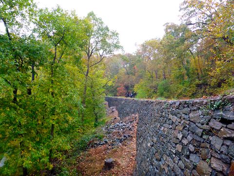
At MP 10.5 on the Potomac River side of the towpath, there is a well preserved stone wall buttressing the C&O Canal, which flows through the Potomac’s ancient channel. Due to Great Falls, here the Potomac is now 70 ft. below canal level, so engineers had to cradle the canal until they could gradually return it to roughly river level.
The Marsden Footbridge is at MP 11.5. The bridge crosses the C&O Canal to a pullout on MacarthurBlvd. that can hold about six vehicles. Anglers Footbridge, at MP 12.3, crosses the canal to Old Anglers Inn, where there is parking for dozens of vehicles. Anglers would be a good option for a short out & back to Great Falls followed by one — or several — cold refreshing beers at the Inn. 🍻
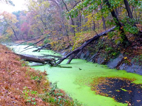
By the time I reached Widewater, the drizzle had changed to rain. Nothing I couldn’t deal with the next seven miles to Pennyfield Lock 22. Though Widewater looks like a lake, it is actually the ancient remains of the Potomac River. Other than Great Falls, the towpath along Widewater was my favorite part of this segment, as it edged along boulders and even among pine trees.
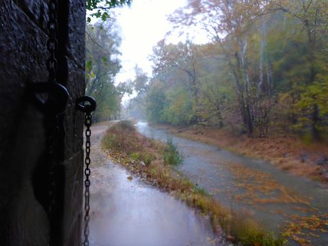
By the time I reached Lock 15 (MP 13.6) at the north end of Widewater, the skies were pouring buckets. Lockhouse 16 (MP 13.7) is boarded up, so I was relieved to find shelter under the Stop Gate at MP 13.8. I stayed under Stop Gate for about 15 minutes, until the rain sufficiently relented that I could continue my hike without washing down to Washington, D.C.
Normally, the C&O Canal towpath drains pretty well, but I was sloshing through big puddles. By the time I reached Lock 17 (MP 14.1) I had decided to bail when I met my wife at Great Falls Tavern. (Unfortunately not serving adult beverages, nor with a warm fireplace.)
The Great Falls Overlook Trail intersection is at the upstream end of Lock 17. It’s only a ¼ mile, one way, to the overlook on Olmsted Island. I didn’t realize at the time how spectacular the Great Falls are: I was happy with the first cascade. 🤗
Despite the rain, and my decision to bail, I was still hoping to ride the Charles F. Mercer canal boat, which was supposed to depart at 11. (Though only for 60 minutes, not a three hour tour, three hour tour …)
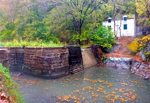
Unfortunately, the Charles F. Mercer was already in drydock for the winter, between Lock 18 (MP 14.2) and Lock 19 (MP 14.3). That’s the thing about hiking the C&O Canal: You may not see any of the hundreds of structures for a mile or two, then see a lift lock, inlet lock, dam or whatever every tenth of a mile.
Great Falls Tavern, located across a bridge at Lock 19, now houses a National Park Service visitor center. The rangers there were very friendly, and I picked up a couple of maps. Thankfully, my wife had no problem meeting me at my intended halfway point. Now, instead of handing me a fresh bottle of water, we instead skedaddled back up MD-28 and MD-85 to Frederick.
We encountered the most bizarre thing I’ve ever seen while driving, on I-70 just west of Frederick: On a Sunday afternoon at 1:00 p.m., both sides of the freeway — three eastbound lanes, and two west — were at a near standstill for several miles. I thought maybe there had been a mass accident. Then I thought “climate protesters”, but the road was not actually blocked. I wondered if Pokemon Go was still a thing because there were vehicles on both shoulders, and in the median, with people milling aimlessly about. Check out Phoenix Asshole Drivers #60 – Maryland! 🦀.
Carderock Rec Area Directions: From I-495, take exit 41, west onto Clara Barton Parkway. In 0.6 miles, exit right. At the end of the exit, turn left, crossing over Clara Barton Parkway, onto Carderock Rd. After crossing over the C&O Canal, take the first right, then first left into the parking lot. There is no fee.
Great Falls Directions: From I-495, take exit 41, west onto Clara Barton Parkway. In 1.5 miles, slant left onto Macarthur Boulevard. (Yes, the “a” in “arthur” is lowercase.) In 2.2 miles, stay left on Macarthur Blvd. In another 1.2 miles is a gated entrance. Current fees are $15 per vehicle, or $7 for bicycles & pedestrians. Parking is on the right of the traffic circle. A generally less traffic strewn option, from Hagerstown or Frederick, is to take MD-85, MD-28 and MD-190 to Great Falls.
GPS File: CO_Canal_MP11to20_Carderock_to_Pennyfield
Distance: 5.39 mi.
AEG: 168 ft.
Time: 1h 58m
Hiking Video
Hiking C&O Canal: Carderock to Great Falls from Preston McMurry on Vimeo.