

After I hiked the C&O Canal Path from Antietam Aqueduct to Snyder’s Landing last year, I began planning my Halloween 2019 hike along the canal.
In doing so, it occured to me that unlike the Appalachian Trail, or even the Arizona Trail, the C&O Canal Path was for me a doable thru-hike. I could hike the entire 184 miles from Georgetown, in Washington D.C., to Cumberland, in western Maryland, in three weeks.
But hiking is what I do to stay healthy: My real hobby is making videos. And a C&O Canal Path thru hike would either leave me with no time to produce & upload a nightly segment video, or it would result in a MOUNTAIN of work upon my return to Arizona. 😓
Instead, I broke the entire C&O Canal Path down into day-hike sized chunks of 8-12 miles, of which I will do one or two, twice a year over Easter and Halloween, through Easter, 2025. It’s my next big project after my biannual survey hikes of construction progress on Phoenix’s Loop 202 South Mountain Freeway.
Today’s hike on the C&O Canal Path would extend from mile post 0, in Georgetown, to mile 10.5, at Carderock Recreation Area.
I didn’t realize C&O Canal mile 0 is at the Thompson Boat Center, just south of the Rock Creek Park trailhead, so instead I started hiking north along Rock Creek Parkway to where the towpath actually begins.
The C&O Canal Path is wide, with a surface that is usually hardpack sand, occasionally paved (for instance under the Key Bridge). Because the towpath gets so much traffic, particularly in the D.C. Metro area, there are frequent ruts & dips in the otherwise flat surface. After a rain — especially the 2″ Maryland got last night! — those ruts & dips will be muddy or filled with water. Just like walking a canal in Phoenix.
There’s lots of traffic on the C&O Canal Path, more tourists and joggers in Georgetown, tending towards bicyclists further out. Dog walkers too. I should have lived my young professional life in Washington D.C.: There’s eye candy for everyone! 😍
There’s so many historical markers along the C&O Canal Path that I did not have time to read them all. The first one is a brass plate set in a boulder at the beginning of the towpath. The rest are mostly plastic-covered information signs with diagrams and old photos of canal life.
There’s so many interesting things along the C&O Canal Path’s first ten miles that despite my best intentions I shot 119 photos and 94 video segments. Check out the resulting hike video, below! 📽
The Locks 1 to 4 are located on the first ¼ mile of the towpath, between Rock Creek Parkway and Wisconsin Avenue, in the shadowy canyon between Civil War era factories & warehouses, converted to lofts, tech businesses & restaurants. There’s an insignificant detour around Lock 3 and Lock 4 which are fenced off for restoration work. The memorial to Supreme Court Justice William O. Douglas — who led efforts to prevent turning the C&O Canal into a roadway — is currently behind the fence.
Just before the C&O Canal Path crosses under the Key Bridge, at (milepost) MP 1, on the north side of the canal, in a small park, is the Francis Scott Key Memorial. You might be familiar with his work. 🇺🇸
The only graffiti I saw all day was 100 yds. between the Key Bridge and the Potomac Boat Club. (Rowing is very popular along the Potomac River in Washington D.C.) Adjacent to the Potomac Boat Club, there is a small trailhead at the terminus of the Capital Crescent Trail. (The Capital Crescent Trail is a paved trail which parallels the C&O Canal Path for 3.3 miles, until it crosses over the Arizona Avenue Bridge, heading north to Silver Spring.) There’s a number of crossovers, so you could easily head out on one, then back on the other.
There’s audible heavy flow in the C&O Canal in Georgetown, but the flow is normally placid west of Lock 4. Instead of the soothing sound of flowing water, I was accompanied by the cacophony of traffic along Canal Rd. NW and Clara Barton Parkway all the way to I-495 at MP 9.5. The towpath is definitely quieter in Washington County.
At MP 2.3, there is a information sign for the Incline Plane, which basically was an ‘escalator’ for canal boats to easily switch between the C&O Canal and the Potomac River. I couldn’t see any remains of the Incline Plane, which was destroyed by a flood in 1889.
The Abner Cloud House & Mill (c. 1801) and Fletchers Cove are located at MP 3.1. There’s clean, flush toilets, picnic tables, grills, watercraft & bicycle rentals, a bait shop / snack bar, water fountain, and lots of parking. I took an ice cream break. 🍦
To minimize my luggage, the only gear I typically carry with me on a fly away hike are my GPS, my pocket camera and a bottle of water. I had intended to bring some Off!, but forgot the bug juice in Hagerstown. Luckily, despite the rain, and abundant vegetation, there were few gnats and absolutely zero mosquitoes. ![]()
It was a beautiful day. Perfect.

I crossed over Arizona Avenue Bridge at MP 3.7 to check out what I expected to be a historic church. Instead, all I found was a normal well-to-do D.C. Metro area suburb. That diversion accounted for most of my AEG.
The Chain Bridge (MP 4.4) is the last pedestrian crossing to the south bank of the Potomac River for the next thirty-one miles to Whites Ferry.
I had intended to check out the abandoned Washington Aqueduct Pumping Station, just below Little Falls at MP 4.6, but the path down to the Potomac River was muddy, brush choked and rubble strewn. If I’d been on a shorter hike, with my hiking gear, I would have whacked the bush, but decided instead to return to the C&O Canal Path. Unless the pump station is your objective, you’ll want to skip it. ✋
Brookmont Lock 5 (MP 5.0) has an adjacent guard lock. Also known as an “inlet lock”, it was designed to maintain flow in the C&O Canal. Brookmont Lock 5 has a small parking area, a couple of porta potties, a water fountain and a bench. It’s a good place to turn around if you are hiking from Georgetown and don’t have a shuttle driver waiting at Carderock Recreation Area like I did.
The C&O Canal got narrower, with more fallen brush, above Brookmont Lock 5. There were lots of turtles sunning themselves on the logs. 🐢
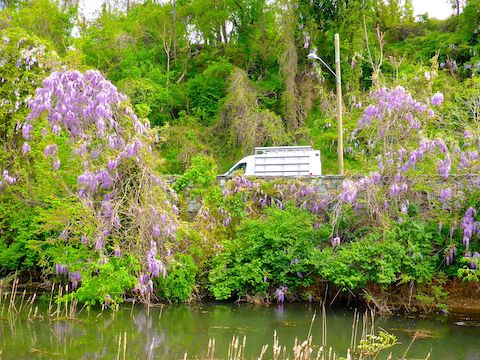
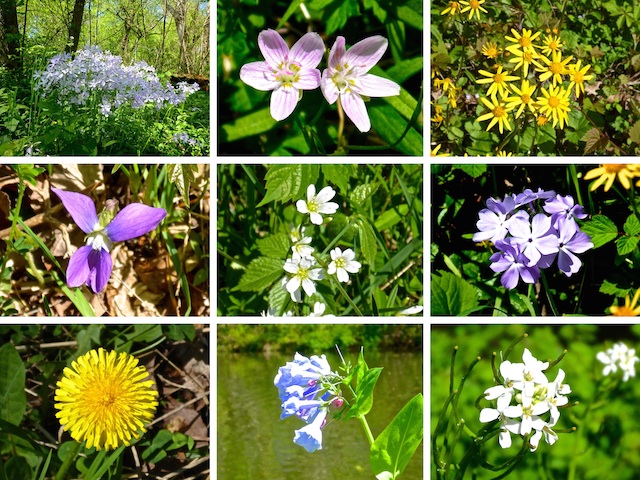
Due to the late Easter this year — I hiked in snow last year! — there were lots of flowers along the C&O Canal Path. But the most impressive flowers were not down low, but up high, amongst the trees: Endless thick clusters of pink & purple blooms. Despite all the flowers, unlike Arizona, no allergies!
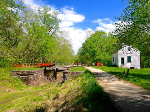
Magazine Lock 6 (MP 5.4) has the first lockhouse on the C&O Canal. Lockhouse 6 is one of six lockhouses which can be rented for $110-160 / night from the National Park Service under their Canal Quarters program. Before they became rustic hotels, the lockhouses served as the home & office for each lock’s operator.
The dam at Little Falls (MP 5.8) was the original start point of the C&O Canal. It looked like a still active facility, and there were warning signs about dangerous undertow. 🚫🚣🏻♂️
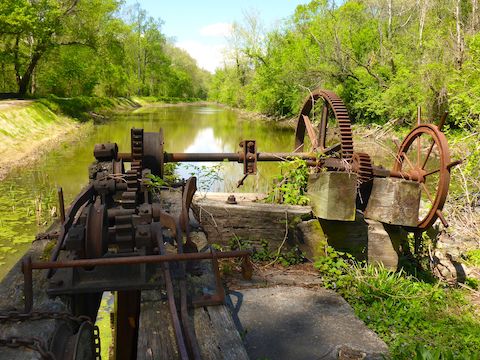
I took my second break at Chataqua Lock 7 (MP 7.0). Though not for rent, Lockhouse 7 is one of 26 still standing lockhouses on the C&O Canal. Chataqua Lock 7 was the first lock where there were well preserved gears I could get a close up look at, and even turn an inch or two.
My first C&O Canal Path hike, from Maryland Heights to Antietam Aqueduct was not this long, but there was just so much interesting stuff in the towpaths first few miles! 📝
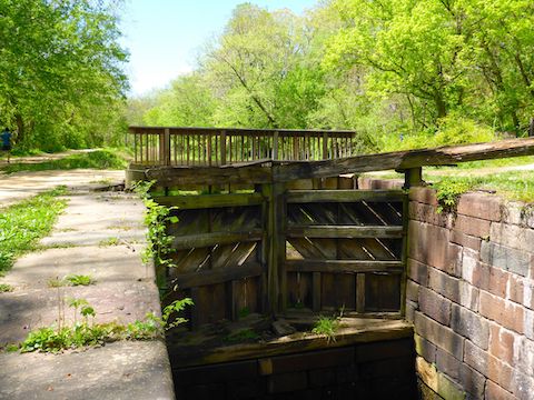
Lock 8 (MP 8.4) is the first of the Seven Locks, which raise the C&O Canal fifty feet in just over a mile to Lock 14 on the west side of I-495. Fifty is not even noticeable elevation change when you are hiking, but fifty feet is a lot for moving water. Thus, the Seven Locks. There is a picnic table in front of Lockhouse 8.
Lockhouse 10 (MP 8.8) is the second lockhouse the NPS rents out overnight. The C&O Canal Path diverts to the north bank for a ¼ mile, to Lockhouse 11, due to restoration of Rock Run Culvert, which flows under the canal. Lock 10 has a picnic table, water fountain, and parking area.
Lock 12 under I-495 to Lock 14 (MP 9.3 to 9.5) are now basically dry locks. There might be some pooling, but the only flow is that of the constant traffic on the Capital Beltway.
The Billy Goat Trail (MP 10.0) splits to left. That can be taken to the Carderock parking area, but I stayed on the C&O Canal Path for another half mile where there is a dirt towpath access road for maintenance vehicles that is the most direct route to the Carderock Recreation Area, which has picnic tables, grills, restrooms, water fountain, and lots of parking.

Georgetown Directions: From I-495, take exit 43, onto George Washington Memorial Parkway. In 8.2 miles, exit right onto Key Bridge. In 0.4 miles, turn right onto M St. In 0.5 miles, turn right onto 30th St. In 0.2 miles, turn left onto K St. Stay right onto Rock Creek Parkway. Take the first right, onto Virginia Ave., then a quick right into the Rock Creek Trailhead. There’s a pay station. Not sure about the fee, because my wife was just dropping me off.
Carderock Rec Area Directions: From I-495, take exit 41, west onto Clara Barton Parkway. In 0.6 miles, exit right. At the end of the exit, turn left, crossing over Clara Barton Parkway, onto Carderock Rd. After crossing over the C&O Canal, take the first right, then first left into the parking lot. Note: If you exit east onto Clara Barton Parkway, there are intermediate trailheads every half mile or so back to the DC border.
GPS File: CO_Canal_MP0to11_Georgetown_to_Carderock
Distance: 12.63 mi.
AEG: 374 ft.
Time: 4h 10m
Hiking Video
Hiking C&O Canal: Georgetown to Carderock from Preston McMurry on Vimeo.