

I had planned to hike Black Canyon Trail segment #9, from Bumble Bee to Government Spring, and segment #10 on to the ghost town of Cordes, last week. At this time of year, the BCT segments north of Black Canyon City are awash in spring flowers.
But things happen, and instead I hiked Pass Mountain Trail #282. Pass Mountain’s #flowerporn was disappointingly Rated G. So, this week I headed north on I-17 expecting to see the flowers I missed last week.
There’s a camping area on the west side of Crown King Rd., just south of the Welcome to Bumble Bee sign. Whether you are thru-hiking, bikepacking, camping or just driving by, you have to check out the welcome sign: It’s a hoot! 😆
The last time I hiked from Bumble Bee to Government Spring, seven years ago, I had a topo, but no GPS. Just past the mine claim gate, I went left when I shoulda taken a right toin at Albuquerque. I mean, split right. I ended up a gulch, unsure exactly where I was. I eventually managed to get myself back on the Black Canyon Trail.
This time, armed with my crappy Garmin 62S, I split right. Once you clear Bumble Bee, there never is any question which way the Black Canyon Trail is going. The BCT crosses a jeep trail every mile or so, but the crossing is always signed on both sides. Plus, the difference between the wide jeep trails and the single track BCT is quite obvious. (Unless you are n00b like I was.)
Despite being single track, the Black Canyon Trail is smooth, and only rarely rocky. That’s why Aravaipa Running hosts a 100k ultramarathon, south from Spring Valley to Emery Henderson Trailhead, on the BCT every February. South is generally downhill, while north — the direction I was heading — is generally uphill. It was Aravaipa Running who had all the signs and tents out when I hiked Estrella Mountain Regional Park two months ago.
The BCT was damp from light rain last night. Temperatures have also been increasing. So, once the sun was fully up, illuminating the various washes and spurs, I was hoping to enjoy some quality flora.
The first color I saw was an orange Aravaipa Running trail ribbon.
A little over two miles in, just after crossing Mexican Gulch, I spotted an apparently abandoned mining camp on the slope of Bland Mountain. It looked like a wooden shack had been built around a large metal tank. I’ve never seen that before. It went on my list for future mine exploring.
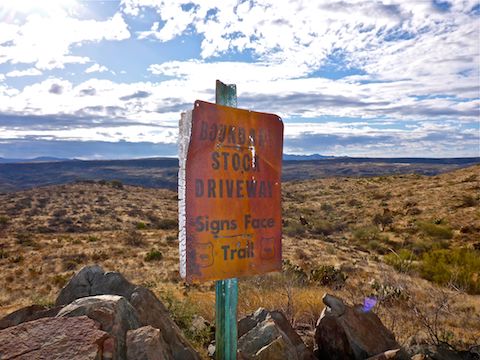
A few minutes later, just off trail, I noticed a metal sign propped up by rocks. I thought it might be a claim, but instead it was a Forest Service “Boundary: Stock Driveway: Signs Face Trail” sign. No clue what that means, as I saw no trail other than the Black Canyon Trail single track.
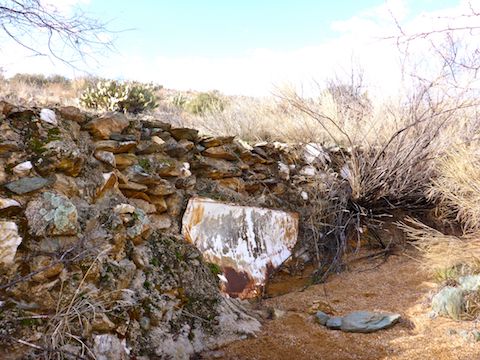
Four miles north of Bumble Bee, I turned up a wash to do a wee bit of mine exploring. The topo indicated a vertical shaft, but I did not find it, nor any evidence of past human presence other than a man made retaining wall paralleling the wash. Near the end of the wall, there was a thin metal plate across the wall. I could not pull it out, or peer past it. I wonder if it was covering an adit?
Crown King Rd. is never more than three quarters of a mile from the Black Canyon Trail. It’s dirt is often visible between Bumble Bee and Government Spring. I-17, the Black Canyon Freeway, up on Black Mesa, is three miles away, but thankfully no traffic sound filters down to the BCT. If you see antennas up on Black Mesa, that is the rest stop at Sunset Point. There are near daily traffic-caused brush fires at Sunset Point and indeed one started about an hour after I finished my hike. (And at the same time the next day.) 🙄
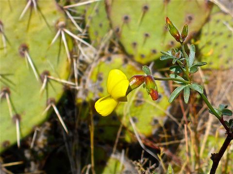
Finally, two thirds of the way into my hike, I spotted a flower, a yellow wiry lotus. And … that was it. One fricking flower all damn day long.
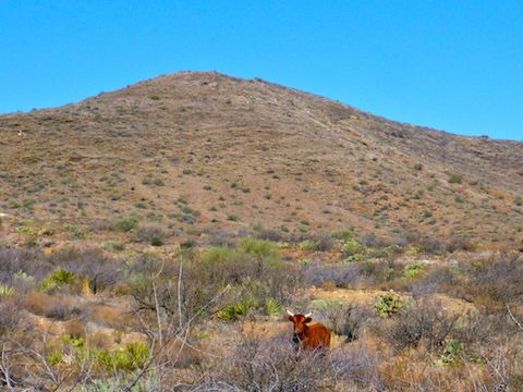
The final two miles to the Government Spring oasis & corral was basically flat, through scant brush that at first glance appeared burnt but was actually just stabby. No hope of flowers, despite ample fertilization by the cattle I “wrangled”.
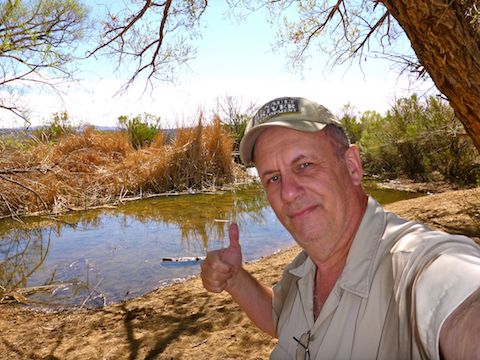
The Black Canyon Trail crosses Crown King Rd. at Hidden Treasure Mine, where Yavapai County 179 splits northeast up to the ghost town of Cordes, then to I-17 at Bloody Basin Rd. There is a large, dry, metal tank at the north end of the trailhead, and a corral at the south end. The corral had a full spring box (though Government Spring is actually a mile southeast), with a fair amount of algae, but the horses didn’t mind. There is a pond adjacent to the corral. I call it that, rather than a cattle tank, as it has reeds and other pond-like vegetation. Towering over the pond & corral was a massive mesquite, making the whole area a shady, peaceful, oasis.
Due to the lack of flowers, I called it quits at the oasis, rather than continue on Black Canyon Trail segment #10 to Cordes. Not only did I avoid the subsequent Sunset Point brush fire, but my wife & I had time to stop at historical Rock Springs Cafe for lunch and a slice of their best-in-Arizona pie. 🤗🥧
Directions: From I-17 at the Loop 101 in Phoenix, head north on I-17 for 33 miles to Crown King Rd., Exit 248. Pass under both segments of I-17, taking care not to get back on I-17 southbound or, worse, against the flow of southbound traffic. (Easy to do if you are not paying attention.) The road is very twisty. In a mile, on the left, will be the Crown King Rd. trailhead. The road soon turns to dirt. Two miles from I-17, merge north on Crown King Rd. Five miles from I-17, you will cross a narrow bridge over Bumble Bee Creek. Park in the best spot you find after crossing the bridge.
GPS File: BCT_9_Bumble_Bee_to_Government_Spring
Distance: 7.65 mi.
AEG: 819 ft.
Time: 2h 51m
Hiking Video
Black Canyon Trail: Bumble Bee to Government Spring from Preston McMurry on Vimeo.
The oasis is a lovely and delightful rest stop. I wouldn’t mind going there again.