

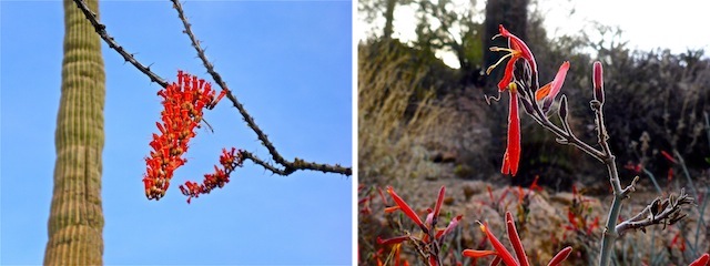
I planned to hike Black Canyon Trail today, as the segments north of Rock Springs Cafe are an underrated source of beautiful spring flowers, in quantity, quality and variety: Chuparosa, lupine, fairy duster, wiry lotus, blue dick, buckhorn cholla, and more!
Thursday at noon, my shuttle hike fell through. Not wishing to do an 22 mile out & back, I had to scramble for an alternative.
I wanted something with flowers, as our late monsoon finally brought a bit of rain. With rising temperatures, I figured Phoenix-area trails would be popping with color. But I didn’t want to do something I’ve done in the past year, particularly if I’d already done a hiking video on it, like Palo Verde Trail #512 at Bartlett Lake. 🤔
Hiking Pass Mountain Trail #282 in Usery Mountain Regional Park is what I came up with.
I’ll do Black Canyon Trail from Bumble Bee to Cordes next week. Hopefully.
I left home at 5:30 a.m. to beat rush hour traffic. AZ-51 southbound and Loop 202 eastbound to the 101 are both heavy traffic even at that hour, but doing 30 mph on the connector ramp is just nuts when the flow of traffic 65+. Phoenix Asshole Drivers! 😖
I stopped for breakfast at the Falcon Field Waffle House on McKellips Rd. in Mesa. I dawdled over my Hashbrown Bowl, then again over Twitter at the Wave Cave Trailhead in Usery Mountain Regional Park, until it was light enough to take half decent photos. I started hiking at 7:30 a.m.
From the toilet building — they flush! — it is only 25 yds. to the first intersection. Turn left to hike Pass Mountain Trail #282 clockwise, right to hike it counterclockwise. Either way is 7.5 miles, 900 AEG, though clockwise is a more gradual climb. Straight ahead, on a steep twisty trail, is Wind Cave Trail #281. Hiking that option will add 3.0 miles (round trip) and 800 AEG to your day. Usery Mountain Regional Park has many other less strenuous options south of Pass Mountain.
I turned left.
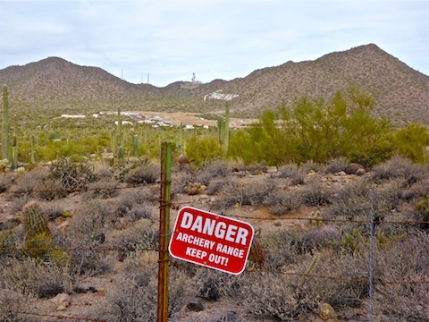
Eight years ago, as Pass Mountain Trail #282 squeezed between the archery range and the mountain’s lower slopes, it was often deeply eroded. Now, it is pristine. Wide & smooth. Even the cholla don’t seem as bad. There are several memorial benches for older folks to rest on. There’s also a lot of saguaro, more than anywhere else in the park. Many of the saguaro are quite spectacular, including one specimen that I swear had two dozen arms on it.
At 1.8 miles, is the Maricopa Trail intersection. It is 1.4 miles northwest to the Bulldog Trailhead. If you use Bulldog, are cheap and want to avoid the Usery Mountain Regional Park’s $6 entry fee, beware that you instead need to purchase a Tonto National Forest daily pass, which is $8. Don’t be cheap: Support our parks & forests. 🏞💵
After the Maricopa Trail intersection, the sound of gunfire from the range on Usery Pass Rd. fades.
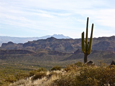
A quarter mile later, on Pass Mountain’s north slope, is an unsigned turnoff to the Viewpoint. (It is indicated on the park map handed out free at the entrance.) The Viewpoint has fantastic 240° views: Southwest, across Mesa, to the Sierra Estrella 40 miles away; 13 miles northwest, across Fountain Hills, to the McDowell Mountains; 21 miles northeast to Four Peaks; and just a few miles east to the Goldfield Mountains. That small mountain, all by itself a mile north, is the appropriately named Lone Mountain.
After enjoying the Viewpoint, casual city hikers should turn back.
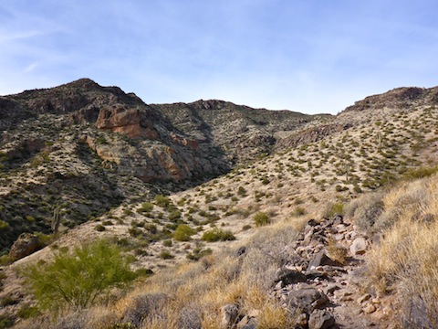
The 1.9 miles between the Viewpoint and the Saddle are still good trail, but not the highway the previous two miles were. It is narrower, with a few eroded sections, and some small boulders to be negotiated, but nothing risky. The vegetation changes from cacti to grassy slopes. There’s good shade where the trail crosses Pass Mountain’s east slope washes. Like I said eight years ago, it is my favorite part of Pass Mountain Trail #282 as it is the furthest from civilization and the least travelled. (Unfortunately, the one guy I encountered was talking, loudly, on his mobile.)
The saddle is halfway around Pass Mountain Trail #282. There’s an open area that would make a good group rest stop. There’s also a geocache. I had the geocache marked on my GPS, but was so engrossed in picture taking, I forgot to look for it. (I have it marked on the route I attached below.) Scrambling to the top of the knob that overlooks the saddle is only another 30 ft. Apache Junction looks much nicer from the saddle. 😎
The switchbacked descent south off the saddle is steep, and much rockier, with 1-3″ ankle breakers, and at least one very eroded area that I had to be careful crossing. Definitely no walking video there!
From the Saddle 1.7 miles down to Meridian Rd. there was heavy hiking traffic headed up to the saddle. West from Meridian Rd., a mile to Cat Peaks, paralleled a housing area, but at least the footing improved. If you want some extra mileage, there’s a 1.5 mile, 150 AEG, loop around Cat Peaks. (And numerous flat as a board trails off that.) Cat Peaks are a misnomer, as none of the “peaks” is more than 200 ft. high. 🙄
The Pass Mountain Trailhead is a half mile west of Cat Peaks. At the Pass Mountain Trailhead, I turned north for a bit over a half mile back to where I started at Wind Cave Trailhead. Pass Mountain Trailhead is a horse lot, but there might be some parking there if the Wind Cave Trailhead is full (as it was when I returned).
I had thought about adding the climb up to Wind Cave, but decided to skip it, opting instead to rehydrate at a picnic table and catch up on Twitter, then head home early to begin work on the hiking video.
Directions: From Loop 202 / Red Mountain Freeway in Mesa, take exit 24. Head east on McKellips Rd. for 2.2 miles. Turn left onto Ellsworth Rd. / Usery Pass Rd. In 2.2 miles, turn right onto Usery Park Rd. The Usery Mountain Regional Park entry fee is $6. In 1.5 miles, turn left onto Wind Cave Dr., parking at any of several lots on the one way loop road.
GPS File: Pass_Mountain_Trail_282
Distance: 8.21 mi.
AEG: 977 ft.
Time: 2h 58m
Hiking Video
Hiking Pass Mountain Trail #282 from Preston McMurry on Vimeo.
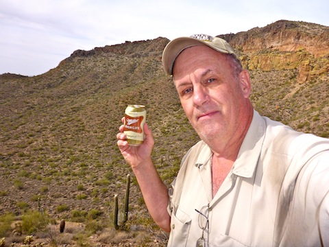
Good old Miller beer. Nice choice.