

I was planning to hike the Black Canyon Trail this week, as it has a wide variety of spring #flowerporn. But our winter monsoon has been late, and light, and temps have been very low the past week. (-12 at the Grand Canyon!) Due to the weather, I figured flowers would be few & far between. I’ll give it a couple of more weeks.
Not willing to repeat last week’s one — ONE! — flower performance on Lake Pleasant’s Beardsley Trail, I began casting about for something interesting to do at an elevation likely to exceed 50℉.
I haven’t been to the Harcuvar Mountains in two years, since I explored Webber Mine. While considering the possibility of climbing the Harcuvar’s high point Smith Peak, I noticed some mining symbols on the topo, on some small volcanic hills near the range’s east end, just off Smith Peak Road. On sat view, the road looked decent, so I began my planning.
Bullard Mine and Sandy Mine are on Bullard Peak, which is the grandiose name given to the small volcanic hill — prominence ~500 ft. — I had noticed. On sat view, I could see the remains of several structures, numerous winding mining roads, equipment and many possible adits and shafts. (The shadows cast in an adit or shaft are different than the shadows cast by desert vegetation, like cacti and palo verde.) I mapped out a route that would take in all the visible cool stuff, and was about 7.5 miles. And, if I had time, I would ‘summit’ Bullard Peak.
Smith Peak road was okay, but gravelly and very washboarded. It improved 9.9 miles from Aguila, after reaching the base of the Bullard Peak loop road at the wilderness sign. (The info is on the north side, away from the sun; direction of travel side is blank.) At the Smith Peak Road warning sign (12.3 miles), I turned east on the Bullard Peak loop road. It got a lot rougher. Because the sun was low, and straight in my eye over Bullard Peak summit, I missed the turn off to the corral and had to double back. The corral is a good trailhead: Easy to spot from the air, in case you get stranded, and out of sight of any vehicles on the loop road.
The corral hasn’t been active in a long time, and the large cement tank is bone dry. No sign of a windmill to pump water into it. Next to the tank is a large pile of overburden, in the middle of which is inclined shaft. It did not appear to be deep. I wonder if it is the inclined shaft I saw mentioned in Sandy Mine’s documentation: 40 ft. deep shaft, inclined 45°, with ladder in good condition (in the 1940s), to exposed, but undeveloped, vein? I did not go down.
There is another shaft, on the other side of the corral, but I could not find it. My wife found it while I was gone. It was more like a tunnel, but heavily collapsed. I would not have gone in that either. Both of the corral shafts are on the topo.
200 yds. northeast of the corral, there is an exposed rock face with copper mineralization and multiple drill holes. Obviously some of the test drilling conducted between 1957 and 1990 was done here. (Both Bullard Mine and Sandy Mine were no longer operational after 1956.) The eight mining companies who did the drilling must not have found economically recoverable ore bodies. In it’s heyday, Bullard Mine produced 614,000 pounds of copper, 3300 ounces of gold and 5900 ounces of silver. That is $6.5 million at current market prices. 💰
There are old miners’ trails all over Bullard Peak. Throughout the day, I alternated between cross country travel, the loop road and miners’ trails. After the drill holes, I began working my way across Bullard Peak’s lower north slope. I was on the lookout for anything interesting that I had not scouted on sat view. Halfway up the summit, I spotted a small pile of overburden, indicating the presence of some sort of mining activity.
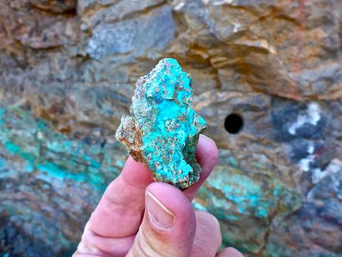
I climbed up, finding an adit that was not on the topo. Outside the adit, there were some nice samples of chrysacolla. Inside, the tunnel only went 50 ft. before dead ending at a pack rat nest. Oh well. It was still fun finding something by accident. 🙂
From the unknown adit, I headed down a small wash, hoping to find some treasures that had flowed downhill. No such luck.
I was finally starting to generate some body heat. Important, as it was 31° — in the sun — and windy when I started at 8:30 a.m.
Then I checked out rain apron / catchment area. It was a typical example: A gated tube metal fence, inside of which is a wedge-shaped, slightly-inclined, concrete pad, at the narrow end of which is a drain that feeds to a cement box. The concrete pad creates a larger water-gathering area. The box is often covered, to reduce evaporation. The water is for desert game, like deer and javelina, in otherwise waterless terrain. 🏜
After the rain apron, I dropped into another wash, to check out a well. I thought the well would be windmill-powered, feeding to a cattle tank, as they typically do in Arizona. Instead, it was an actually pit well, maybe 20 ft. deep to water level, with a brick wall and metal bucket bar. The water smelled awful. I wonder if something fell in & died?
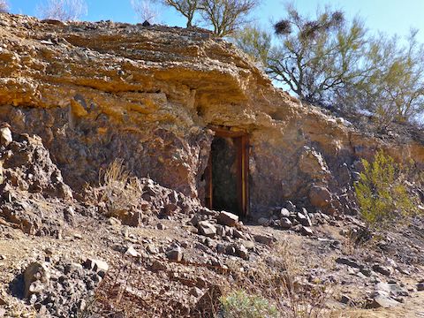
Just down wash I found one of the coolest things I’ve ever found in my short mine exploring career: A miners’ cabin dug into the wash wall. Outside was a rusty bed spring. The doorway had a square wood frame, with rusty hinges. (The door was missing.) At the end of a short passageway was a small alcove, in the wall, above which was a stove vent, surrounded by some soot. That’s when I realized it was a ‘cabin’, not an explosive locker. (Because heat & explosives don’t play well together.) To the right, in a larger alcove, was a bed-size wood rack. To the left, in another alcove, was another wood rack, as if for storage. I’m surprised the miner never got flooded out, as the entrance was only elelvated maybe a foot or two from the wash bottom. Sweet find!
Then it was up a steep & rocky mining road to Bullard Mine proper.
First up was what the topo indicated was a “shaft”, but looked more like a near surface stope. Outside was the remains of a collapsed headframe and what looked like a small, ad hoc, kiln. The wind was frigid. I could have used the shelter afforded by the shaft, but it looked sketchy, so I didn’t go in. ✋
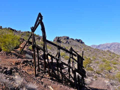
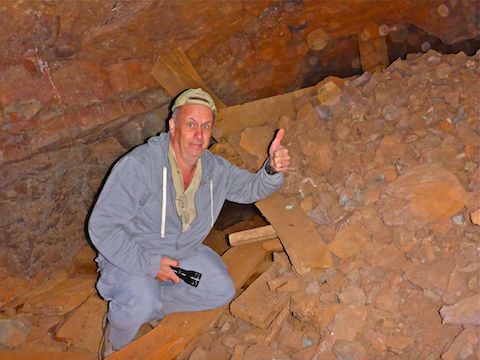
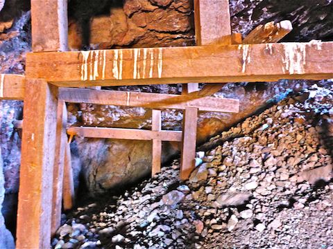
A little further upslope was a fairly intact headframe. I had actually seen it’s shadow on sat view, but seeing it on the ground was the other highlight of my Bullard Mine exploration. Behind the headframe was an adit — I’ll call it Adit #1 — that looked more like an inclined shaft. The rock surrounding Adit #1 was bedrock, with zero collapse, so in I went.
My flashlight was strong enough to see, but was crap for taking video. Again. I really need a flashight that has a wide, bright but diffused (not too bright), middle-distance beem, and that does not weight a ton. So I shot some video, and took some pictures. In my mine exploration video, below, as a compromise, I frequently spliced the audio from video segments over flash photo stills.
The ceiling of Adit #1 looked solid, but there was a fair amount of collapse and timbers on the ground. To the left was a sketchy stope I did not enter. Ahead, was a passage I could have entered, but also avoided. Don’t recall why. Maybe the Budweiser can warned me off? Instead, I checked out a passage to the right. Inside was a large amount of gobbing. The passage continued, but there was more collapse, so I headed out. No artifacts, unless you count a Budweiser can of relatively recent vintage. 🙄
Finally, yet a bit further upslope, was a third headframe, also in ruins. Behind it was Adit #2, which had two entrances, one another near surface stope, the other a more traditional roundish hole in the ground.
Adit #2 had the heaviest timbering of all. It also had the most collapse, but most of it was from the inside of the near surface stope, through which I could see plenty of sunlight. I worked my way past the collapse, exploring deeper. There was some pretty blue copper mineralization — though nothing will ever beat Copper Creek — and one vein that was whale-shaped. But no artifacts, and the two branches both quickly dead-ended. (I thought Adit #2 might go through the mountain, as the topo has another adit symbol, at a similar elevation, on the west side of the Bullard Peak ridge.)
It was already 1:00 p.m., and I had only covered 1/3 of Bullard Peak, and only half of Bullard Mine, so I decided to save the rest for future mine explorations and call it a day. ⏰
Directions: From Wickenburg, head west on US-60 for 36 miles to Aguila. Turn right (north) on Eagle Eye Rd. After 2.0 miles, it turns to car-drivable dirt. In 4.0 miles, turn left (west) on Aguila Valley Rd. In 3.0 miles, immediately after crossing the wash, split right onto Smith Peak Road. You might make it in a car, but it is gravelly and washboarded. Head northwest towards a low cluster of volcanic hills. Park at the base of the largest volcanic hill between 3.7 – 5.2 miles. Turning off Smith Peak Road to the corral requires an SUV or better.
GPS File: After I finish exploring Bullard Peak. 😉
Distance: 6.03 mi.
AEG: 982 ft.
Time: 3h 03m
Mine Exploration Video
Exploring Bullard Mine, Harcuvar Mountains, AZ from Preston McMurry on Vimeo.
Beautiful rocks!
As if I could take credit. ;-p