

So far, in 2018, I’ve been alternating hikes on local trails and those further afield. (And they don’t get much further afield than Tunnel Mine Canyon & Skull Rock.) The object being to document Phoenix-area trails for those who don’t have the time to get out of the Valley of the Sun, or who prefer not to freeze at higher altitude — though freezing days have been as rare as snow this winter — or who are seasonal visitors from places that actually have been cold this winter, such as Wisconsin.
It was overcast, windy and a chilly 55° when I arrived at the Agua Fria Trailhead, just north of the Carefree Highway (AZ-74), at the south end of Lake Pleasant. I’ve driven past the Beardsley CSR Road, many times. I always thought it was “official use only”, but at least as far as the trailhead, it is open to the public.
Even though Lake Pleasant is less than 30 minutes from my home in Sunnyslope, I left early to avoid the beginning of rush hour. After dodging a few Phoenix Asshole Drivers, I arrived at the Agua Fria Trailhead while it was still dark. I caught up on Twitter while I ate breakfast and drank coffee.
The sun rose, but it still wasn’t sunny due to the overcast. I was bummed because I had hoped the clouds would result in a spectacular Arizona sunrise. It was 7:20 a.m., so I started hiking.
The first of six gates, a ‘V gate’, is at the trailhead. (The rest are all some variety of swinging gate.) After passing through the gate, Beardsley Trail descends to Morgan Wash on the Agua Fria River. Morgan Wash is filled with typical Arizona river bottom brush, but there is no threat of impromptu acupuncture, as Beardsley Trail is well cleared. That remains true all the way to Wild Burro Campground. The temperature is noticeably cooler in Morgan Wash, which is crossed by two wooden footbridges. (With a second gate in between.) On the west side of Morgan Wash, the Maricopa Trail — which is initially co-located with the Beardsley Trail — turns south while Beardsley turns north.
After Morgan Wash, Beardsley Trail crosses the third gate, travels north on the siding of Old Lake Pleasand Rd. for 250 yds., then passes through the fourth gate on the west side of the road.
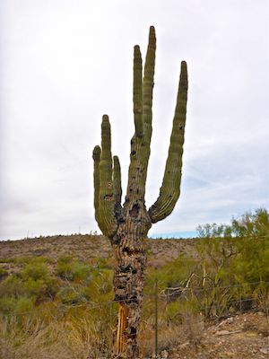
After 0.7 miles, it had become obvious there would be neither spectacular scenery, nor flowers, along Beardsley Trail. (Too soon after our only rain, so far, of Arizona’s winter monsoon.) If my hike video had been a slideshow, it would have been 15 seconds long. Thankfully, I was shooting plenty of video, while occasionally taking saguaro pictures, like I had at Skyline Regional Park.
After crossing Old Lake Pleasant Rd., Beardsley Trail is never more than a ¼ mile from pavement. The sound of heavy Carefree Highway traffic begins fading, being replaced by regular aircraft flybys, particularly a plane that looked similar to a Beechcraft Model 18, but with a single tail. It was overhead, off & on, for four hours. Does someone do air tours over Lake Pleasant like they do the Grand Canyon?
Beardsley Trail generally follows the contour line from spurs & washes running west off Lake Pleasant. Heading north, it is uphill (550 AEG), with two 170 ft. climbs. Heading back south to the Agua Fria Trailhead, Beardsley is generally downhill (300 AEG). The trail surface is not pristine like Turnbuckle Trail in Skyline Regional Park, but it is still mostly rock-free. Beardsley would be awesome for trail running, or as a fast mountain bike track. Still, my inner tard emerged as I managed to stub my toe a dozen times, stumbling eight of those. 🤪
At 2.2 miles, Beardsley Trail crosses the fifth gate, then intersects Frog Tanks Trail, which runs 0.3 miles northeast to the Bobcat Day Use Area. From there, it is 2.1 miles, a sixth gate, and a final road crossing, to Beardsley’s northern terminus on Desert Tortoise Rd. I contemplated turning around, but decided since it was only another 0.4 miles to the picnic tables at the Wild Burro Campground, above Two Cows Cove, that I would continue.
At the Agua Fria Trailhead, I heard coyotes yip several times, but I wasn’t able to spot them. Or wild burros anywhere, despite plenty of burro scat scattered along Beardsley Trail. Lizards are the most common critter I see while hiking, and I don’t recall seeing any of them either. All I saw was one rabbit, and a few birds here & there.
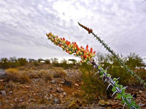
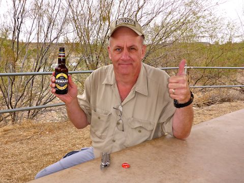
At Wild Burro Campground, I spotted the only flower I saw all day, on an ocotillo. In five miles, and three hours, I had not quite finished a bottle of water. I rehydrated with a half bottle of gatorade and a McEwan’s Scottish Ale. At 8%, I could feel the alcohol’s effect. Good thing I had five return miles to sweat it out. 🍺
On the return I drank a second water. Despite my low fluid intake, I peed an oddly large number of times, six from the time I arrived until I left. Usually it is once or twice. Any idea why that would happen?
To summarize, Beardsley Trail is good exercise on a great trail, but nothing really special without scenery, flowers or critters. But it does have far fewer people than Piestewa Peak, so there is that.
Directions: From Phoenix, head north on I-17. Take exit 223B onto Carefree Highway / AZ-74. Drive west for 9.1 miles. By Lake Pleasant, at the bottom of the hill, just after you cross the second bridge, turn right onto Beardsley CSR Rd. The Agua Fria Trailhead is 0.3 miles straight ahead, on the left.
GPS File: Beardsley_Trail_Lake_Pleasant
Distance: 10.50 mi.
AEG: 1,028 ft.
Time: 3h 39m
Hiking Video
Hiking Beardsley Trail, Lake Pleasant from Preston McMurry on Vimeo.