I’ve had this on my list for probably two years. I had planned to do Camp Bouse Peak today, but discovered the desert racers had an event this weekend, and much of their race takes place along Powerline Rd., thus blocking access to Camp Bouse Peak. I plan on doing the peak this upcoming Thursday, 1/14. If anyone is interested, let me know.
Regarding the attached routes: One is for the drive in, the other for the hike itself. The hike route is the same as the official route, but with waymarks added for the various things I found. See the drive route description for the drive conditions. You will need at least AWD and a few inches extra clearance; cars are a no go.
Not that it will be needed, but there is plenty of water — two nearly full metal boxes — at the rain apron.
Lots of burro poo, but no burros sighted.
I checked out the hill behind the rain apron for petroglyphs, but did not spot anything. The “road” gets much rougher entering the wilderness area, very similar to creek walking. It’s a steady, but not unpleasant climb, with multiple wash crossings. The views of 4,593 foot E C P Peak, and other nearby prominences, were gorgeous. If anyone ever wants to take a crack at E C P Peak, the wagon trail to Webber Mine would be the ideal start point, as it’s only another 1000 feet to that summit.
There’s not much left of the mining camp: One possible cabin / chicken coop area. (It actually looked more coop-like, and was too small for a corral.) Two metal tanks, one cylindrical, one round & flat. A cabin, with foundation. A series of mysterious wood posts, seemingly without purpose. The wood for the posts, and elsewhere in the camp, had to have been imported, as there are no trees within dozens of miles, of the thickness and length I saw. Maybe the lumber came from Prescott?
A quarter mile above the camp are the mine workings: A small adit, a shaft and a tailings pile.
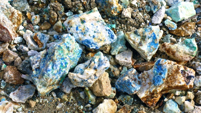
The tailings are outside the shaft, which is above the adit. So, the tailings appear to have been hauled up & out of the shaft which is at least 100 feet deep. It is fenced off, but you can look over the edge. There was some very attractive blue highlights in some of the tailings, and some green as well. Probably azurite and malachite, as Webber Mine was a Cu-Ag mine. (Last operated in 1923.) The green in the tailings was of a different quality, more metallic, than the green I ocassionally saw in trail rocks below the camp. Those trail rocks were more of an olive green. Maybe peridot?
The adit had a tight opening, due to collapse, but I knocked on the timbers, and they did not move, so in I went. There was a second collapse 10 feet in, which I cleared. Just beyond a third collapse, the tightest of all, was a small chamber. The area was a bit chalky, so rather than proceeding, I bailed. I low-crawled the whole time.
After lunch and a “summit” brew, I headed back to my patient wife at the trailhead. ![]()
GPS File: Webber Mine Drive & Hike
Distance: 7.48 mi.
AEG: 1,240 ft.
Time: 3h 8m
Drive Video
Hike Video
Exploring Webber Mine, Harcuvar Mountains from Preston McMurry on Vimeo.
