

Picked up Stephen at the Lowes on Higley & 60, then headed up Power Rd / Bush Hwy to the Beeline. Only saw one cop on Bush! While FR 143 did not have ruts, it was heavily washboarded. That’s as far as I would go in a car. FR 1343 had ruts and dips, but is not bad as long as you go slow. Our problem was the low-lying sun right in my eyes. ![]() The glare was so bad, I would not have been able to see oncoming traffic (luckily there was none), and did not see several ruts which I hit at the wrong angle and/or a bit too fast. (Despite going slow.)
The glare was so bad, I would not have been able to see oncoming traffic (luckily there was none), and did not see several ruts which I hit at the wrong angle and/or a bit too fast. (Despite going slow.) ![]() The worst dip was just west of the corral near the FR 1343 / FR 13 intersection. I crowned my SUV going down it (glare = bad angle), and on the way back (no glare) spun tires first time, before backing off, then making it up no problem second time. I combat parked just past the FR 1813 intersection on FR 13, after scouting a hundred yards ahead on foot, and deciding that was far enough. Stephen did not have a problem with an extra 5 miles (round trip) walking, so off we went.
The worst dip was just west of the corral near the FR 1343 / FR 13 intersection. I crowned my SUV going down it (glare = bad angle), and on the way back (no glare) spun tires first time, before backing off, then making it up no problem second time. I combat parked just past the FR 1813 intersection on FR 13, after scouting a hundred yards ahead on foot, and deciding that was far enough. Stephen did not have a problem with an extra 5 miles (round trip) walking, so off we went.
It was a good decision. The jeep trail gets quite rocky in spots, even more rutted, with larger drop offs, as you head south on FR 1829. I would not go past our “trailhead” without 4WD, high clearance and at least some skill — especially on the portion between the official “trailhead” and Brownie Tank.
The walk itself was a jeep trail walk, ![]() though the surrounding bluffs, canyons and mountains kept it from being too much drudgery. I had an alternate jeep trail (FR 1345) on my GPS as a possible option / for variety, but we ended up skipping it both ways.
though the surrounding bluffs, canyons and mountains kept it from being too much drudgery. I had an alternate jeep trail (FR 1345) on my GPS as a possible option / for variety, but we ended up skipping it both ways.
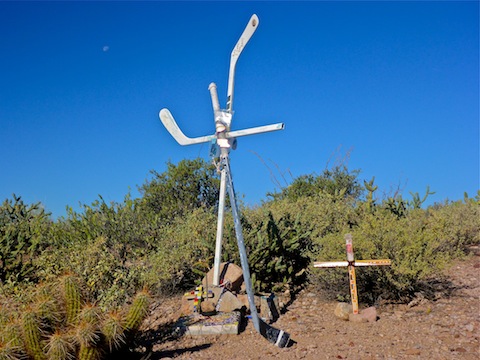
I was quite surprised to see a roadside memorial (obituary) way out there. (Stephen spotted it, as I was road staring / avoiding further knee injury, as I usually do.)
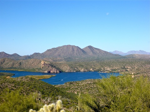
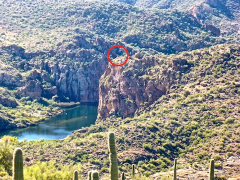
The Hill 2074 bluff is fairly brushy, but only about 250 feet, so we made it up sharpish. Despite wandering all over the hill top, and even over the far edge, we never did see the mascot. Great views, but quite disappointing nontheless, as I was under the impression it was on the bluff. Stephen thought he saw something at 33.565028 / -111.467803, but after walking the extra miles, and looking at the intervening half mile of terrain, we decided we had gone far enough. Your best bet to see the mascot is a boat, but if it is where we think it is, then the mouth of Cottonwood Creek would put you only 200 yards from the cliff, rather than 800 yards like we were, so at least within crappy camera zoom range. ![]()
The hike back was quite warm. Not only is there no shade on the hike, but the air temp felt much warmer than 81. (Indeed, back at my car, I got a reading of an even 90.) Like I told Stephen, it’s not a hike you want to do in July! ![]()
GPS File: AZNG_Mascot
Distance: 10.39 mi.
AEG: 1,291 ft.
Time: 4h 12m