

Slowly, but surely, I am working my way through the canyons on the Mogollon Rim.
At the end of May, I canyon crawled Box Canyon between General Springs Canyon and Fred Haught Canyon in the Coconino National Forest. Today, I decided to skip east twelve miles to hike Beaver Canyon, which is between Knoll Lake and Bear Lake in the Apache-Sitgreaves National Forest.
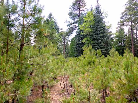
The head of Beaver Canyon is right on FR 300 / Rim Rd., ¾ of a mile east of Horton Springs Trail #292, which drops over the Mogollon Rim, descending to Horton Creek Trail #285. 🏞
I had hoped to park just off Rim Rd. on FR 92, but the forest road was blocked by a locked gate, and signed “No Motorized Vehicles!” (Pedestrians, bikes and horses are allowed on FR 92.) Not only are motor vehicles banned on FR 92, but apparently all along Turkey Beaver Ridge — that is its name — and in Beaver Canyon. There was a pull out next to FR 92, but someone was camping there and I didn’t want to intrude, particularly since my wife was staying behind. Instead I found a nice viewing spot off Rim Rd., but with a great view of the Mogollon Rim and points south. So, I parked there. (See the attached GPS route, below.)
Beaver Canyon extends 6.3 miles from Rim Rd. north to Turkey Creek. Compared to some other Mogollon Rim canyons, such as Crackerbox Canyon, it is a walk in the park. At 4.6 miles, FR 92 intersects Beaver Canyon at Turkey Crossing. Looping back to Rim Rd. on FR 92 is 5.2 miles. If you continue the extra 1.7 miles to Turkey Creek, you will either need to loop back via Turkey Creek, or bushwhack up 300 steep feet to FR 92B. Also, you could always turn around head straight back the way you came. 🧭
So, your Beaver Canyon hiking options are:
- To Turkey Crossing: 9.8 mi., 750 AEG. Shorter & climb out is on jeep trail.
- To Turkey Creek, Bushwhack Out: 12.4 mi., 1000 AEG. Long, with 300 AEG bushwhack out at halfway point.
- To Turkey Creek, Follow It Back: 13.1 mi., 1000 AEG. I have no clue what the terrain in Turkey Creek is like. 🤔
- Beaver Canyon Out & Back: 12.6 mi., 1000 AEG. Long, but mild.
I chose option #2: Hike Beaver Canyon to Turkey Creek, then bushwhack 300 AEG to FR 92B, then take FR 92 back to my SUV.
I walked east a few hundred yards on Rim Rd. I saw a jeep trail on the north side of Rim Rd., that I thought was FR 92D, but is one of many unnumbered jeep trails that are not even noted on the topo map. From the anonymous jeep trail, I soon down a steep, debris strewn slope, to Beaver Canyon. I hit the canyon bottom a ¼ mile from Rim Rd.
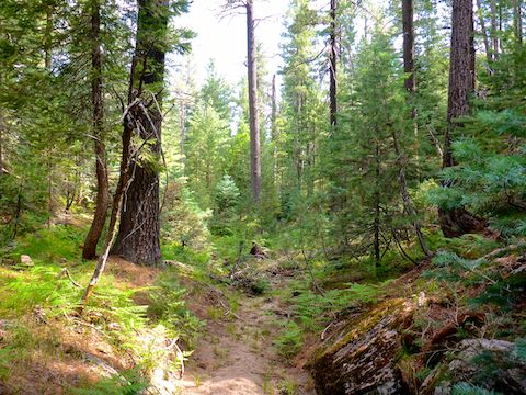
Initially, Beaver Canyon was a little congested, and tangled, but not too bad. I soon picked up a very distinct animal trail. Indeed, it looked more like trail built by humans, it was so well defined. 🛣
After a ¼ mile on the Beaver Canyon bottom, I encountered what look like a corral with a broken gate. Instead of crossing the corral, I followed the animal trail around it. The corral was 350 ft. long. In less than 100 yds., there was a second corral, which seemed to go on forever (roughly 1500 ft. long). The second corral is where it struck me that the corrals seemed intended to protect the riparian / creek area. Not that the broken down gates & half-collapsed fences were doing much good.
I didn’t notice if there was was water in the creek bed of the first two corrals, but Beaver Canyon was definitely dry everywhere else the first two miles.
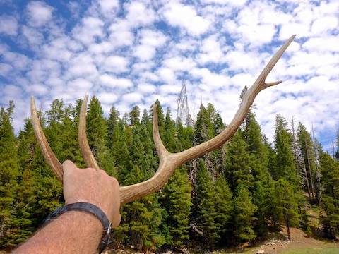
At 1.7 miles, Beaver Canyon opens up into the half mile long prairie known as Beaver Park. Hiking across prairie is actually a bit difficult, if you are not a pronghorn: Like walking on rocks in a creek bed, except tufts of grass. Best part was finding some elk antlers, that I carried the next 8+ miles. 💪
Beaver Park is crossed by very large, high, powerlines. The powerline right-of-way is cleared 100 yds. wide, but I suspect Beaver Park would still be prairie without the clearance. The clearance is unfortunate, but necessary, to reduce the chance of wildfire as those powerlines were buzzing. (Crossing back under the powerlines on FR 92, later, I was so close I would have been worried about The Boys had I not already had my children.)
In the middle of Beaver Park, near Rattlesnake Ridge, there is a third corral, about 1300 ft. long. Down canyon from the third corral, there were some decent pools of water, but no flow.
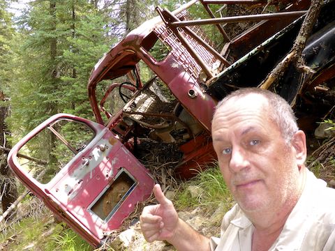
There is an anonymous jeep trail that enters Beaver Park at the third corral, which I followed for at least another mile. About half way along the jeep trail, in the woods at the tip of Rattlesnake Ridge, I spotted the wreck of a Dodge pickup. I had heard there were two wrecks, but could not find the second. (Back at home, after an hour of google image searching, I ID’d the pickup as a 1949/50 Dodge B-Series, based on the arrangement of its grill and headlights.)
Down Beaver Canyon from of Rattlesnake Ridge, FR 92D winds along the edge of Turkey Beaver Ridge, about 150 ft. upslope. Just north of Rattlesnake Ridge, there is a final small prairie. Crossing it, I found an elk skull, which I stuck on a nearby post as warning to any nearby predators. (Or my enemies.) 😈
The next two miles to Turkey Crossing were typical mild Mogollon Rim canyon crawling: Frequent (dry) creek crossings to pick the easiest route through scattered deadfall, ferns, etc. No problemo.
After taking a lunch break at Turkey Crossing, it was 12:30 p.m. If I went further, all the way to Turkey Creek, I would be on the trail probably another four hours. Instead, I decided to take advantage of the presence of FR 92, and hike that out of Beaver Canyon.
As it heads south along Turkey Beaver Ridge, FR 92 alternates between being obvious and nearly indistinguishable jeep trail. There are multiple sections that are overgrown with young pine trees, some as tall as six feet. Sometimes there were orange guidance ribbons hanging from the adolescent pines, other times I determined FR 92’s location by aiming between the small berms that form a dirt road’s edges.
I did not see any bears along FR 92, but twice I encountered elk: First a herd of eight females, and later a single large antlerless elk. Judging by the size a male, but I’m not an elkologist. I also saw a coyote that was so large, I at first thought it was a wolf. (Twenty years ago, Mexican Grey Wolves were introduced to the Mogollon Rim; surely they can’t still be around?) Either way, I kept my head on a swivel for the rest of my hike.
The best part of hiking out where AZ-260 crosses the Mogollon Rim is stopping for post-hike refreshments at beautiful Woods Canyon Lake. I really needed something cold, as I had forgotten to buy ice for the cooler full of post-hike drinks I had in my SUV. Today, I varied from my normal Choco Taco / Drumstick / Strawberry Shortcake ice cream diet, opting instead for a Chocolate Eclair, which paired quite well with the Firestone Walker 805 Pale Ale I purchased from the bait shop. 😍

Directions: Head north on AZ-87, the Beeline Highway, into Payson. Turn right on AZ-260. In 29 miles, after cresting the Mogollon Rim, take the first left onto FR 300 / Rim Rd. In 3.2 miles, at the Woods Canyon Lake intersection, Rim Rd. turns to car-drivable dirt. 9.4 miles from AZ-260 is a t-intersection. Turn left. (Right is FR 34 to Winslow.) In 5.7 miles, there will be a small dirt road to your left, opening on to a Rim-side camp site. Park there.
GPS File: Beaver_Canyon_Mogollon_Rim_Loop
Distance: 11.51 mi.
AEG: 752 ft.
Time: 4h 28m
Hiking Video
Hiking Beaver Canyon, Mogollon Rim from Preston McMurry on Vimeo.