

Working my way around the Phoenix metro area doing winter locals’ hikes, today was Skyline Regional Park’s turn.
Skyline Regional Park has four summits, of which I’ve done two: Valley Vista (2018), Crest Summit (2019), Pyrite Summit and Javelina Summit. None of them are too difficult: Some overly motivated people even do all four in one hike! 🧐
As my last Skyline Regional Park visit was to the east end of the park, towards Phoenix, this time I headed west, towards Pyrite Summit, via Mountain Wash Trail, Turnbuckle Trail, Granite Wash Trail, Pyrite Trail, Pyrite Summit Trail, back onto Pyrite Trail, then looping back to the trailhead via Chuckwalla Trail and Turnbuckle Trail (again). All told, it is 7.0 miles and 1,200 ft. accumulated elevation gain (AEG).
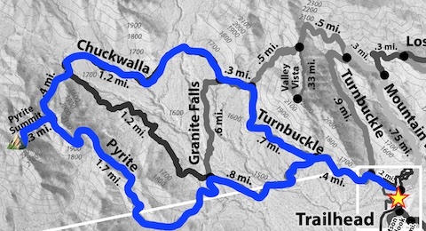
I did the loop clockwise: The climb is more gradual that way, 650 AEG over 1½ miles (an 8% grade), whereas counter-clockwise is 550 AEG in only ¾ of a mile (a 14% grade), even with plenty of switchbacks.
Rain was expected off & on through the weekend in Maricopa County, and it was steadily drizzling as I headed out. 🌧
Skyline Regional Park’s trails are well laid out, and well maintained. Probably better than any other park in Maricopa County. You never have to worry about your footing, not even crossing a wash, so you can spend your time looking around, rather than staring at the ground. (Though the scenery is not the greatest, unless you are on a summit.)
Other than the Pyrite Trail, Pyrite Summit Trail, and the bit of Turnbuckle Trail on the west of Valley Vista, I had previously hiked the trails on this loop. I started hiking at 8:30 a.m., and made the turn onto Pyrite Trail 30 minutes later.
Pyrite Trail starts out like Chuckwalla Trail for the first ¾ of a mile, as it follows a wash very gradually up canyon. Then Pyrite Trail pitches up, climbing 230 ft. in 0.4 miles to saddle. If you see an antenna on a peak just south, that is some sort of aviation beacon, not Pyrite Summit. I suspect the beacon is for Luke Air Force Base, as pairs of F-35 Lightning IIs headed south over it all morning long. Even in the rain. Probably headed out to the Goldwater Range, south of I-8, to play in the box. ⚡️
Pyrite Trail levels out for a ¼ mile, as it follows the contour on the north side of Hill 2034. Just before Pyrite Trail begins climbing again, Pyrite Summit is visible to your left.
Pyrite Trail climbs 200 ft. in the next ½ mile, reaching its high point at the junction with Pyrite Summit Trail. If you look back, you can see the Pyrite Trail winding back down into the valley, with the trailhead in the distance. You’ve come all this way, no sense skipping the summit!
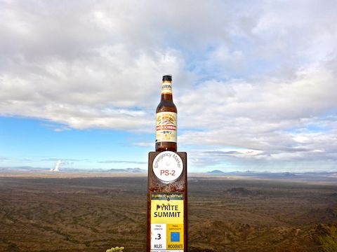
Pyrite Summit Trail climbs 200 ft. in a ⅓ of a mile to the summit, which is marked by a cairn and one of many numerous marker poles. I should have checked for a geocache, but blanked it while enjoying the view. (And a trail beer.) 🍺
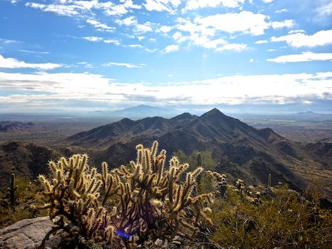
Despite not being very prominent, Pyrite Summit has some solid views, particularly to the south and west, across flatter surrounding terrain. Though they do not show up well in my photos, I could easily identify Woolsey Peak, in the Gila Bend Mountains, Saddle Mountain and, of course, the Sierra Estrella.
After enjoying the Pyrite Summit views, I headed down the steep northern section of Pyrite Trail to the junction with Chuckwalla Trail.
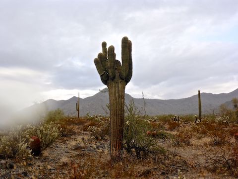
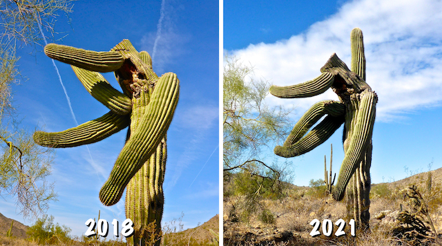
Chuckwalla Trail is a pleasant stroll that crosses a jeep trail — otherwise known as Indian School Rd. (yes, that one) — several times, as it heads east to the foot of Valley Vista. The saguaro in the picture below is just north of the junction with Granite Falls Trail. Both Chuckwalla Trail and Granite Falls Trail had dirt bike tracks. (I heard, and briefly saw, the dirt biker two hours earlier.) Probably came in from the west. Bet there are not any fences out there … 🚧
From the base of Valley Vista, it was a quick 1½ mile jaunt back the trailhead. I was on my way home by noon.
I drove partway home on I-10, before exiting at 35th Ave. to head up to (paved) Indian School Rd. Just south of Grand Avenue, in Maryvale, there was a traffic snarl at an apartment complex where a bunch of cops were pointing long guns at someone. (Or one of the apartments.) Another cop came barreling down the turn lane as I cleared the area. I wonder what that was all about? Hopefully I captured it on my dashcam!
Directions: From Phoenix, head west on I-10. Take Exit 117 onto north Watson Rd. Drive 2.0 miles to the no fee gate, then another 0.9 miles to the end of the road.
GPS File: Pyrite_Summit_Loop
Distance: 7.06 mi.
AEG: 1,236 ft.
Time: 2h 46m
Hiking Video
Hiking Pyrite Summit, Skyline Regional Park from Preston McMurry on Vimeo.