

I’ve been in the Mount Tritle area several times before, most recently a year ago, when my mine exploring buddy Paul and I explored the Blue Dick Mine. However, I’ve only summited Mount Tritle once, and it was so long ago that I hadn’t figured out how to edit videos, so I just uploaded a random segment I shot on my iPhone. I figured it was time to return.
7782 ft. Mount Tritle is one of a string of 7,000+ ft. peaks that separates Prescott from the lower interior of the Bradshaw Mountains. Other peaks in the range include Maverick Mountain (7443 ft.), Spruce Mountain (7496 ft.), Lookout Mountain (7530 ft.), Moscow Peak (7721 ft.), Mount Davis (7897 ft.) and the tallest peak in the Bradshaws, Mount Union (7979 ft.).
Rather than starting from the “forward” trailhead at Kendall Camp, I started hiking a ½ mile back, at the intersection of FR 79 and FR 79A. I figured I could use the extra mile of exercise, but by the time I reached Mount Tritle’s summit, I was wishing I had parked a bit closer. All that remains of Kendall Camp is a an old wood fence and an unnamed spring, which I did not check for water.
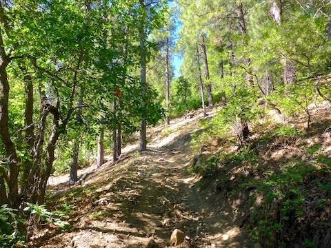
FR 79A climbs a mild 240 ft. in a little over mile to the junction with Kendall Camp Trail #65. Being a forest road, all manner of motorized vehicles may use FR 79A, but I’ve never seen one on it. It’s not long. Trail #65 has four vertical logs across it to prevent ATVs, jeeps, etc. from heading up it. Interestingly enough, motorcycles are allowed on Trail #65. 🏍
Two shorter options, with less accumulated elevation gain (AEG), to the full Mount Tritle summit hike are to do an out & back to either the Kendall Camp Trail #65 posts (2.3 miles, 270 AEG), or do an out & back to the saddle at the top of Trail #65 (4.0 miles, 950 AEG — definitely a quality blow!)
Hiking Mount Tritle is, essentially, a tale of four climbs:
- Kendall Camp Trail #65 climbs 680 ft. in 0.8 miles, a 16% grade, to the Maverick Mountain saddle. There’s lots of shade, but it is slippery, particularly on the descent.
- With no rest, from the Maverick Mountain saddle, the climb continues along FR 9403C, at a less strenuous 250 ft. in 0.4 miles,a 12% grade, to the top of a ridge.
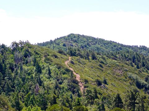
- After crossing, and descending, the shady ridge, you face the Eiger in the picture above: Not far, or high, “only” 156 ft. in 0.12 miles is a heart-pounding 25% grade. There is no cover. And it is extremely rocky, and slippery, both going up & down. 🥵
- After crossing, and descending, a second shady ridge, the final climb of 500 ft. in 0.5 miles, a 19% grade, seems like a relief after the Eiger.
I took plenty of 30-second breathers on the climb up Mount Tritle. Even though it was only 64℉ when I started, the direct sunlight, in the thinner high-altitude air, made it seem warmer. The plentiful shade provided by the pines, juniper and oak were a big relief. The bestest, mostest shadiest pine of all was on Mount Tritle’s summit.
The summit of Mount Tritle was mostly covered with scrub, most of it stabby, but a lot less grabby & painful than catclaw. The true summit, which is accurately marked on the GPS route attached below, is 100 yds. southeast of where the USGS topo claims it is. The topo summit is marked by an old 3′ x 3′ antenna base marked “W7GOK / K7EUR”, the initials “BL”, “TB” and “JS”, and is dated “6-25-61”. A quick google search confirmed my suspicion that the code letters were amateur radio “ham” callsigns: W7GOK was James H. Schultz, and K7EUR was Bill F. Lesko, both of Phoenix. No idea who “TB” was. 📡
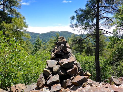
Mount Tritle’s true summit is marked by a small cluster of exposed rock, 100 ft. south of the shady summit pine. According to the topo, there is a wood shack on the summit, but it disappeared years ago. (Topo information can lag reality by as much as 50 years.) There is a 3 ft. high cairn where the shack used to be.
At various spots along the ridge between Maverick Mountain and Mount Tritle, all the peaks I mentioned earlier are visible, plus Granite Mountain, Thumb Butte and Glassford Hill. Also, there are great views southwest, past Wagoner and Walnut Grove in the lush Hassayampa River valley, towards the Weaver Mountains, including Antelope Peak and Yarnell Hill. I could clearly see the large gold & silver surface operation at Zonia Mine, midway between Walnut Grove and Peeples Valley. Closer, a mile down Dosoris Canyon, I could see active operations on lower parts of the Davis-Dunkirk Mine. There was quite a bit of shooting down there. Maybe claim jumpers. 😈
After lunch under Mount Tritle’s shady summit pine, I started back down. Still taking plenty of breathers, and even a 10 minute break near the Maverick Mountain saddle. I put out a bottle cap filled with Gatorade, hoping to attract a hummingbird. No luck: The only thing that flew by were a pair of fighter jets. I looked, but could not spot them — only the bluest sky I have ever seen in my life. 🤗
Directions: From From Gurley St. in Prescott, head south on Mt. Vernon Ave., which becomes the Senator Highway. In 7.4 miles, just after the pavement ends, turn right onto the second dirt road, FR 79 / Kendall Camp Rd. Make a quick right & left to cross the Hassayampa River. Depending on surface conditions & water level, a car could handle FR 79. In 1.8 miles, FR 79A splits right. I’ve parked my SUV a ½ mile down FR 79A before, but this time was no bueno. Instead, I parked at the FR 79 / FR 79A intersection.
GPS File: Mount_Tritle
Distance: 8.46 mi.
AEG: 2,215 ft.
Time: 4h 18m
Hiking Video
Hiking Mount Tritle, Bradshaw Mountains from Preston McMurry on Vimeo.