

I had planned to do a hike up in Yavapai County on Saturday, but PrescottStyle had to work.
Since the temperature was scheduled to top out at only 75° on Sunday — or 32° less than Friday’s record 107° — I figured I could hike locally, in comfort, without having to drive 3+ hours round trip to do it.
I thought about maybe doing something in the White Tanks or the Superstitions, but even those suburban mountain ranges are an hour away from my home in the central Phoenix neighborhood of Sunnyslope.
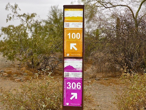
I could have hiked Shaw Butte Trail #306 from my house, but that is a hair under seven miles, and I did not want to find myself short of 50 miles at 6:00 p.m. on the last day of the month, like I did in April. 🙄
I needed more miles.
So, I decided to hike the entire length of Charles M. Christiansen Trail #100 from the east to west.
There’s two trailheads at the east end of Trail #100, a miniscule 6 space lot on Tatum Blvd., just south of Doubletree Ranch Rd., and a 60+ space lot, with room for horse trailers, on 40th St. The Tatum Trailhead adds a mile to the distance, and is always full.
Charles M. Christiansen Trail #100 can be roughly divided into three sections: 1) From Tatum / 40th St. to Dreamy Draw, 2) thence to the North Mountain Visitor Center (NMVC) on 7th St., 3) then for the completists to Mountain View Park on 7th Ave. The first segment is ~4 miles, the second ~5 miles, and the third ~2 miles.
The 40th St. lot, Dreamy Draw and the NMVC have toilets and water.
Most people hike one segment, but MTBs frequently do most of Trail #100. (Parking a half mile north of of the trail’s western terminus, where their vehicles are less likely to broken into by the shady characters which frequent Mountain View Park.) Parking a half mile north on 7th Ave. is legal, but informal; if you feel more comfortable with defined spaces, there’s a lot on Central Ave. at the foot of Shaw Butte. It’s just a hair shorter than 7th Ave.
Being an urban trail, in the Phoenix Mountains Preserve, Trail #100 has innumerable informal side trails. I hiked the official route, the one with the posted smart phone readable QR codes to keep less adventurous hikers on track.
I’ve hiked 8-mile chunks of the Trail #100 before, from the Tatum trailhead to my home, but never the whole thing, end-to-end.
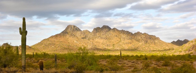
I started at 6:30 a.m., hiking through the lush access corridor between houses off Tatum. After a half mile, I broke out into the open as Trail #100 entered the Phoenix Mountains Preserve. It was cloudy and 62°. The sun only occasionally peeked through the clouds as I crossed L.V. Yates Trail #8, heading across the valley north of Piestewa Peak. Like any hike on Trail #100, there was a mixture of old folks with knee braces and hiking poles, trail runners, dog walkers, families, and mountain bikers.
There’s a ton of wash crossings the entire length of Charles M. Christiansen Trail #100, so it pays to keep your eyes up, head on a swivel, and be listening behind you, in case some mountain biker is having professional fantasies and blasts over the edge of a wash, surprising you. Today, all but one were courteous and friendly.
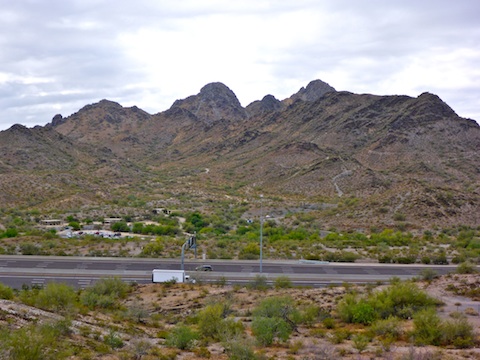
I hit Dreamy Draw just before 8:00 a.m. taking a brief break, on my feet, before heading under AZ-51. On the west side of the tunnel, I normally split north as it is a bit shorter. (Though with one very steep 60 ft. “climb”.) The official Trail #100 splits left, offering thrilling elevated views of the freeway’s traffic.
When the two options rejoin, they follow the west edge of several neighborhoods, before crossing a saddle towards Cave Creek Rd. I passed one horse rider, yielding to him as I do to everybody. (Despite trail ettiquette being MTBs yield to pedestrians, who yield to horses, it’s just easier to yield to everybody.)
The graffiti I had seen on the Cave Creek Rd. tunnel just a few weeks ago has already been painted over. Phoenix has been very aggressive about graffiti mitigation the last few years.
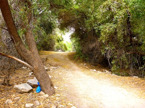
On the west side of the Cave Creek Rd. tunnel, is another short lush area, before Trail #100 climbs past the park ranger’s hilltop house. The trail gets narrow, in a deep rut, so be especially alert for MTBs headed downhill.
At the top of the short climb, Trail #100 splits in multiple directions. Most bikers & hikers take the wide path through the valley between two low ridges. But Trail #100 actually splits left, heading along the crest of the southern ridge. There are so many informal trails in the area, that the first 60 times I hiked it, I never repeated a route.
Trail #100’s third, and final, lush section is where it passes between the Pointe Hilton Tapatio Cliffs and the Sheriff’s Posse, just east of 7th St. The North Mountain Visitor Center is just past the west end of the 7th St. tunnel.
I took my second break, this time sitting, at the NMVC. I texted my wife to ask her to pick me up at the end of Trail #100 in about 35 minutes.
From the NMVC, Trail #100 turns south into the “bowl” between Shaw Butte and North Mountain. The 7th St. trailhead comes into view with less than a mile to go. The trail then crosses an earthen dam, and skirts a school, before ending just past a jungle gym in Mountain View Park.
My last time looping Shaw Butte, I had stopped about every fifth of a mile to take a photo straight up trail. In my hike video, I timed each photo at two seconds. Today, I shot every two minutes. At my normal urban pace of ~3 mph, that would be a photo every .10-.12 miles, or 8-10 photos per mile. For an 11 mile hike, that would end up being 90-110 photos. Even at two seconds per photo, the resulting video would be 3-4 minutes long. That’s as long as my adventurous hikes, so I dropped the transitions between photos and set each photo to only one second. Not counting the title card at either end, the video is instead only 2:14 long. Let me know below what you think! ![]()
GPS File: Charles_M_Christiansen_Trail_100
Distance: 10.87 mi.
AEG: 985 ft.
Time: 4h 30m
Hike Video
Hiking Trail #100, Phoenix Mountains Preserve from Preston McMurry on Vimeo.