

The past year or so my regular hike day is Thursday. But Arizona temperatures were scheduled to peak on Thursday — including 90℉ in Show Low. However, temps were supposed to drop 5° on Friday, and another 10° Saturday through Tuesday. Then again, the north country is a zoo on the weekend, as Phoenicians jam I-17 and AZ-260 heading to points north and east. The more I can avoid other people, the better. So, I waited until Monday. 🌡
I decided to hike Buena Vista Trail #637, just south of Show Low, in Navajo County. Buena Vista Trail #637 is part of the White Mountain Trail System, which is an interconnected trail system stretching 35 miles, as the crow flies, from Pinedale, to Pinetop-Lakeside, to Vernon.
The last time I hiked the White Mountain Trail System was 2012. My wife was away for the weekend, so I took off as well, hiking Springs Trail #633 and Los Burros Trail #631. 2012 was so long ago, I actually carried a paper map!
After the three hour drive from Phoenix, my wife & I arrived at the Buena Vista #637 trailhead at 9:00 a.m. For a small trailhead, in a small town, it was packed: I counted at least 10 vehicles. (There may have been more, but I ran out of fingers.) ✋🤚
Despite the crowded trailhead, on Buena Vista Trail #637 I only encountered two hikers about halfway, two hikers near the end, three ATVs moving too fast for conditions, and no mountain bikes, dog walkers, or horse riders. Only three vehicles were left at the trailhead when I returned at 2:00 p.m.
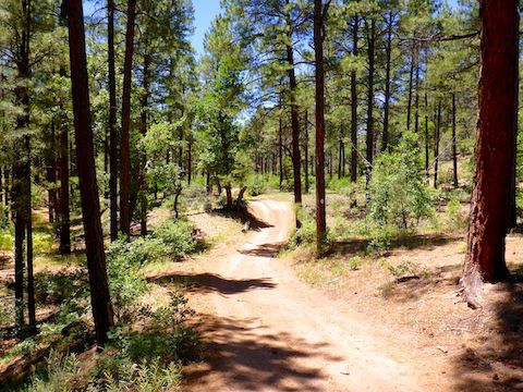
Buena Vista Trail #637 starts as a single-track on the right side of the information kiosk. It soon switches to jeep trail. Most of the loop is on those old forest roads, including FR 9703T, FR 9704T, FR 9704B, FR 9703X, FR 300E. Usually, the more letters and numbers in a forest road number, the smaller & rougher it is. Not so on this hike: The dirt roads are generally fine for walking. (Though there were a couple I’d avoid in an SUV.) Just past the shortcut, descending the north side of Hill 6773, some of the trail has been optimized, with switchbacks, for mountain bikes.
If you are hiking clockwise, Buena Vista Trail #637 has a short cut a mile in. (Two miles, if you are hiking counter-clockwise.) The short cut is only 150 yds. of jeep trail, so folks looking for a quick & easy stroll through cool pines have a 3-mile, 200 AEG (accumulated elevation gain) option available.
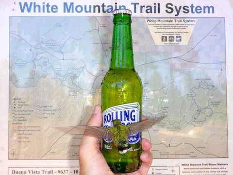
There’s good maps posted at the Buena Vista Trail #637 trailhead, and apparently some are occasionally available to take along. However, I recommend carrying a GPS (route available below): The official loop is criss-crossed by uncountable other jeep trails and mountain bike paths. I hiked 1½ extra miles due to wrong turns, and the couple I met near the end had just gotten un-lost. 🧭
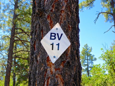
The White Mountain Trail System is marked with reflective white diamonds, affixed to trees. Every ¼ mile or so the marker has an abbreviation and number indicating which trail you are on, and where on that trail. Buena Vista Trail #637 is abbreviated “BV”. Since the trail surface is mostly free of ankle breakers, keep your head up so you don’t wander off like I did. If you do get lost, call in the code.
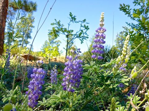
I was surprised by the wide variety of flowers along Buena Vista Trail #637: Lupine and western wallflower were among the more numerous, while a saw only one or two penstemon, paintbrush and prickly pear flowers. My favorite “flowers” were painted on a small rock I spotted 7 ft. up in a tree. The first time I noticed “pebble painting” was last year on the Black Mesa Loop. I left those ladybugs behind, but I took the flower rock with me: I figured my wife would like it for her birthday, the next day. 🐞
The 1,200 ft. of AEG on Buena Vista Trail #637 mostly occurs in a half dozen 150-200 ft. climbs. Nothing too strenuous. The best views on the loop, occur from a clear “summit” 4.0 miles into the hike. The hospital in Pinetop-Lakeside was obvious, as were the antennas on Porter Mountain and the quarry at First Knoll.
There’s a lot of sun on Buena Vista Trail #637, but also plenty of shade. Besides a break from the sun, the pines also moderated the high winds (speeds in the upper 20s, with gusts up to 41 mph).
I finished the Buena Vista Trail #637 loop in 3h 54m, which — more math — is 2.96 mph, a speed akin to my neighborhood walks during the week. The hike is is not spectacular by any means, but I enjoyed the pleasant stroll. 🙂
On the way home, I diverted off AZ-260 in Pinedale so I could drive through the covered bridge — apparently the only one in Arizona — just for my loving & supportive wife, who had always wanted to drive through a covered bridge. Happy birthday, Schnook! 🤗
No hike today (Thursday), due to the short turnaround from Monday. Next up on my hike list are continuing my quest to hike every named canyon on the Mogollon Rim, then my annual return to the Pinaleno Mountains.
Directions: Depending on where you live in the Valley, there are two general ways to get to Show Low: From the south & east Valley, take US-60 through Globe. At the Motel 6, turn left to continue on US-60. In 81 miles, turn right on Rim Rd. Park on the left. From other parts of the Valley, exit the Loop 101 at Shea. Go east on Shea to the Beeline Highway (AZ-87). Go north on the Beeline Highway for 61 miles to AZ-260 in Payson. Go east on AZ-260 for 87 miles to the first stop light in Show Low. Turn right on US-60. In 3 miles, just before entering the Fort Apache Reservation, turn left on Rim Rd. Park on the left. From my home in Sunnyslope, both routes are about the same distance & time.
GPS File: Buena_Vista_Trail_637
Distance: 11.53 mi.
AEG: 1,277 ft.
Time: 3h 54m
Hiking Video
Hiking Buena Vista Trail #637, Arizona from Preston McMurry on Vimeo.