

After driving nearly 500 miles up from Phoenix, my wife and I were spent the week in Mountain Village, the ski resort above the city of Telluride. As with most of our other trips, I wanted to get a hike in while I was there.
Colorado is chock-full of hiking trails. Heck, when we rode the Durango & Silverton Narrow Gauge Railroad back in 2008, it made several remote stops to drop off, or pick up, backcountry hikers. But, it seems to me, most of Colorado’s mountain trails are steep, long, or steep & long. In other words, a bit beyond my middle age fat guy ability. 👴🏻
However, Telluride, even though it is located in a box canyon, has several trails for people of more modest ability. I chose Bridal Veil Falls, which is scenic, nearby, and with a good workout for its short distance.
Bridal Veil Falls is two miles southeast of Telluride, at the head of a box canyon which, as far as I can determine, has no name. Bridal Veil Creek flows north from Lewis Lake, through Bridal Veil Basin, to the northwest face of Ingram Peak, where it tumbles over a cliff into the canyon below. Ingram Creek, flowing northwest from Ingram Basin, flows over the same cliff, a ½ mile away, forming Ingram Falls. About ¾ of a mile west of their respective falls, Bridal Veil Creek and Ingram Creek join to form the San Miguel River.
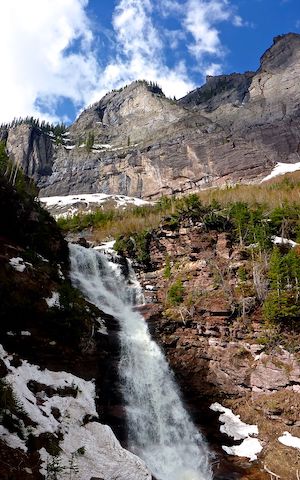
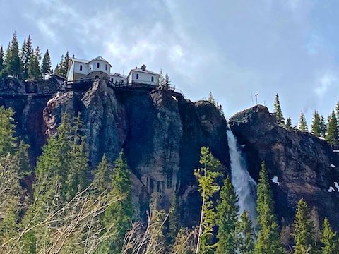
At 365 ft., Bridal Veil Falls is the tallest free-falling waterfall in Colorado. (Meaning, it has the longest single drop at angle more than 80% vertical.) The Smuggler-Union Hydroelectric Power Plant, a white frame building atop Bridal Veil Falls, typically provides 350 kW of power to Telluride. ⚡️
Black Bear Pass Rd., a continuation of Colorado Ave., the main road through Telluride, switchbacks up the head of the canyon between Bridal Veil Falls and Ingram Falls. Only high clearance 4x4s should proceed past the Bridal Veil Falls Trailhead. It is legal to drive as far as the top of Bridal Veil Falls, but after that traffic is one way only, down canyon. (The portion of Black Bear Pass Rd. infamous as the most dangerous jeep trail in Colorado.)
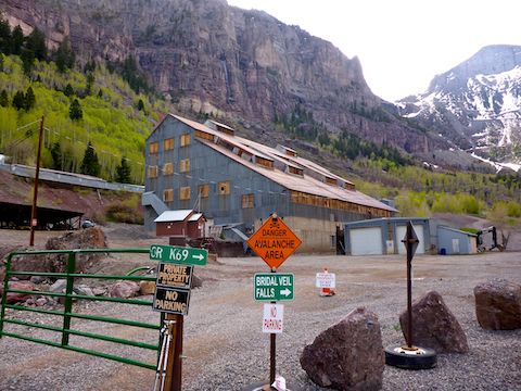
When my wife and I arrived at the east end of Telluride, a San Miguel County road crew had the road blocked off for yearly maintenance, so we parked on the road, west of Pandora Mill. At 9:00 a.m., on a off-season Thursday, there were four other vehicles there.
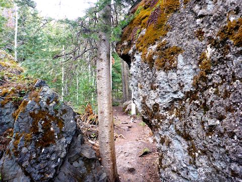
Before 2020, the only approved route to Bridal Veil Falls was up Black Bear Pass Rd. Last May, Bridal Veil Trail — an actual hiking trail — was opened. Mountain bikes are not allowed on the hiking trail; and probably not horses either, due to tight squeezes between boulders. Both horses and MTBs should use CR K69 to access the falls. ⛔️
My plan was to hike Bridal Veil Trail at least as far as in the Ingram Creek crossing and, if safe, all the way to Bridal Veil Falls. If Ingram Creek was too dangerous to cross, I would double back to the trailhead, then hike up Black Bear Pass Rd.
The first 100 yds. of Bridal Veil Trail stay close to Black Bear Pass Rd. before turning south towards Ingram Creek. Mind your footing with roots and stepping between rocks. Ingram Creek is in ⅓ of a mile. Crossing it was no problem at all. “Hazardous stream crossing” is way over blown. (Unless there is a flash flood.) 😏
The vegetation is a mixture of fir trees, aspen and small evergreen shrubbery. I saw two species of flowers, but neglected to photograph them. While laying on the ground, a pair of hikers stopped to ask me if I was okay. “Yeah, just taking pictures of these tiny molds.” “Cool!” But it was nice of them to check.
300 yds. past Ingram Creek, there is a 30 ft. waterfall. (Marked as Side Falls #1 on the GPS route attached below.) The temperature drop in the waterfall’s vicinity was noticeable. Speaking of temperature, I had been worried that I was under-dressed with only a hoodie, as it was quite chilly when I started. But other than the waterfalls’ microclimate, it warmed up enough to be a pleasant late morning hike. 🤗
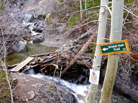
300 yds. past the first side waterfall, was a second, slightly taller and less vertical waterfall. Both are on Bridal Veil Creek. Just beyond Side Falls #2, is the signed junction of Ingram Spur Trail. The sign marks the ¾ mile point of Bridal Veil Trail. I stayed right on Bridal Veil Trail.
… Which I soon lost in a snow bank. Bridal Veil Falls is visible from much of the Bridal Veil Trail, and the way up the drainage was fairly obvious, but I wanted to lay down an accurate track, so instead of bushwhacking, I doubled back to the sign., following Ingram Spur Trail along a contour to Black Bear Pass Rd. (If you start up Black Bear Pass Rd., then take Ingram Spur Trail to Bridal Veil Trail, that route bypasses the Ingram Creek crossing.)
Black Bear Pass Rd. has a similar distance and elevation profile to Shaw Butte, in Phoenix, climbing 840 ft. in 1.5 miles. Bridal Veil Trail also climbs 840 ft., but in only 1.0 miles. The hiking advantage of Black Bear Pass Rd. is views of the Telluride Via Ferrata and Ingram Falls, and better photographic angles on Bridal Veil Falls. I got a kick out of finding a snowman on the road. ⛄️
At the bottom of Bridal Veil Falls, I found the top of Bridal Veil Trail, so I doubled back to where I lost it — I recognized a crushed bush — then headed back up to the falls, laying down an accurate final ¼ mile of GPS route.
I spent about 20 minutes at the base of Bridal Veil Falls. There’s a lot of mist, so I tried to time the swirls to get a relatively clear shot. By the time I was done, I figured it was enough for the day, so I skipped hiking four more Black Bear Pass Rd. switchbacks to the top of the the falls. (Just under 500 ft. and another mile.)
On the way back down Black Bear Pass Rd., there was a steady trickle of people heading up. There were a ton more cars parked near the Pandora Mill. I imagine it would be a zoo on the weekends!
Directions: From the CO-145 traffic circle at the west end of Telluride, simply drive east on Colorado Ave., all the way through town, past the tailings ponds, and the Pandora Mill, to the trailhead. CR K69 (Black Bear Pass Rd.) continues up & left. If you have a high clearance 4×4, you may legally drive as far as the top of Bridal Veil Falls, 2.4 miles past the trailhead. After that, it is one-way traffic, downhill only.
GPS File: Bridal_Veil_Falls
Distance: 5.68 mi.
AEG: 1,070 ft.
Time: 2h 19m