

I was going to ride some mellow forest roads on the Mogollon Rim, but decided instead to hook up with my unicycle-riding buddy Prescottstyle to check out the new Bean Peaks Gravity Flow Trails at White Spar, just south of Prescott. As I sit here in pain, I wish I had kept to that plan.
Bean Peaks Gravity Flow Trails opened just this spring, 2024. The 9.2 miles of trail incude advanced, intermediate and beginner trails. Most of of the trails are one way, and mountain bike only. Phase 2 will add 6.9 miles of trails by spring, 2025, and Phase 3 will finish with 4.7 miles of trail — including to the summits themselves of Green Bean Peak and West Bean Peak — by spring, 2026. 🚵🏻♂️
The system is being built by a partnership of Prescott Mountain Bike Alliance, International Mountain Bicycling Association, Prescott National Forest, and others.

Prescottstyle and I planned to bike the Bean Peaks Gravity Flow beginner trails Green Bean, Mr. Bean, Rice and Beans, and Beany Baby, before adding some “easy” distance miles on other nearby trails.
While perusing the map at Junction 1, a group of four bikers rolled up. One of the guys had crashed, tearing up his lycra. Maybe they descended black diamond Spicy Bean? 😬
Green Bean is the left most trail at Junction 1. Green Bean is uphill only for bikes. Hikers are allowed both ways, but we didn’t see any on a Wednesday morning. To me, a flatlander from Phoenix, the climb up Green Bean seemed steep: It is a net 180 ft. gain in 0.80 miles — the equivalent of 225 ft. in a mile. I try to stay under 140 ft. per mile. After several breathers, we made it to Junction 2A in thirteen minutes.
Like other Bean Peaks Gravity Flow Trails intersections, Junction 2A has a map. Trails radiating from the junction are marked with a fiberglass post indicating either “Do not enter” in red, or the trail’s name, number, and what mode of transport is allowed on it. (MTB or pedestrian — no horses.)
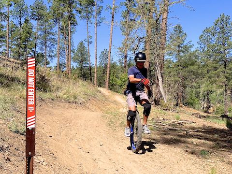
Mr. Bean is the left most trail at Junction 2A. Mr. Bean is uphill only for bikes. Hikers are allowed both ways, which essentially makes Mr. Bean and Green Bean an in & out for hikers. Mr. Bean is a net 66 ft. gain in 0.48 miles. More in my gain wheelhouse, even at 5,880 ft. elevation. I don’t recall walking any of it. We made it to Junction 3 in only eight minutes. (About half my flat Phoenix canal path speed.)
At Junction 3, we briefly considered taking a crack at intermediate Limey Bean, but decided better of it. (Limey Bean? Why not Lima Bean? Probably because everybody hates lima beans!) 😆
Rice and Beans is the second right trail at Junction 3. Careful not to take the first trail to the right, which is Bean Sprout, an intermediate freeride (i.e. jumps and tricks). Rice and Beans is one-way, bikes only, so no need to worry about smacking into anyone who hasn’t crashed. Rice and Beans drops a net 60 ft. in 0.41 miles, so I picked up speed, but not too bad. I did walk it over a few rocky sections. We made it back to Junction 2A in five minutes.
Beany Baby is the trail just to the left of the Junction 2A mapboard. Prescottstyle went first, but I soon passed him because unicycles are constant peddling — no “neutral” — and, with only one tire, have a smaller contact patch. With no ups, Beany Baby drops 175 ft. in only 0.53 miles. I rode a bypass around the one rocky jump. I for sure used my brakes, but I never dabbed. Fast & fun! 👍
Rather than do another Bean Peaks Gravity Flow Trails loop, from Junction 1 we headed east on FR 67 / Schoolhouse Gulch Rd. I figured it would be a relatively flat ride to Upper Goldwater Lake. I was wrong.
FR 67 / Schoolhouse Gulch Rd. climbs 450 ft. in 1.9 miles. That’s 237 ft. / mile, or well above my previously mentioned 140. I tried, but quickly gave up. Prescottstyle basically walked the whole thing. FR 67 / Schoolhouse Gulch Rd. continues on towards some houses, so at the 1.9 mile mark we turned left towards Upper Goldwater Lake, on an unnumbered trail. After 0.4 miles on the unnumbered trail, we turned left onto Goldwater Lake Trail #396.
Goldwater Lakes Trail #396 is narrow, very twisty, and slighty off-camber. It climbs for a half mile, but then descends 360 ft. in 1.5 miles to Bannon Creek. I just want to get some exercise and enjoy the scenery, not crash. Which I did, harmlessly, twice. (Trailside duff is like oil on a race track.) I walked most of Goldwater Lakes Trail #396. Pushing a 30 lb. bike is still exercise!
From Bannon Creek, Goldwater Lakes Trail #396 climbs 125 ft. in only 0.3 miles. Naturally, we walked that as well. At the top of the climb, we turned left onto Bannon Creek Trail #61. It was all downhill from there. Literally.
Bannon Creek Trail #61 descends quick & straight. I let Prescottstyle get well ahead of me, so I would have plenty of runoff, then let it rip. I have no idea how fast I was going, but all of a sudden there were double 6″ inch ruts across the trail. The first one got me squirelly — and I thought I might be able to recover — but the second rut put me down. Hard. Really hard.
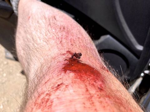
I wasn’t knocked out, but I lay there for 15-20 seconds getting my wits about me. I got up and assessed the damage: The above, plus gash on right elbow, road rash on right shoulder blade, ribs sore on both sides, jammed shoulder in pain, bruise on right temple (good thing for helmets!), various gravel divots. I must have landed shoulder first, then head. 🤕
Prescottstyle was long gone. I limped the 0.8 miles back to the White Spar Trailhead.
This week, I discovered my GoPro has a time-lapse mode. The default is one frame every 0.5 seconds. (As opposed to a normal filming rate of 30 fps.) In other words, 28 frames is missing every second. I thought that would make a long video shorter. And indeed it did: Instead of my ride being spread along thirteen 12-minute video segments, it used less than two 8-minute segments.
Back home, recovering, I watched the time-lapse footage. Herky-jerky like the Keystone Cops. Sucks. At least if you are going to hurt yourself, you should get good video of it! 😆
White Spar Trailhead: From Phoenix, head north on I-17. Take exit 262 west onto AZ-69. Stay on AZ-69 until it turns into Gurley St., in Prescott. Turn left on Montezuma St. / AZ-89, at northwest corner of Courthouse Square. In 2.9 miles, just south of Prescott, turn left into White Spar Campground. The bike trailhead is on the right.
GPS File: Bean_Peaks_Gravity_Flow_Trails
Distance: 9.09 mi.
AEG: 1,038 ft.
Time: 2h 42m