

I was too wore out last Thursday — after hammering out two blogs and two videos from our Telluride trip — to do an “away” hike. Sunday was Mom’s 80th birthday, so instead, I compromised by hiking the Alamo Springs Loop in the Tortolita Mountains, which overlook her home in Marana.
When I got home, my crappy Garmin 62s was missing. Not in the car, not in our house and not in her house. F**k me. My wife has Amazon Prime, so I used her account to buy a new GPS. Though it’s out-of-date and — unfortunately — a Garmin, I ordered a 64sx. At least it has the same buttons in the same places. Muscle memory is important.
The next day, I found my crappy Garmin 62s. Of course. 🙄
At least now I am able to set up the 64sx as close as possible to the 62s, and on today’s hike tested them side-by-side for accuracy.
East Clear Creek (ECC) starts on the Mogollon Rim, initially draining Lake Draw, Cienega Draw and Quaking Aspen Canyon. ECC winds ~40 miles northeast, past Kehl Canyon and McCarty Ridge; through the C.C. Craigin / Blue Ridge Reservoir; past Barbershop Canyon, Yeager Canyon and the hamlet of Blue Ridge; to Leonard Point, where it joins with Leonard Canyon to form, simply, Clear Creek. In turn, Clear Creek continues north, eventually emptying into the Little Colorado River just east of Winslow.
As part of my ogoing effort to hike all the named canyons on the Mogollon Rim between Strawberry and Woods Canyon Lake, East Clear Creek was the second of my eight scheduled 2021 Rim canyon crawls. Not the whole thing, mind, only the four miles above Jones Crossing on FR 141. 😉
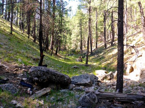
Starting from Dry Lake, on FR 612, I planned to descend an unnamed drainage to East Clear Creek, follow the creek north to Jones Crossing, visiting a cave along the way, then double back on less-traveled forest roads to my trailhead.
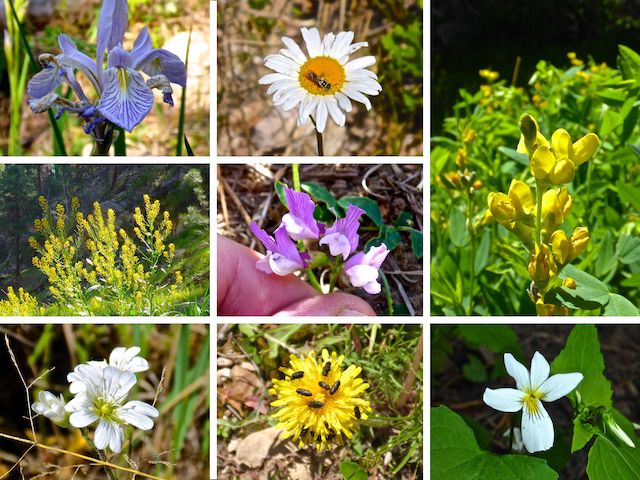
Middle Row: some type of groundsel or goldenrod (?), aspen pea.
Bottom Row: chickweed, dandelion, Canada violet.
Considering Memorial Day — the traditional beginning of “summer” — was last weekend, I was surprised how few RVs were camped along FR 141. There was nobody at Dry Lake, and only two ATVs rode past my patient wife while I was gone.
The Dry Lake – East Clear Creek Loop starts by heading south on FR 612 for 250 yds. to FR 612B. Motorized vehicles are not allowed past the wire-looped gate 250 yds. east on FR 612B. (Though I saw tracks.) A ½ mile into the hike, when FR 612B bends north (left), there is an old fire ring on the right. Turn off the road, heading for the low ground past the fire ring. A ¼ mile past the fire ring, I crossed FR 612C, on which I planned to return. 🏕
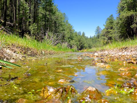
After crossing FR 612C, the drainage gets narrower and deeper the next ¾ of a mile to East Clear Creek. The bottom is nearly obstacle-free, and often grassy. There were quite a few Rocky Mountain iris just before ECC: Mostly violet, but some were pure white.
As I reached East Clear Creek, I almost bumped into someone. He had a clipboard, instead of hiking gear. Turns out he was doing forest research, though I neglected to ask if he was researching trees, critters or flowers.
Speaking of flowers, I found a fair number of species on the East Clear Creek – Dry Lake Loop, but visual coverage was minimal. Small white asters were the most common. Besides avoiding tripping hazards, another reason I pay such close attention to where I am stepping is finding what flowers there are. And that is why, hidden under some grass, I saw a brief glimpse of purple that turned out to be the tiny aspen pea, above. 🕵🏻♂️
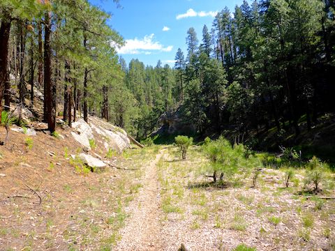
Despite my concentration on my footing, travel at the bottom of East Clear Creek was as easy as could be. In many Mogollon Rim canyons, you will find 50 yds. of faint path here or there, but in ECC there is a obvious path pretty much the whole way to Jones Crossing.
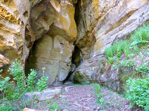
The East Clear Creek cave is 3.25 miles into the loop, on the right, on the creek’s shelf. It goes in a fair way. Besides the entrance there is overhead lighting through a crack. The cave looks more like two hills mooshed together to form a slot canyon, than a cave cave. It is much cooler inside, and there is not too much bat or rat poo.
If you wanted to do a shorter day hike from your Dry Lake camp, an out & back to the East Clear Creek cave would be 7.6 miles and 370 ft. AEG (accumulated elevation gain). Out & back from Jones Crossing, a trip to the cave is 5.3 miles, 160 AEG. Otherwise, the full loop is 9.7 miles, 570 AEG. 🗺
I took a short break at Jones Crossing, before I started hiking forest roads back to Dry Lake. There’s a number of forest roads that head south from FR 141 towards Dry Lake, but FR 141 is a “main” dirt road, so I chose the path that used it the least: FR 726D, FR 6437A and FR 612C. Imagine my surprise: I did not see one vehicle the 30 minutes I was on FR 141!
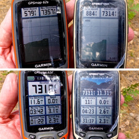
Comparing my old Garmin 62s and new 64sx, there are elevations of 7318, 7314 and 7311 — meaning the 64sx isn’t even agreeing with itself! The correct elevation is 7314. The “total ascent” (i.e. AEG) differ by 50%. The actual AEG is 634 ft.
Distance more closely matches, as 11.3 miles (62s) is only 3% less than 11.6 miles (64sx). I attribute the difference to the number of data points each GPS recorded, 1061 (62s) vs. 1715 (64sx). More frequent sampling should be more accurate for distance, but it wasn’t, being off .76 miles to 10.84 (62s) and .83 miles to 10.48 (64sx).
I started hiking at 8:08, taking three 10-minute breaks and shooting numerous photos, before finishing at 1:18 p.m. (A duration of 5:10.) The moving time, stoppage time, and total time — 5:04 (62s) and 4:55 (64sx) — wildly vary. I didn’t think to use my watch’s chronograph for comparison. I’ll do another test next week, when I hike Blue Ridge National Recreation Trail #107 in the White Mountains.
Directions: From Phoenix, head north on AZ-87, the Beeline Highway, through Payson, Pine and Strawberry. (Alternately, take I-17 north, then AZ-260 east.) 10.8 miles north of AZ-260, turn right onto FR 141. In 1.7 miles, turn right onto FR 612. Dry Lake is on the left one mile later. Park there.
GPS File: East_Clear_Creek_Dry_Lake_Loop
Distance: 10.48 miles
AEG: 634 ft.
Time: 3h 42m
Hiking Video
Hiking East Clear Creek to Jones Crossing from Preston McMurry on Vimeo.