
 on the summit of Mount Lemmon. I found orange sneezeweed as low as 7,900 ft. el., near Mint Spring.")
I’m trying to make Mount Lemmon, and its environs, an annual summer hiking trip. Don’t get me wrong: I enjoy hiking the much closer Mogollon Rim, but some variety is nice as well. Not just for me, but for you, my vast worldwide audience. 😏
Today’s plan was to hike Mint Spring Trail #20 from Mint Spring Trailhead to Marshall Saddle, Aspen Trail #93 up Mount Lemmon, then follow the utility road through the antenna farm to the true summit, adjacent to Mount Lemmon Observatory’s SkyCenter. After signing the summit log, I would double back through the antenna farm, taking the old summit jeep trail back down to Mint Spring Trailhead.
Mint Spring Trailhead is on Carter Canyon Road, the first right after Cookie Cabin Pizzeria, in Summerhaven. Mint Spring Trailhead is the pullout just before Carter Canyon Road ends at a private property sign. There is no picnic table, nor pit toilet, but at least it isn’t crowded like nearby Marshall Gulch Trailhead.
After the bicycle-dodging drive up the Catalina Highway from Tucson, I started hiking at 9:30 a.m. The start of Mint Spring Trail #20 was not obvious, due to the carsonsite marker being obscured by brush. Inside the brush, on the opposite side of a small creek is a map board. I’d move the map board out to Carter Canyon Road, so Mint Spring Trail #20 would be more obvious, but no big.
The first half mile of Mint Spring Trail #20 is heavily forested, bracken fern underlying mostly quaking aspen. There were some nice clusters of yellow columbine flowers, but nothing like on Butterfly Trail #16 in 2021. 🐝
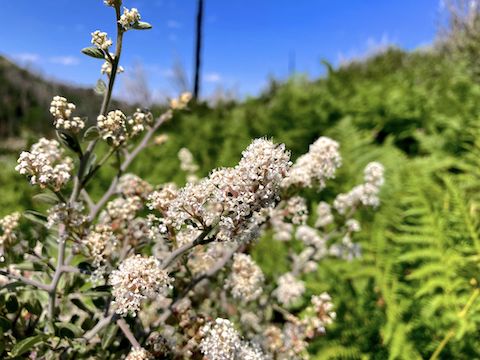
Mint Spring Trail #20 then enters the Bighorn Fire burn area. A few small trees or large shrubs are still standing, but the trail is otherwise exposed. Post-fire shrub growth crowds the nice trail surface in several spots. Fendler’s ceanothus, a flowering shrub, was quite common. There were lots of buzzing things amongst the flowers, so I was spreading positive waves to anything which might sting.
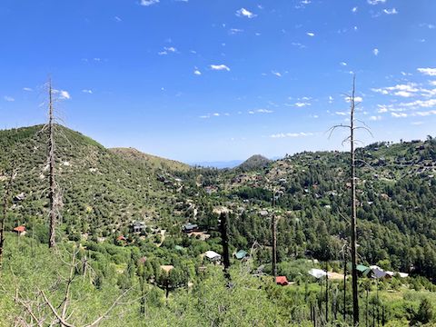
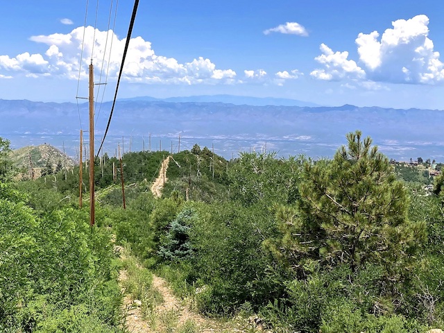
As Mint Spring Trail #20 bends west, around the southeast spur of Mount Lemmon, it begins slowly descending towards Mint Spring. That spur is a good OP overlooking Marshall Peak, Marshall Gulch, Spencer Peak, Inspiration Rock, and the antenna farm on Bigelow Peak. After crossing Mint Spring, I briefly lost the trail in one of several rocky sections. The climb up Aspen Trail #93 is briefly visible.
Mint Spring Trail #20 has some nice, small, boulders the final third of a mile to Marshall Saddle. Mint Spring Trail #20 ends there after 1⅔ miles. I’d met two hikers along the way, and several more were enjoying the Marshall Saddle shade, or climbing up from Wilderness of Rocks. I didn’t dally long, quickly turning onto Aspen Trail #93. (On which, ironically, I don’t recall any actual quaking aspen.) 🌲
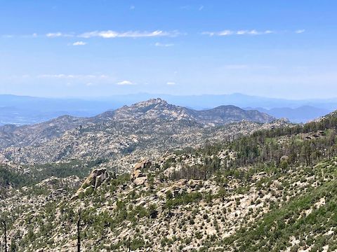
Pine trees provided spot shade along the first half mile of Aspen Trail #93. The trail surface was still decent, but there were a few step-ups, and sections where a fall could send you for a long tumble. Some nice views were visible through the trees, particularly southwest, towards Cathedral Rock and Mount Kimball. Past those, 22 miles distant, I could see the Tucson Mountains.
The final mile of Aspen Trail #93 resembles Mint Spring Spring Trail #20, in that it was heavily fire-damaged, exposed, and occasionally brushy. Fewer flowers though, but more than in the pines. Aspen Trail #93 climbs a hair over 1,000 ft. in 1½ miles. It’s the same 13.1% grade as North Mountain, but double the gain, and no pavement. I thought the climb gained 1,600 ft., so that was a relief! 😅
The antenna farm access road continues to climb as it heads a half mile west to Mount Lemmon’s summit. After the blow up Aspen Trail #93, it was barely noticeable. I briefly checked out the ski lift, but it wasn’t running. (Off-season rides are available Thursday-Monday, but today was a Wednesday.)
Besides the high country flowers pictured above & below, I also spotted fleabane on the upper reaches of Aspen Trail #93, western yarrow, red and yellow pea, both pineywoods & Richardson’s geranium, and some barely blooming mullein. Might have been pygmy bluet, but I didn’t look close, so that could have been the similar Plummer’s candyleaf. Scarlet penstemon were found throughout the hike.
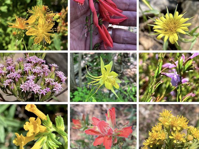
Top Row: Scouler’s St. Johnswort, scarlet penstemon, yellow salsify.
Middle Row: Plummer’s candyleaf, yellow columbine, aromatic false pennyroyal.
Bottom Row: Manyflowered stoneseed, paintbrush, Wright’s goldenrod.
I was surprised how many civilian vehicles were on top of Mount Lemmon: I thought it would just be a few comm guys. There’s actually a pay lot / trailhead at the end of Ski Run Road: The Mount Lemmon Recreation Area is $8 / day. (Though parking along Ski Run Road appears to be legal.) Unfortunately, just before I reached Mount Lemmon’s true summit, at the SkyCenter, my way was barred by a locked gate.
I am informed by a twitter follower that the true summit is accessible by working your way east, then north, along the SkyCenter fenceline. I’ll hit that up next year. 👍
After some lunch, I doubled back through the antenna farm. Rather than head down Aspen Trail #93, the longer route back to Mint Spring Trailhead, I stayed on the dirt road as it got steep and rocky. I guess the old-timers didn’t believe in switchbacks. I slipped twice, but managed not to fall. Though tired, it was easier to keep moving as everytime I stopped my quadricep would tremor. (Going downhill is harder than you think.) I finished at 2:00 p.m., and it was off to La Hacienda for birthday dinner!
Directions: From I-10 in Tucson, take Exit 256. Head east on Grant Rd. for 8.5 miles. Turn left onto Tanque Verde Rd. In 3.3 miles, turn left onto the Catalina Highway. Drive 29.5 very twisty miles (speed limit 35 mph), into Summerhaven. Take the first right after Cookie Cabin Pizzeria, at the brown Mint Spring Trailhead sign, onto Carter Canyon Rd. The trailhead (a pullout) is 0.5 miles ahead on the right.
GPS File: Mint_Spring_to_Mount_Lemmon
Distance: 6.27 miles
AEG: 1,560 ft.
Time: 3h 12m
Rumble Video
Vimeo Video
Hiking Mount Lemmon from Mint Spring from Preston McMurry on Vimeo.