
.")
Indian Mesa Ruins is another one of those hikes I’ve had on my to-do list for years. Not sure why I’ve never gotten around to it: Indian Mesa is close to Phoenix and easily accessible. Maybe because of the bald eagle nesting closure around the north end of Lake Pleasant, from December 15 – June 15 every year. You certainly don’t want to be doing this hike in July or August! Nope, early December is ideal.
The Upper Parking Lot trailhead for Indian Mesa Ruins is located 1½ miles west of the Black Canyon Trail, on Table Mesa Rd. Yes, “Table Table” Road. For all intents & purposes, Upper Parking Lot is the end of Table Mesa Rd. ✋
Sure, Table Mesa Rd. is SUV-able for another two miles to the White Bluffs, but the way is barred by three heavy, locked, gates. The first locked gate is at the Upper Parking Lot, with signs that announce the Upper Parking Lot opens at 6:00 a.m., the road is closed, but somewhere further on the Bald Eagle Trailhead and Agua Fria Trailhead open at 5:00 a.m. Confusing!
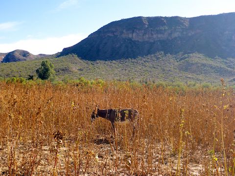
I slipped past the gate, and started hiking down Table Mesa Rd. Wild Burro Mesa to my left, Dutch Butte to my right, with White Bluffs and Indian Mesa visible dead ahead. Between the first and second locked gate is what appears to be a vehicle campground, with the host’s RV still onsite. There’s also a sign indicating trails to the left: Ignore it. Stay on Table Mesa Rd. Like I said, confusing.
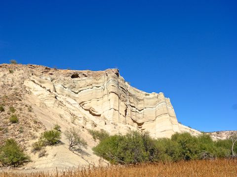
The second gate marks the boundary of Lake Pleasant Regional Park. Just past the gate, is the Agua Fria River. On the left is a California fan palm, but the jeep trail curves right. Unsure which way to go, and with yet more confusing signs, I went left, hiking down the dry river bed. 🤔
As I hiked down the Agua Fria River, I was looking for the road which I knew crossed over the saddle between Indian Mesa and Dutch Butte. I thought I found it on the dry river bank, but no. After a half mile, I exited the river bed to my right, picking up a jeep trail that curled east, ending up back at the California fan palm. Yes, that was the road I should have been on.
Long story short, at the fan palm, follow the road right, then stay between the poles across the Agua Fria River, to pick up the jeep trail on the other side. As long as you are hiking to Indian Mesa Ruins after mid-June and before mid-December, ignore any “area closed” signs: They are meant for vehicles.
The jeep trail is smooth, and still in shade at 9:15 a.m. Here and there, the jeep trail has iron tube fencing with no parking signs. On a road that does not allow vehicles. At 1¼ miles, the jeep trail expands into a large, grassy, lot that was apparently once a boat ramp. There are two picnic tables and a portapotty that did not stink. And, of course, more signs. 🚧
The grassy lot has two locked gates, left and right. Unsure which way to go, I went right. It should come as no surprise, the correct way is left. The jeep trail crosses dusty Boulder Creek. At the large tree on the far side, turn right to stay on the jeep trail for a pain-free path through the cockleburs. I, of course, went left, once again travelling the still dry bed of the Agua Fria River.
In the course of my wandering a group of older folks had passed me, so I followed them down the Agua Fria River, skirting the cockleburs. (Note that the GPS route attached below, shows the correct route to Indian Mesa, without any misdirection.) Eventually, we found our way back to the jeep trail, where it begins its ascent to the saddle between Indian Mesa and Dutch Butte.
What was once smooth, easy, jeep trail becomes extremely rugged Cow Creek Rd. Due to deep erosion — especially on the initial climb — even a heavy duty 4×4 would be unwise. But on foot, Cow Creek Rd. was no problem. What may have seemed a difficult climb from the trailhead, is no problem, only 300 ft. in ¾ of a mile. 👍
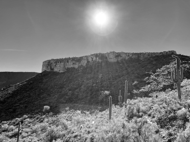
Just before reaching the high point of Cow Creek Rd., on the left is a cairn. Head up that trail, aiming for the saddle between Indian Mesa and the small hill to its right. Despite climbing 200 ft. in 250 yds., the foot trail is also no problem. At the saddle turn left, for a short traverse along the Indian Mesa cliff band. When you see a short wall, with arrow holes, climb 6 ft. up the crack towards the brown sign.
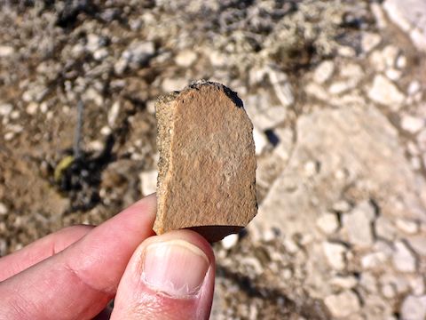
The top of Indian Mesa has fantastic 360° views. I took the older folks’ photo, then started exploring. Most of the ruins are clustered at the west end of Indian Mesa. One of the ruins had an indentation, which may look like a metate but which most folks believe is a post hole for roof support. I saw no evidence of wood on the summit, living or worked.
The Indian Mesa summit is very exposed: the only shade is scrunching into the corner of a ruined wall. The vegetation consists of the usual Sonoran Desert species: ocotillo, several varities of cholla, creosote, prickly pear, small palo verde, a few immature saguaro, strawberry hedgehog, and a noticeably large quantity of Arizona fishhook cactus. 🌵
I tend to regularly wander off trail beause I spend my time looking down, to avoid ankle breakers, but snakes too. Good thing, as I almost stepped on a tiny one, maybe 6″ long. I thought at first he was harmless, but then I realized his pattern matched that of a tiger snake. His rattle was so small — a ¼” at most — that it was almost invisible, and definitely inaudible.
The older folks left awhile before me, but going downhill and not wandering caught me up to them near the grassy lot. So, we spent the last mile back to the trailhead chatting. Nice folks. 🙂
Directions: From Phoenix, head north on I-17 / Black Canyon Freeway. Take Exit 236 west, onto Table Mesa Rd. After passing over I-17, take the first right. Table Mesa Rd. becomes smooth dirt. You will pass a number of firing ranges and OHV trailheads. The Upper Parking Lot is on the right in 4.5 miles. There is a $7 parking fee.
Park Map: Lake_Pleasant_Regional_Park_Map
GPS File: Indian_Mesa_Ruins
Distance: 8.78 mi.
AEG: 847 ft.
Time: 3h 31m
Hiking Video
Indian Mesa Ruins from Preston McMurry on Vimeo.