

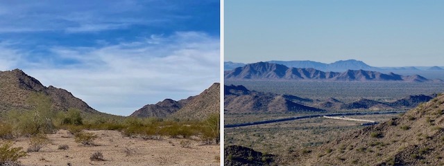
What is now known as the Butterfield Stage Trail was in use at least as early as Juan Bautista de Anza’s expedition from Culiacan to San Francisco in 1775. de Anza was followed by the Mormon Battalion in 1846, and the Overland Mail Company from 1858-1861. They all seem to have followed the route from Maricopa Wells, straight through Butterfield Pass, to what is now Gila Bend.
Why they did not follow the Gila River, I do not know. It’s only 30 miles more, but with water. Perhaps the indians were hostile further north? Though Butterfield Pass is not extreme, its canyons certainly make ambush easier. So, having cut across the waterless curve of the Gila River, why not take the less constricted route through much wider, shallower, Shawmut Pass only four miles south?
0.0 mi.: Estrella Road Trailhead is a gravel lot, large enough for horse trailers. It has a trail registry, info board, maps you can take with you, three concrete picnic tables, two grills, and a fire pit — but no pit toilet. Still, can’t complain, as it is now open. (BLM closed the Sonoran Desert National Monument to vehicles in 2008.) BLM 8002 is wide, smooth, gravel. I followed vehicle tracks to avoid mushiness.
2.2 mi.: Sandy “Arizona crossing” across an anonymous wash. A quarter mile later, the gravel changes to smooth dirt. I rode all the little washes BLM 8002 crossed, but this one I walked. And I knew I would walk many more on the west side of Butterfield Pass. (Which I hiked back in 2014.) Btw, “Arizona crossing” is not a location, but the actual technical term for a concrete slab across low-flow streams.
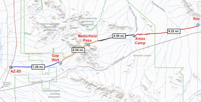
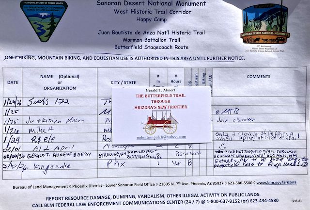
4.3 mi.: There were at least three registries on today’s bike ride: At the Estrella Road Trailhead; the de Anza Registry, here at the east end of Butterfield Pass, at the intersection of BLM 8002 and BLM 8003; and at the west end of the pass at Happy Camp / Fortymile Desert Tank. Probably because they are within, or bordering, the Sonoran Desert National Monument. Nothing near Gap Well though.
5.8 mi.: Butterfield Stage Trail climbs steadily, 150 ft. in 1.5 miles to Butterfield Pass. Right / north of BLM 8003, fiberglass posts, with white stickers, mark the border of the North Maricopa Mountains Wilderness. (A no vehicles — not even mountain bikes! — subsection of the Sonoran Desert National Monument.) There’s some mush, but not bad. It doesn’t get rocky until 200 yds. from the summit.
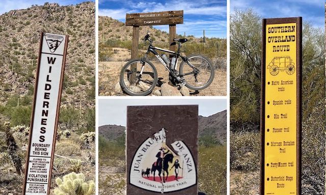
This Butterfield Stage Trail segment is also marked by Juan Bautista de Anza and yellow Overland Route signs. Sometimes on opposite sides of the same fiberglass post. The signs follow the least mushy route west of Butterfield Pass, though that is not, according to the topo, the strictly accurate Butterfield Stage Trail route. (Particularly between Happy Camp / Fortymile Desert Tank and Gap Well.) 🤔
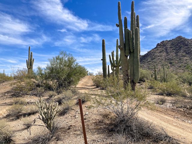
Butterfield Stage Trail steadily descends all the way from Butterfield Pass to Gap Well. But the only noticeable part is the first quarter mile. It’s not extreme by any means, but you could get some zip despite the rocks. Afterwards, the trail alternates between smooth, crossing washes, and following washes. Fat tire recommended. The big mountain on the left is the Estrella 2766 benchmark.
7.4 mi.: I rode when I could, but pushed often to the guzzler. “What is a guzzler?”, you are wondering. Usually, they consist of a concrete apron to collect rain over a couple of thousand square foot area, channel it into a cistern, covered to reduce evaporation, then into a basin which wildlife can drink out of. Guzzlers are all over the Sonoran Desert. If you’ve never seen one, check it out; otherwise, skip it.
8.1 mi.: The Butterfield Stage Trail arrives at Happy Camp / Fortymile Desert Tank. (Forty miles from what?) During Old West days, Happy Camp was the first water available to travellers since Maricopa Wells, 30 miles east. But there is no spring at Fortymile Desert Tank, so water had to be hauled to Happy Camp from the Gila River, still 12 miles west. (Phoenix didn’t yet exist to suck the Gila River dry.)
Butterfield Stage Trail is much less sandy after the guzzler. I zipped along BLM 8003, past much less defined BLM 8004F. (Which only saves a half mile to Gap Well.) This is another section where the trail’s route differs between the topo and the on-the-ground current reality. Like the issues I faced on the General Crook Trail. And, like on Crook, I settled on following the signs.
10.8 mi.: There’s a Juan Bautista de Anza history sign identical to the one at the east end of Butterfield Pass. (But more sunwashed.) I didn’t notice a registry. Turn south (left) on BLM 8004 to Gap Well. Continue west (right) to continue on Butterfield Stage Trail.
11.1 mi.: Gap Well is only a quarter mile after the turn onto BLM 8004. There’s a decent size corral, and a large concrete tank. The tank is dry because there is no spring or well. (See the video thumbnail, below.) The pit toilet is just across the road. I had planned to continue riding another mile to AZ-238, but my ever helpful shuttle-driving wife chose to wait for me by the clean, little-used, facilities.
Estrella Road Directions: From Phoenix, head south on I-10. Take exit 164 onto AZ-347. In 14.7 miles, just after entering Maricopa, turn right on AZ-238. Just east of milepost 21, turn right on BLM 8002 / Estrella Rd. Park in the gravel lot. If you want a shorter ride, a SUV (maybe even a car) could easily continue 4.4 miles north on BLM 8002 to the de Anza Registry.
Gap Well Directions: Continuing on AZ-238, a quarter mile past milepost 15, turn right into the West Butterfield Road Parking Area. Cars should park there. SUVs or better may continue through the wire gate on BLM 8004, for 1.2 mi. to the Gap Well pit toilet.
GPS File: Butterfield_Stage_de_Anza_Registry_to_Gap_Well
Distance: 13.06 mi.
AEG: 295 ft.
Time: 2h 44m
Rumble Video
Vimeo Video
Butterfield Stage Trail: de Anza Registry to Gap Well from Preston McMurry on Vimeo.