

On our last visit to Maryland, I biked the Great Allegheny Passage from Cumberland to Frostburg. Afterwards, I started breaking down the remaining GAP Trail miles to Pittsburgh. Rail trails are not at all difficult, rarely above 2% grade. Unfortunately, it would take us further & further away from family in Hagerstown, and family is why we visit Maryland. The non-bikecamping logistics were too difficult. 😕
Instead, I decided to return to the Appalachian Trail.
The last time I day-hiked the A.T. was my favorite ever hike, Pen Mar to Old Forge, Pennsylvania. Hiking in the snow over Mount Dunlop was so peaceful.
Limiting myself to a 90-minute drive from Hagerstown — remember, family time — today I hiked my first Appalachian Trail segment in Virginia, from Ashby’s Gap to Mount Weather.
We left Hagerstown at 7:00 a.m., cruising down I-81 to US-50 in Winchester, no problem. The turn off US-50 onto VA-601 / Blue Ridge Mountain Rd. was obvious. The Ashby’s Gap Trailhead was not. Drove right past it. Had to be careful turning around on twisty VA-601, which had quite a bit of traffic for a small road. (Probably due to the FEMA facility on Mount Weather.) Just 0.3 miles after turning onto VA-601, there is a yellow “twisty road, 25 mph” sign: Turn left there. (The trailhead sign blends in with the trees.) It’s looks like you’re driving off the bluff, but you’re not.
0.0 mi.: From the Ashby’s Gap Trailhead an access spur drops 100 yds. to an “Appalacian Trail” [sic] sign. Surprised no one carved in the missing “H”. I turned right, to go north. The Appalachian Trail climbs 190 ft. in the next half mile, then rolls along for two miles after that.
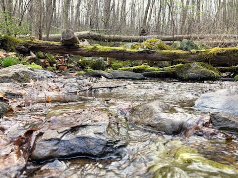
1.3 mi.: The first branch of Hidden Hollow that the Appalachian Trail crosses. It had good flow.
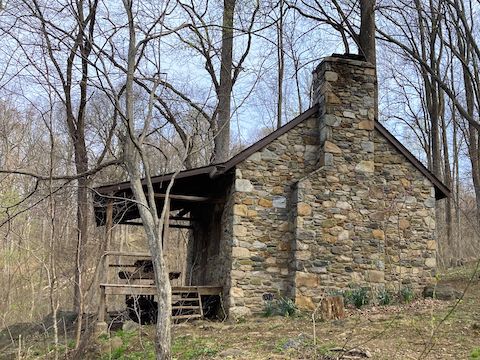
1.7 mi.: I diverted left, towards Myron Glaser Cabin. The Appalachian Trail proper continues straight. Either choice is basically the same distance and minimal elevation gain. Just below the cabin, the second branch of Hidden Hollow was also flowing. Myron Glaser Cabin sleeps 12, but is only available to members of the Potomac Appalachian Trail Club. No rule (?) against camping on the porch, which has a swing and picnic table, but everything else is locked up, including the outhouse.
2.6 mi.: By the time the Appalachian Trail crossed Duke Hollow, the fog had cleared. Duke Hollow had decent flow. I checked out the old stone wall on the north bank of the creek.
3.0 mi.: Fisher Hill Loop Trail splits left. I did not hike it to confirm where it ends, but supposedly it reconnects to the Appalachian Trail near the bottom of The Rollercoaster. From the Fisher Hill saddle, the A.T. passed through a nice patch of Virginia bluebell on the descent to Rod Hollow — which had boardwalks either side of Rod Hollow Shelter.
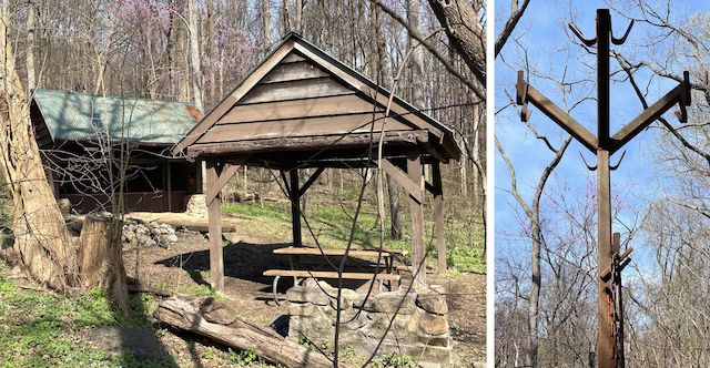
3.4 mi.: Rod Hollow Shelter is 200 yds. west of the Appalachian Trail, at the base of Fisher Hill. The 3-sided shelter has two decks (upper accessible by ladder), two fire pits, a picnic cabana, at least three gravel tent pads, and an unlocked outhouse. The creek had okay flow. The logbook warned about rabid raccoons and falling walnuts. I guess they hurt? I only saw them on the ground.
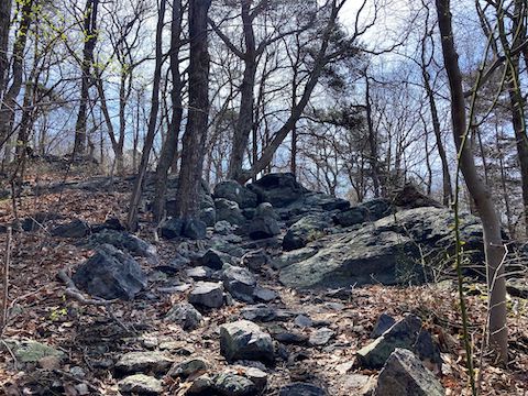
3.8 mi.: Back on the Appalachian Trail, The Rollercoaster starts on the north side of Rod Hollow. The Rollercoaster is a series of roughly half mile 400 ft. climbs (~15% slope), followed by matching descents. Mostly switchbacked. Sometimes rather rocky. The Rollercoaster ends at Bears Den Lookout, above VA-7 at Snicker’s Gap. (The end of my intended hike on Monday.)
5.0 mi.: Morgan Mill Stream had no flow. It was just wet. The Rollercoaster’s 480 ft. second climb is to the top of Piney Ridge, which had a bit of a view to the east, towards the summit of Mount Weather. With the climbs, and mid-day warmth, I sweating under my hoodie. (No place to store it, as I was only carrying a Camelbak.)
6.5 mi.: Ashby Hollow had decent flow. There’s a small wooden bridge over the creek, which is paralleled by a decent gravel road. I didn’t explore it, but the gravel road looks like it connects downhill to Cliff Lane, and uphill to … who knows. Maybe the FEMA facility on Mount Weather?

Top Row: rue anemone, common blue violet, downy yellow violet.
Middle Row: eastern redbud, wild daffodil, eastern spring beauty.
Bottom Row: star chickweed, Virginia bluebell, dandelion.
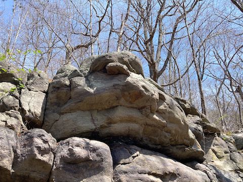
7.1 mi.: The trailhead on Morgan’s Mill Rd. is 150 yds. west of the Appalachian Trail. I lost the trail for a few minutes in some boulders above Ashby’s Hollow. It would have been shorter to cut uphill to the trailhead, but I wanted to lay down an accurate and complete track, so I dur-hur’d for a bit.
Leaving Mount Weather, we continued north on VA-601 / Blue Ridge Mountain Rd. to VA-7, taking that back into Winchester. The transition from VA-7 onto I-81 was backed up a mile, which seems common in towns along I-81. The interstate, itself, was busy, but moving. Until we got into West Virginia. Then I-81 was gridlocked. We’d move a car length. Standstill for a minute. Repeat. Finally got off I-81 in Inwood, and took US-11 back to Hagerstown. (2½ hours into a 75-minute drive.)
I was so disgusted I decided to skip my Monday Appalachian Trail hike from Mount Weather to Snicker’s Gap. I don’t need that kind of stress. 😫
Ashby’s Gap Directions: From I-81 in Winchester, Virginia, take exit 313A east onto US-50. In 15.3 miles, turn left onto VA-601 / Blue Ridge Mountain Rd. In 0.3 miles, Ashby’s Gap Trailhead is on the left.
Mount Weather Directions: Continue north on VA-601 / Blue Ridge Mountain Rd. for another 6.0 miles. You will pass by lots of fences, and cameras, and other secret stuff. If you stay on the road, you are okay. Just after passing under a bridge, turn left onto VA-605 / Morgan’s Mill Rd. In 1.3 miles, park at the Pua Falls Trailhead.
GPS File: AT_Ashbys_Gap_to_Morgans_Mill_Road
Distance: 8.28 mi.
AEG: 1,839 ft.
Time: 3h 38m
Rumble Video
Vimeo Video
Appalachian Trail: Ashby’s Gap to Mount Weather from Preston McMurry on Vimeo.